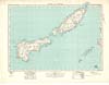
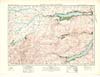
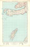
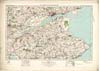
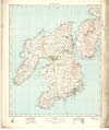
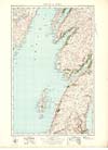
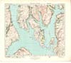
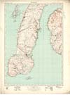
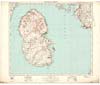
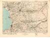
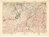
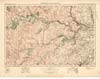
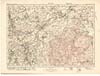
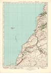
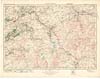
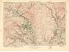
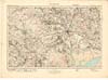
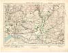
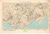
| Description | Sheet 1 of the Ordnance Survey One-inch Popular Edition of Scotland. It was issued in 1931 at a scale of 1 inch to 1 mile (1: 63,360) from a survey done in 1928. The first Ordnance Survey of this area was done between 1877 and 1878. This sheet shows the northernmost of the Shetland Isles, the island of Yell on the lower left (south west) part of the sheet, with the island of Fetlar on the right side, east of Yell, and the island of Unst at the top (north). The north east tip of Mainland can be seen in the bottom left (south west) corner. When this map was printed, and indeed until the March 1995, the islet of Muckle Flugga off the northern tip of Unst, was the most northerly inhabited part of Britain, having permanent staff on the lighthouse. However, once the lighthouse was automated and the staff withdrawn, the honour of being the most northerly inhabited part of Britain fell to Unst itself. On the right, the sheet stretches, in the north, from a point in the North Atlantic approximately 60 degrees 51 minutes north, and 41 minutes west, north and east of Unst, to, in the south, a point in the North Atlantic approximately 60 degrees and 28 minutes north, and 41 minutes west. On the left, the sheet stretches, in the north, from a point in the North Atlantic approximately 60 degrees 51 minutes north, and 1 degree 14 minutes west to, in the south, a point on Mainland just south of Mio Ness and just west of Fugla Ness. There are two sets of References, the scale statement ‘One Inch to One Statute Mile - 1/63360’, with accompanying scale bar, and two further scale bars of 1 centimetre to 1000 yards and 1 centimetre to 1 kilometre. Contours and fathoms are shown, with accompanying information about measurement |