Saddell and Skipness -- Skene
(566) Page 32
Download files
Complete book:
Individual page:
Thumbnail gallery: Grid view | List view
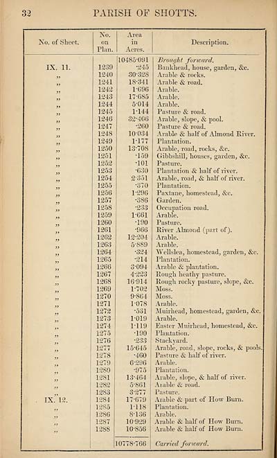
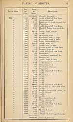
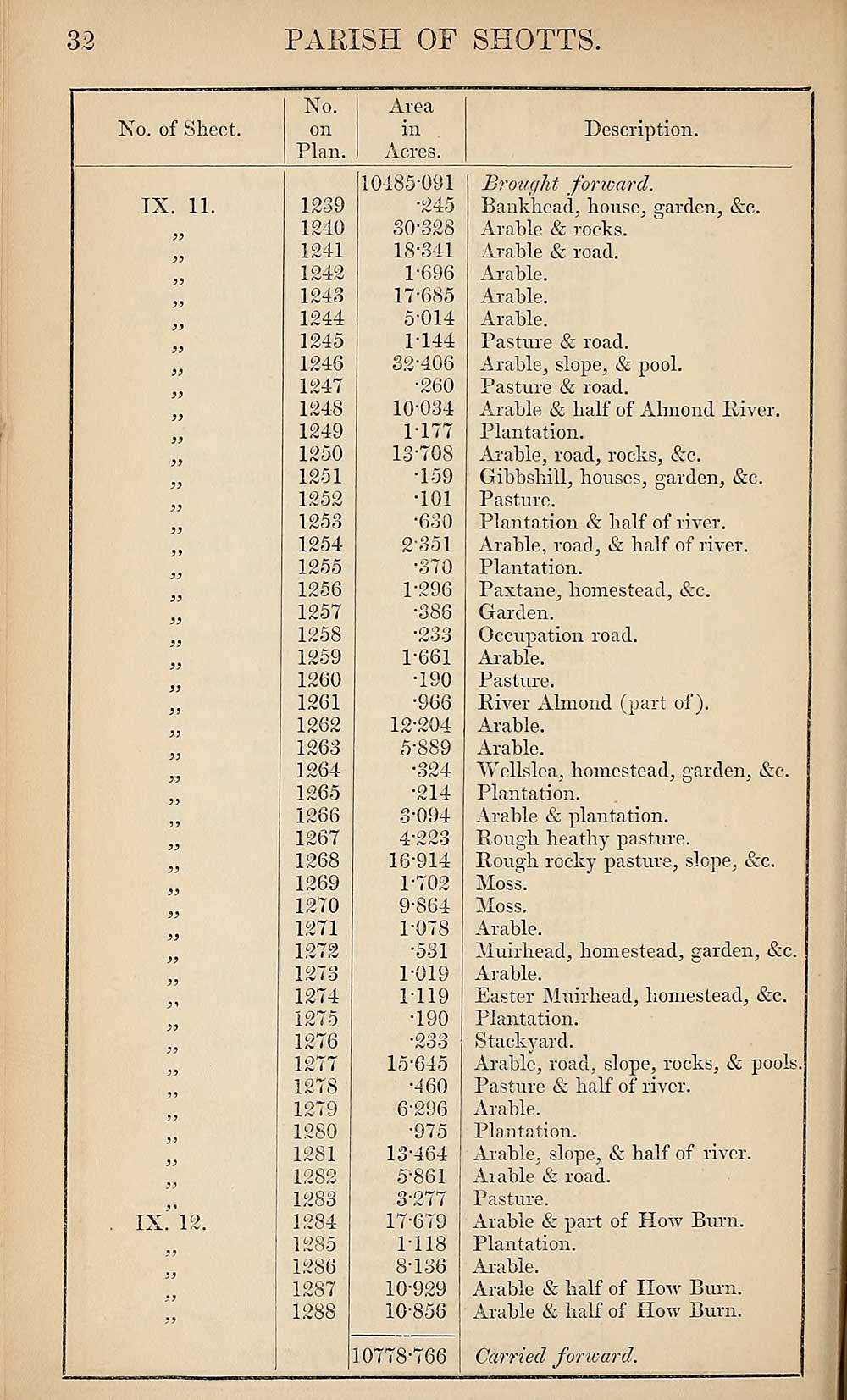
32
PARISH OF SHOTTS.
No. of Sheet.
No.
on
Plan.
Area
in
Acres.
Description.
IX. 11.
IX. 12.
1239
1240
1241
1242
1243
1244
1245
1246
1247
1248
1249
1250
1251
1252
1253
1254
1255
1256
1257
1258
1259
1260
1261
1262
1263
1264
1265
1266
1267
1268
1269
1270
1271
1272
1273
1274
1275
1276
1277
1278
1279
1280
1281
1282
1283
1284
1285
1286
1287
1288
10485-091
•245
30-328
18-341
1-696
17-685
5-014
1-144
32-406
■260
10034
1- 177
13-708
•159
•101
•630
2- 351
•370
1-296
•386
•233
1-661
•190
•966
12- 204
5- 889
•324
•214
3- 094
4- 223
16- 914
1-702
9-864
1-078
•531
1-019
1-119
•190
•233
15-645
•460
6- 296
*975
13- 464
5- 861
3*277
17- 679
1-118
8-136
10-929
10-858
0778"766
Brought forward.
Bankhead, house, garden, &c.
Arable & rocks.
Arable & road.
Arable.
Arable.
Arable.
Pasture & road.
Arable, slope, & pool.
Pasture & road.
Arable & half of Almond River.
Plantation.
Arable, road, rocks, &c.
Gibbshill, houses, garden, &c.
Pasture.
Plantation & half of river.
Arable, road, & half of river.
Plantation.
Paxtane, homestead, &c.
Garden.
Occupation road.
Arable.
Pasture.
River Almond (part of).
Arable.
Arable.
Wellslea, homestead, garden, &c.
Plantation.
Arable & plantation.
Rough heathy pasture.
Rough rocky pasture, slope, tkc.
Moss.
Moss.
Arable.
Muirhead, homestead, garden, &c.
Arable.
Easter Muirhead, homestead, &e.
Plantation.
Stackyard.
Arable, road, slope, rocks, & pools.
Pasture & half of river.
Arable.
Plantation.
Arable, slope, & half of river.
Arable & road.
Pasture.
Arable & part of How Burn.
Plantation.
Arable.
Arable & half of How Burn.
Arable & half of How Burn.
Carried forward.
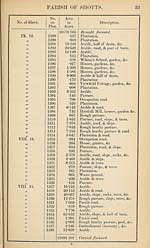
Set display mode to:
![]() Universal Viewer |
Universal Viewer | ![]() Mirador |
Large image | Transcription
Mirador |
Large image | Transcription
Images and transcriptions on this page, including medium image downloads, may be used under the Creative Commons Attribution 4.0 International Licence unless otherwise stated. ![]()
| Ordnance Survey Books of Reference 1855-1882 > Saddell and Skipness -- Skene > (566) Page 32 |
|---|
| Permanent URL | https://digital.nls.uk/99357387 |
|---|
| Attribution and copyright: |
|
|---|---|
| Description | These volumes record acreages of fields and land-use information for each parish in Scotland from 1855-1882. They were compiled with the Ordnance Survey 25 inch to the mile maps for that period, which cover all the inhabited parts of Scotland. Numbered land parcels on these maps, listed consecutively within each parish, are included in the relevant parish Book of Reference. |
|---|---|
| Shelfmark | Map.Ref.C18 |
| Additional NLS resources: | |