Saddell and Skipness -- Skene
(565) Page 31
Download files
Complete book:
Individual page:
Thumbnail gallery: Grid view | List view
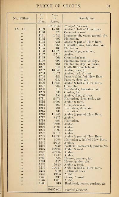
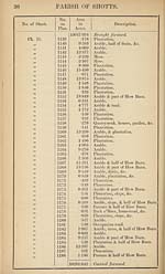
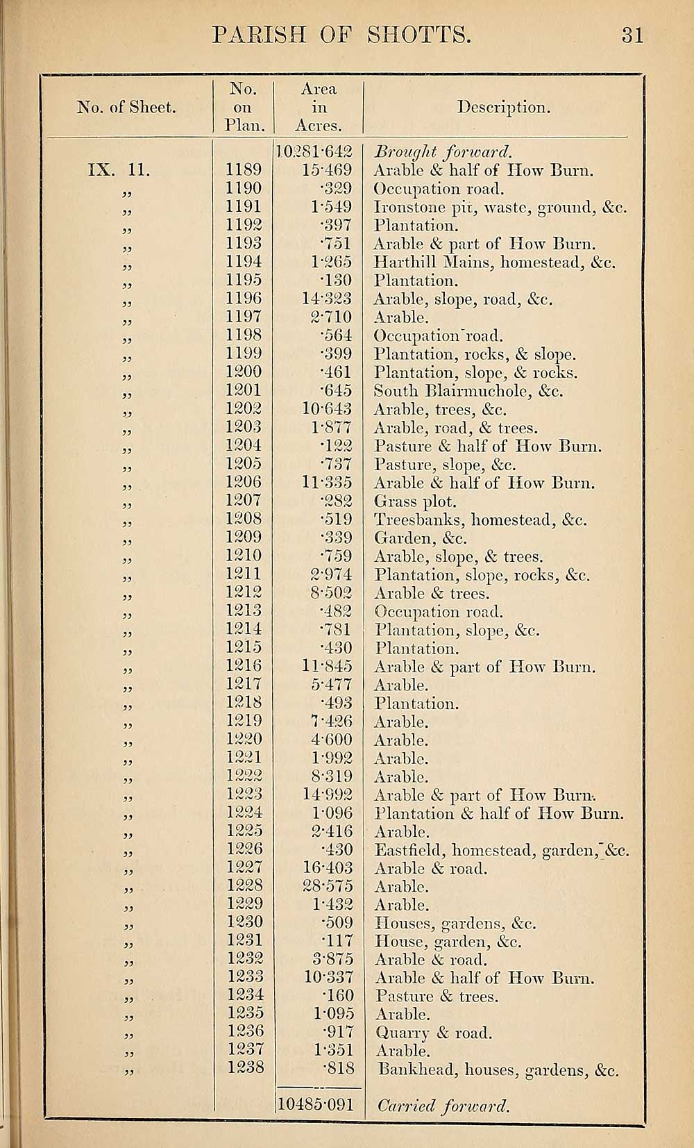
PARISH OF SHOTTS
31
No. of Sheet.
No.
on
Plan.
Area
in
Acres.
Description.
IX. 11.
1189
1190
1191
1192
1193
1194
1195
1196
1197
1198
1199
1200
1201
1202
1203
1204
1205
1206
1207
1208
1209
1210
1211
1212
1213
1214
1215
1216
1217
1218
1219
1220
1221
I OQO
JL rf'v'rv /V
1223
1224
1225
1226
1227
1228
1229
1230
1231
1232
1233
1234
1235
1236
1237
1238
1028P642
15- 469
•329
1-549
•397
•751
1- 265
-130
14-323
2- 710
■564
•399
•461
•645
10- 643
1- 877
• 1 oo
-L rV.'v'
•737
11- 335
•282
•519
•339
•759
2- 974
8-502
•482
•781
•430
11-845
5-477
•493
1-426
4-600
1- 992
8-319
14-992
1096
2- 416
•430
16- 403
28-575
1-432
•509
•117
3- 875
10-337
•160
1-095
•917
1-351
•818
10485-091
Brough t forward.
Arable & half of How Burn.
Occupation road.
Ironstone pit, waste, ground, &c.
Plantation.
Arable & part of How Burn,
liar thill Mains, homestead, &c.
Plantation.
Arable, slope, road, &c.
Arable.
Occupation'road.
Plantation, rocks, & slope.
Plantation, slope, & rocks.
South Blairmuchole, &c.
Arable, trees, &c.
Arable, road, & trees.
Pasture & half of How Burn.
Pasture, slope, &c.
Arable & half of How Burn.
Grass plot.
Treesbanks, homestead, &c.
Garden, &c.
Arable, slope, & trees.
Plantation, slope, rocks, &c.
Arable & trees.
Occupation road.
Plantation, slope, &c.
Plantation.
Arable & part of How Burn.
Arable.
Plantation.
Arable.
Arable.
Arable.
Arable.
Arable & part of How Burn-.
Plantation & half of How Burn.
Arable.
Eastfield, homestead, garden,’&c.
Arable & road.
Arable.
Arable.
Houses, gardens, &c.
House, garden, &c.
Arable & road.
Arable & half of How Burn.
Pasture & trees.
Arable.
Quarry & road.
Arable.
Bankhead, houses, gardens, &c.
Carried for iv a fid.
31
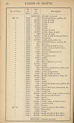
No. of Sheet.
No.
on
Plan.
Area
in
Acres.
Description.
IX. 11.
1189
1190
1191
1192
1193
1194
1195
1196
1197
1198
1199
1200
1201
1202
1203
1204
1205
1206
1207
1208
1209
1210
1211
1212
1213
1214
1215
1216
1217
1218
1219
1220
1221
I OQO
JL rf'v'rv /V
1223
1224
1225
1226
1227
1228
1229
1230
1231
1232
1233
1234
1235
1236
1237
1238
1028P642
15- 469
•329
1-549
•397
•751
1- 265
-130
14-323
2- 710
■564
•399
•461
•645
10- 643
1- 877
• 1 oo
-L rV.'v'
•737
11- 335
•282
•519
•339
•759
2- 974
8-502
•482
•781
•430
11-845
5-477
•493
1-426
4-600
1- 992
8-319
14-992
1096
2- 416
•430
16- 403
28-575
1-432
•509
•117
3- 875
10-337
•160
1-095
•917
1-351
•818
10485-091
Brough t forward.
Arable & half of How Burn.
Occupation road.
Ironstone pit, waste, ground, &c.
Plantation.
Arable & part of How Burn,
liar thill Mains, homestead, &c.
Plantation.
Arable, slope, road, &c.
Arable.
Occupation'road.
Plantation, rocks, & slope.
Plantation, slope, & rocks.
South Blairmuchole, &c.
Arable, trees, &c.
Arable, road, & trees.
Pasture & half of How Burn.
Pasture, slope, &c.
Arable & half of How Burn.
Grass plot.
Treesbanks, homestead, &c.
Garden, &c.
Arable, slope, & trees.
Plantation, slope, rocks, &c.
Arable & trees.
Occupation road.
Plantation, slope, &c.
Plantation.
Arable & part of How Burn.
Arable.
Plantation.
Arable.
Arable.
Arable.
Arable.
Arable & part of How Burn-.
Plantation & half of How Burn.
Arable.
Eastfield, homestead, garden,’&c.
Arable & road.
Arable.
Arable.
Houses, gardens, &c.
House, garden, &c.
Arable & road.
Arable & half of How Burn.
Pasture & trees.
Arable.
Quarry & road.
Arable.
Bankhead, houses, gardens, &c.
Carried for iv a fid.
Set display mode to:
![]() Universal Viewer |
Universal Viewer | ![]() Mirador |
Large image | Transcription
Mirador |
Large image | Transcription
Images and transcriptions on this page, including medium image downloads, may be used under the Creative Commons Attribution 4.0 International Licence unless otherwise stated. ![]()
| Ordnance Survey Books of Reference 1855-1882 > Saddell and Skipness -- Skene > (565) Page 31 |
|---|
| Permanent URL | https://digital.nls.uk/99357375 |
|---|
| Attribution and copyright: |
|
|---|---|
| Description | These volumes record acreages of fields and land-use information for each parish in Scotland from 1855-1882. They were compiled with the Ordnance Survey 25 inch to the mile maps for that period, which cover all the inhabited parts of Scotland. Numbered land parcels on these maps, listed consecutively within each parish, are included in the relevant parish Book of Reference. |
|---|---|
| Shelfmark | Map.Ref.C18 |
| Additional NLS resources: | |