Keig -- Kilmaronock
(190) Page 10

Thumbnail gallery: Grid view | List view

10
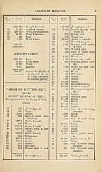
PARISH OF KETTINS (DETACHED).
No. on
Plan.
Area in
Acres.
Description.
No. on
Plan.
Area in
Acres.
Description.
55
335-337
•057
335-394
Brought forward.
Strip of arable along
boundary.
Carried forward.
56
335-394
•101
335-495
Brought forward.
Strip of arable along
boundary.
RECAPITULATION.
330-314
4-688
•493
335-495
Land.
Public road.
Water.
Area of tbe Parish of Kettins (Detached), in the
County of Forfar (Detached).
RECAPITULATION FOR THE PARISH.
7682-871
103-953
20-131
8-917
7815-872
Land.
Public roads.
Water.
Railway.
Total Area of the Parish of Kettins, in the County of Forfar.
Set display mode to:
![]() Universal Viewer |
Universal Viewer | ![]() Mirador |
Large image | Transcription
Mirador |
Large image | Transcription
Images and transcriptions on this page, including medium image downloads, may be used under the Creative Commons Attribution 4.0 International Licence unless otherwise stated. ![]()
| Ordnance Survey Books of Reference 1855-1882 > Keig -- Kilmaronock > (190) Page 10 |
|---|
| Permanent URL | https://digital.nls.uk/99290467 |
|---|
| Attribution and copyright: |
|
|---|---|
| Description | These volumes record acreages of fields and land-use information for each parish in Scotland from 1855-1882. They were compiled with the Ordnance Survey 25 inch to the mile maps for that period, which cover all the inhabited parts of Scotland. Numbered land parcels on these maps, listed consecutively within each parish, are included in the relevant parish Book of Reference. |
|---|---|
| Shelfmark | Map.Ref.C18 |
| Additional NLS resources: | |