Keig -- Kilmaronock
(189) Page 9
Download files
Complete book:
Individual page:
Thumbnail gallery: Grid view | List view
PARISH OF KETTINS.
9
No. on
Plan.
Area in
Acres.
Description.
No. on
Plan.
Area in
Acres.
Description.
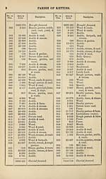
669
670
671
672
673
7153-719
31-652
208-770
34-921
•187
1-128
7480-377
Brought forward.
Arable & stream.
Wood, streams, &roads.
Wood & streams.
Pond.
Wood & road.
RECAPITULATION.
7352-557
99-265
19-638
8-917
7480-377
Land.
Public roads.
Water.
Railway.
Area of the Parish of
Kettins, in the Co
of Forfar (exclusive
of detached portion)
PARISH OF KETTINS (DET),
IN THE
COUNTY OF FORFAR (DET),
Locally situated in the County of Perth.
1
2
3
4
5
6
7
8
9
10
11
12
13
14
15
•057
•825
13-382
•247
12-678
•237
20-162
15-754
12-552
•470
9-875
8-469
•273
•247
•679
95-907
along
Arable & pond.
Wood.
Arable.
Strip of arable
boundary.
Arable & wood.
Wood.
Arable & wood.
Arable, wood, & foot-
path.
Arable~&fwood.
Private road.
Arable.
Arable.
Arable.
Mill dam.
Houses, yard, & road.
Carried forward.
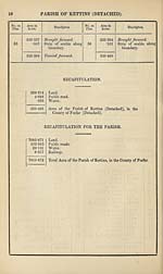
16
17
18
19
20
21
22
23
24
25
26
27
28
29
30
31
32
33
34
35
36
37
38
39
40
41
42
43
44
45
46
47
48
49
50
51
52
53
54
95-907
1-501
•497
•739
23-485
•582
1- 831
•997
T42
2- 321
4-688
•898
1-042
•654
•246
7-993
7-561
12-228
51-242
10- 003
1- 448
1-118
12-056
11- 324
*605
10-164
19-351
•106
3- 064
•361
•199
10-381
2- 874
1- 304
14-413
2- 391
16-993
2-049
•360
•219
335-337
Brought forward.
House, garden, yard,
wood, &c.
Private road.
Wood, &c.
Arable & footpaths.
Wood & footpaths.
Houses, yard, arable,
& road.
Wood & pond.
Strip of arable along
boundary.
Wood, &c.
Statute labor road.
Houses, garden, yard,
&c.
Wood, mill dam (part
of), &c.
Wood.
Mill dam.
Arable.
Arable.
Arable.
Wood & footpaths.
Arable & footpath.
Houses, gardens, yards,
&c.
Arable.
Arable & furze.
Arable.
Wood.
Arable.
Arable.
Strip of arable along
boundary.
Wood.
Wood.
Strip of arable along
boundary.
Arable.
Arable.
Wood.
Arable.
House, garden, wood,
&c.
Arable, dovecot, &c.
Wood.
Strip of arable along
boundary.
Strip of arable along
boundary.
Carried forward.
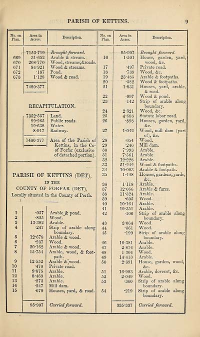
9
No. on
Plan.
Area in
Acres.
Description.
No. on
Plan.
Area in
Acres.
Description.
669
670
671
672
673
7153-719
31-652
208-770
34-921
•187
1-128
7480-377
Brought forward.
Arable & stream.
Wood, streams, &roads.
Wood & streams.
Pond.
Wood & road.
RECAPITULATION.
7352-557
99-265
19-638
8-917
7480-377
Land.
Public roads.
Water.
Railway.
Area of the Parish of
Kettins, in the Co
of Forfar (exclusive
of detached portion)
PARISH OF KETTINS (DET),
IN THE
COUNTY OF FORFAR (DET),
Locally situated in the County of Perth.
1
2
3
4
5
6
7
8
9
10
11
12
13
14
15
•057
•825
13-382
•247
12-678
•237
20-162
15-754
12-552
•470
9-875
8-469
•273
•247
•679
95-907
along
Arable & pond.
Wood.
Arable.
Strip of arable
boundary.
Arable & wood.
Wood.
Arable & wood.
Arable, wood, & foot-
path.
Arable~&fwood.
Private road.
Arable.
Arable.
Arable.
Mill dam.
Houses, yard, & road.
Carried forward.
16
17
18
19
20
21
22
23
24
25
26
27
28
29
30
31
32
33
34
35
36
37
38
39
40
41
42
43
44
45
46
47
48
49
50
51
52
53
54
95-907
1-501
•497
•739
23-485
•582
1- 831
•997
T42
2- 321
4-688
•898
1-042
•654
•246
7-993
7-561
12-228
51-242
10- 003
1- 448
1-118
12-056
11- 324
*605
10-164
19-351
•106
3- 064
•361
•199
10-381
2- 874
1- 304
14-413
2- 391
16-993
2-049
•360
•219
335-337
Brought forward.
House, garden, yard,
wood, &c.
Private road.
Wood, &c.
Arable & footpaths.
Wood & footpaths.
Houses, yard, arable,
& road.
Wood & pond.
Strip of arable along
boundary.
Wood, &c.
Statute labor road.
Houses, garden, yard,
&c.
Wood, mill dam (part
of), &c.
Wood.
Mill dam.
Arable.
Arable.
Arable.
Wood & footpaths.
Arable & footpath.
Houses, gardens, yards,
&c.
Arable.
Arable & furze.
Arable.
Wood.
Arable.
Arable.
Strip of arable along
boundary.
Wood.
Wood.
Strip of arable along
boundary.
Arable.
Arable.
Wood.
Arable.
House, garden, wood,
&c.
Arable, dovecot, &c.
Wood.
Strip of arable along
boundary.
Strip of arable along
boundary.
Carried forward.
Set display mode to:
![]() Universal Viewer |
Universal Viewer | ![]() Mirador |
Large image | Transcription
Mirador |
Large image | Transcription
Images and transcriptions on this page, including medium image downloads, may be used under the Creative Commons Attribution 4.0 International Licence unless otherwise stated. ![]()
| Ordnance Survey Books of Reference 1855-1882 > Keig -- Kilmaronock > (189) Page 9 |
|---|
| Permanent URL | https://digital.nls.uk/99290455 |
|---|
| Attribution and copyright: |
|
|---|---|
| Description | These volumes record acreages of fields and land-use information for each parish in Scotland from 1855-1882. They were compiled with the Ordnance Survey 25 inch to the mile maps for that period, which cover all the inhabited parts of Scotland. Numbered land parcels on these maps, listed consecutively within each parish, are included in the relevant parish Book of Reference. |
|---|---|
| Shelfmark | Map.Ref.C18 |
| Additional NLS resources: | |