Eday -- Forfar
(696) Page 36
Download files
Complete book:
Individual page:
Thumbnail gallery: Grid view | List view

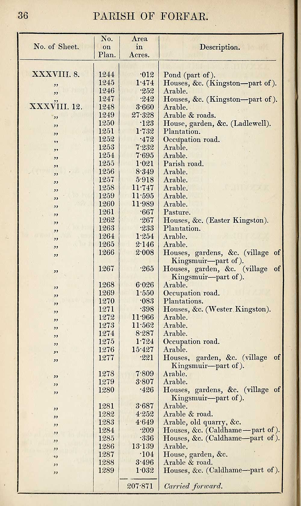
36
PARISH OF FORFAR
No. of Sheet.
No.
on
Plan.
Area
in
Acres.
Description.
XXXVIII. 8.
XXXVIII. 12.
3)
33
33
1244
1245
1246
1247
1248
1249
1250
1251
1252
1253
1254
1255
1256
1257
1258
1259
1260
1261
1262
1263
1264
1265
1266
1267
1268
1269
1270
1271
1272
1273
1274
1275
1276
1277
1278
1279
1280
1281
1282
1283
1284
1285
1286
1287
1288
1289
•012
1-474
•252
•242
3*660
27-328
•123
1-732
•472
7-232
7- 695
1-021
8- 349
5-918
11-747
11-595
11-989
•667
•267
•233
1- 254
2- 146
2-008
•265
6026
1-550
•083
•398
11-966
11-562
8-287
1-724
15-427
•221
7-809
3- 807
•426
3- 687
4- 252
4-649
•209
•336
13139
•104
3-496
1032
207-871
Pond (part of).
Houses, &c. (Kingston—part of).
Arable.
Houses, &c. (Kingston—part of).
Arable.
Arable & roads.
House, garden, &c. (Ladlewell).
Plantation.
Occupation road.
Arable.
Arable.
Parish road.
Arable.
Arable.
Arable.
Arable.
Arable.
Pasture.
Houses, &c. (Easter Kingston).
Plantation.
Arable.
Arable.
Houses, gardens, &c. (village of
Kingsmuir—part of).
Houses, garden, &c. (village of
Kingsmuir—part of).
Arable.
Occupation road.
Plantations.
Houses, &c. (Wester Kingston).
Arable.
Arable.
Arable.
Occupation road.
Arable.
Houses, garden, &c. (village of
Kingsmuir—part of).
Arable.
Arable.
Houses, gardens, &c. (village of
Kingsmuir—part of).
Arable.
Arable & road.
Arable, old quarry, &c.
Houses, &c. (Caldhame—part of).
Houses, &c. (Caldhame—part of ).
Arable.
House, garden, &c.
Arable & road.
Houses, &c. (Caldhame—part of).
Carried forward.
Set display mode to:
![]() Universal Viewer |
Universal Viewer | ![]() Mirador |
Large image | Transcription
Mirador |
Large image | Transcription
Images and transcriptions on this page, including medium image downloads, may be used under the Creative Commons Attribution 4.0 International Licence unless otherwise stated. ![]()
| Ordnance Survey Books of Reference 1855-1882 > Eday -- Forfar > (696) Page 36 |
|---|
| Permanent URL | https://digital.nls.uk/99272551 |
|---|
| Attribution and copyright: |
|
|---|---|
| Description | These volumes record acreages of fields and land-use information for each parish in Scotland from 1855-1882. They were compiled with the Ordnance Survey 25 inch to the mile maps for that period, which cover all the inhabited parts of Scotland. Numbered land parcels on these maps, listed consecutively within each parish, are included in the relevant parish Book of Reference. |
|---|---|
| Shelfmark | Map.Ref.C18 |
| Additional NLS resources: | |