Eday -- Forfar
(697) Page 37
Download files
Complete book:
Individual page:
Thumbnail gallery: Grid view | List view

PARISH OF FORFAR.
37
No. of Sheet.
No.
on
Plan.
Area
in
Acres.
Description.
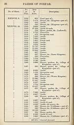
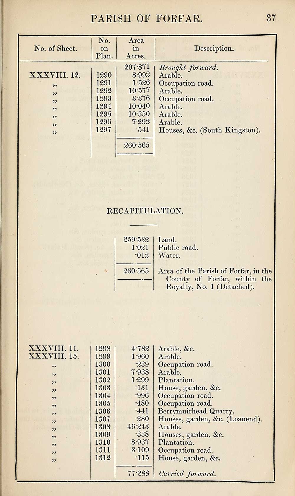
XXXVIII. 12.
5*
3)
33
33
33
33
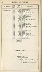
XXXVIII. 11.
XXXVIII. 15.
1290
1291
1292
1293
1294
1295
1296
1297
207*871
8-992
1-526
10-577
3-376
10-040
10-350
7-292
•541
260-565
Brought forward.
Arable.
Occupation road.
Arable.
Occupation road.
Arable.
Arable.
Arable.
Houses, &c. (South Kingston).
RECAPITULATION.
259-532
1-021
•012
260-565
Land.
Public road.
Water.
Area of the Parish of Forfar, in the
County of Forfar, within the
Royalty, No. 1 (Detached).
1298
1299
1300
1301
1302
1303
1304
1305
1306
1307
1308
1309
1310
1311
1312
4-782
1-960
•239
7- 938
1-299
•131
•996
•480
•441
•280
46-243
•338
8- 937
3-109
•115
77-288
Arable, &c.
Arable.
Occupation road.
Arable.
Plantation.
House, garden, &c.
Occupation road.
Occupation road.
Berrymuirhead Quarry.
Houses, garden, &c. (Loanend).
Arable.
Houses, garden, &c.
Plantation.
Occupation road.
House, garden, &c.
Carried forward.
37
No. of Sheet.
No.
on
Plan.
Area
in
Acres.
Description.
XXXVIII. 12.
5*
3)
33
33
33
33
XXXVIII. 11.
XXXVIII. 15.
1290
1291
1292
1293
1294
1295
1296
1297
207*871
8-992
1-526
10-577
3-376
10-040
10-350
7-292
•541
260-565
Brought forward.
Arable.
Occupation road.
Arable.
Occupation road.
Arable.
Arable.
Arable.
Houses, &c. (South Kingston).
RECAPITULATION.
259-532
1-021
•012
260-565
Land.
Public road.
Water.
Area of the Parish of Forfar, in the
County of Forfar, within the
Royalty, No. 1 (Detached).
1298
1299
1300
1301
1302
1303
1304
1305
1306
1307
1308
1309
1310
1311
1312
4-782
1-960
•239
7- 938
1-299
•131
•996
•480
•441
•280
46-243
•338
8- 937
3-109
•115
77-288
Arable, &c.
Arable.
Occupation road.
Arable.
Plantation.
House, garden, &c.
Occupation road.
Occupation road.
Berrymuirhead Quarry.
Houses, garden, &c. (Loanend).
Arable.
Houses, garden, &c.
Plantation.
Occupation road.
House, garden, &c.
Carried forward.
Set display mode to:
![]() Universal Viewer |
Universal Viewer | ![]() Mirador |
Large image | Transcription
Mirador |
Large image | Transcription
Images and transcriptions on this page, including medium image downloads, may be used under the Creative Commons Attribution 4.0 International Licence unless otherwise stated. ![]()
| Ordnance Survey Books of Reference 1855-1882 > Eday -- Forfar > (697) Page 37 |
|---|
| Permanent URL | https://digital.nls.uk/99272563 |
|---|
| Attribution and copyright: |
|
|---|---|
| Description | These volumes record acreages of fields and land-use information for each parish in Scotland from 1855-1882. They were compiled with the Ordnance Survey 25 inch to the mile maps for that period, which cover all the inhabited parts of Scotland. Numbered land parcels on these maps, listed consecutively within each parish, are included in the relevant parish Book of Reference. |
|---|---|
| Shelfmark | Map.Ref.C18 |
| Additional NLS resources: | |