Eday -- Forfar
(354) Index to places
Download files
Complete book:
Individual page:
Thumbnail gallery: Grid view | List view
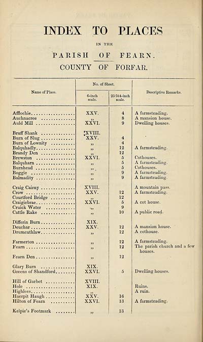
INDEX TO PLACES
IN THE
PARISH OF FEARN
COUNTY OF FORFAR.
Name of Place.
No. of Sheet.
6-inch
scale.
25,344-inch
scale.
Descriptive Remarks.
Afflochie. ..
Auchnacree
Auld Mill .
Bruff Shank . . .
Burn of Slug .. .
Burn of Lownity
Balquhadly
Brandy Den . ..
Brewston
Balquharn
Burnhead
Boggle
Balmadity
Craig Cairny . ..
Crow
Courtford Bridge
Craigiebrae
Cruick Water
Cattle Rake ...
Differin Burn,
Deuchar ....,
Drumcuthlaw.
Farmerton
Fearn . . ..
Fearn Den
Glary Burn
Greens of Shandford.
Hill of Garbet
Hole
Highlees
Haerpit Haugh
Hilton of Fearn
Kelpie’s Footmark
XXV.
XXVI.
'XVIII.
XXV.
XXVI.
>>
>> .
n
XVIII.
XXV.
XXVI.
})
XIX.
XXV.
XIX.
XXVI.
XVIII.
XIX.
XXV.
XXVI.
4
4
12
12
5
5
5
9
9
12
12
5
9
10
12
12
12
12
12
16
13
13
A farmsteading.
A mansion house.
Dwelling houses.
A farmsteading,
Cothouses.
A farmsteading.
Cothouses.
A farmsteading.
A farmsteading.
A mountain pass.
A farm steading.
A cot house.
A public road.
A mansion house.
A cothouse.
A farmsteading.
The parish church and a few
houses.
Dwelling houses.
Ruins.
A ruin.
A farmsteading.
Set display mode to:
![]() Universal Viewer |
Universal Viewer | ![]() Mirador |
Large image | Transcription
Mirador |
Large image | Transcription
Images and transcriptions on this page, including medium image downloads, may be used under the Creative Commons Attribution 4.0 International Licence unless otherwise stated. ![]()
| Ordnance Survey Books of Reference 1855-1882 > Eday -- Forfar > (354) Index to places |
|---|
| Permanent URL | https://digital.nls.uk/99268759 |
|---|
| Attribution and copyright: |
|
|---|---|
| Description | These volumes record acreages of fields and land-use information for each parish in Scotland from 1855-1882. They were compiled with the Ordnance Survey 25 inch to the mile maps for that period, which cover all the inhabited parts of Scotland. Numbered land parcels on these maps, listed consecutively within each parish, are included in the relevant parish Book of Reference. |
|---|---|
| Shelfmark | Map.Ref.C18 |
| Additional NLS resources: | |