Eday -- Forfar
(353) Page 7

Thumbnail gallery: Grid view | List view
PARISH OF FEARN.
7
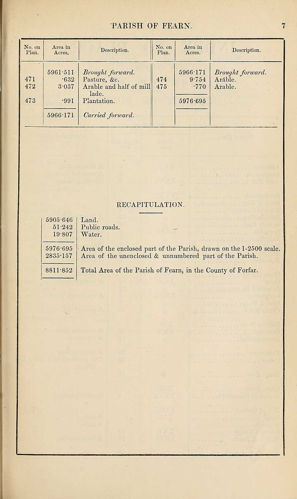
No. on
Plan.
Area in
Acres.
Description.
No. on
Plan.
Area in
Acres.
Description.
471
472
473
5961-511
•632
3-037
•991
5966-171
Brought forward.
Pasture, &c.
Arable and half of mill
lade.
Plantation.
Carried forward.
474
475
5966-171
9-754
•770
5976-695
Brought forward.
Ardble.
Arable.
RECAPITULATION.
5905-646
51-242
19-807
5976-695
2835-157
8811-852
Land.
Public roads.
Water.
Area of the enclosed part of the Parish, drawn on the 1-2500 scale.
Area of the unenclosed & unnumbered part of the Parish.
Total Area of the Parish of Fearn, in the County of Forfar.
7
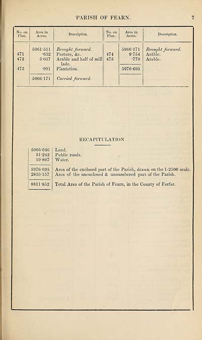
No. on
Plan.
Area in
Acres.
Description.
No. on
Plan.
Area in
Acres.
Description.
471
472
473
5961-511
•632
3-037
•991
5966-171
Brought forward.
Pasture, &c.
Arable and half of mill
lade.
Plantation.
Carried forward.
474
475
5966-171
9-754
•770
5976-695
Brought forward.
Ardble.
Arable.
RECAPITULATION.
5905-646
51-242
19-807
5976-695
2835-157
8811-852
Land.
Public roads.
Water.
Area of the enclosed part of the Parish, drawn on the 1-2500 scale.
Area of the unenclosed & unnumbered part of the Parish.
Total Area of the Parish of Fearn, in the County of Forfar.
Set display mode to:
![]() Universal Viewer |
Universal Viewer | ![]() Mirador |
Large image | Transcription
Mirador |
Large image | Transcription
Images and transcriptions on this page, including medium image downloads, may be used under the Creative Commons Attribution 4.0 International Licence unless otherwise stated. ![]()
| Ordnance Survey Books of Reference 1855-1882 > Eday -- Forfar > (353) Page 7 |
|---|
| Permanent URL | https://digital.nls.uk/99268747 |
|---|
| Attribution and copyright: |
|
|---|---|
| Description | These volumes record acreages of fields and land-use information for each parish in Scotland from 1855-1882. They were compiled with the Ordnance Survey 25 inch to the mile maps for that period, which cover all the inhabited parts of Scotland. Numbered land parcels on these maps, listed consecutively within each parish, are included in the relevant parish Book of Reference. |
|---|---|
| Shelfmark | Map.Ref.C18 |
| Additional NLS resources: | |