Ardisier -- Bellie (part of)
(348) Page 34
Download files
Complete book:
Individual page:
Thumbnail gallery: Grid view | List view
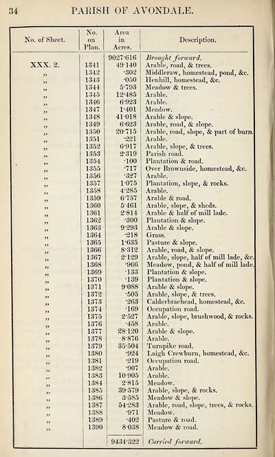
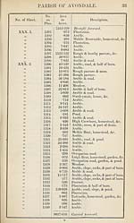
34
PAKISH OF AVONDALE.
No. of Sheet.
No.
on
Plan.
Area
in
Acres.
Description.
XXX. 2.
1341
1342
1343
1344
1345
1346
1347
1348
1349
1350
1351
1352
1353
1354
1355
1356
1357
1358
1359
1360
1361
1362
1363
1364
1365
1366
1367
1368
1369
1370
1371
1372
1373
1374
1375
1376
1377
1378
1379
1380
1381
1382
1383
1384
1385
1386
1387
1388
1389
1390
9027-616
49140
•302
•050
5*793
12*485
6-923
1- 401
41-018
6-623
20-715
•221
6-917
2- 319
•100
•717
•327
1075
4- 285
6757
5- 461
2-814
•300
9- 293
•218
1- 635
8- 312
2129
•966
133
•139
9- 088
•505
•263
•169
2- 527
■458
28-120
8-876
35-504
•924
•219
•907
10- 905
2- 815
39-579
3- 585
54-283
•971
•402
8-038
9434-322
Brought forward.
Arable, road, & trees.
Middleraw, homestead, pond, &c.
Henhill, homestead, &c.
Meadow & trees.
Arable.
Arable.
Meadow.
Arable & slope.
Arable, road, & slope.
Arable, road, slope, & part of burn.
Arable.
Arable, slope, & trees.
Parish road.
Plantation & road.
Over Brownside, homestead, &c.
Arable.
Plantation, slope, & rocks.
Arable.
Arable & road.
Arable, slope, & sheds.
Arable & half of mill lade.
Plantation & slope.
Arable & slope.
Grass.
Pasture & slope.
Arable, road, & slope.
Arable, slope, half of mill lade, &c
Meadow, pond, & half of mill lade
Plantation & slope.
Plantation & slope.
Arable & slope.
Arable, slope, & trees.
Calderbraebead, homestead, &c.
Occupation road.
Arable, slope, brushwood, & rocks
Arable.
Arable & slope.
Arable.
Turnpike road.
Laigh Crewburn, homestead, &c.
Occupation road.
Arable.
Arable.
Meadow.
Arable, slope, & rocks.
Meadow & slope.
Arable, road, slope, trees, & rocks.
Meadow.
Pasture & road.
Meadow & road.
Carried forward.
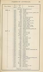
Set display mode to:
![]() Universal Viewer |
Universal Viewer | ![]() Mirador |
Large image | Transcription
Mirador |
Large image | Transcription
Images and transcriptions on this page, including medium image downloads, may be used under the Creative Commons Attribution 4.0 International Licence unless otherwise stated. ![]()
| Ordnance Survey Books of Reference 1855-1882 > Ardisier -- Bellie (part of) > (348) Page 34 |
|---|
| Permanent URL | https://digital.nls.uk/99219223 |
|---|
| Attribution and copyright: |
|
|---|---|
| Description | These volumes record acreages of fields and land-use information for each parish in Scotland from 1855-1882. They were compiled with the Ordnance Survey 25 inch to the mile maps for that period, which cover all the inhabited parts of Scotland. Numbered land parcels on these maps, listed consecutively within each parish, are included in the relevant parish Book of Reference. |
|---|---|
| Shelfmark | Map.Ref.C18 |
| Additional NLS resources: | |