Ardisier -- Bellie (part of)
(347) Page 33
Download files
Complete book:
Individual page:
Thumbnail gallery: Grid view | List view
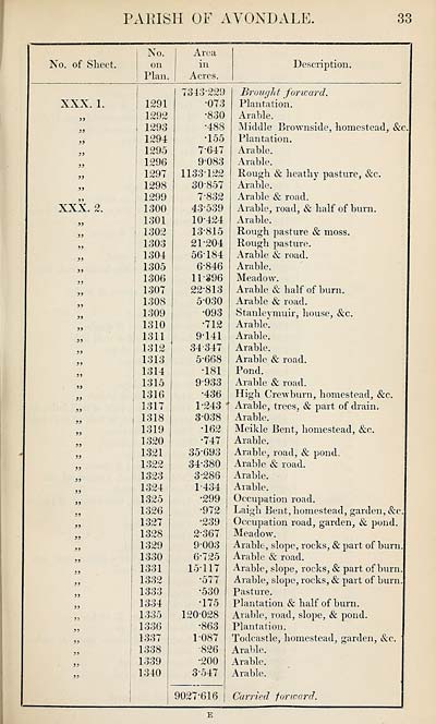
PARISH OF AVONDALE.
33
No. of Sheet.
No.
on
Plan.
Area
in
Acres.
Description.
XXX. 1.
XXX. 2.
1291
1292
1293
1294
1295
1296
1297
1298
1299
1300
1301
1302
1303
1304
1305
1306
1307
1308
1309
1310
1311
1312
1313
1314
1315
1316
1317
1318
1319
1320
1321
1322
1323
1324
1325
1326
1327
1328
1329
1330
1331
1332
1333
1334
1335
1336
1337
1338
1339
1340
7343-229
•073
■830
•488
•155
7-647
9-083
1133-122
30-857
7-832
43-539
10- 424
13-815
21- 204
56184
6-846
11- 396
22- 813
5030
•093
•712
9-141
34- 347
5*668
•181
9933
•436
1-243
3-038
•162
•747
35- 693
34-380
3-286
1- 434
•299
•972
•239
2- 367
9-003
6-725
15-117
•577
•530
•175
120-028
•863
1-087
•826
•200
3- 547
9027-616
Brought forward.
Plantation.
Arable.
Middle Brownside, homestead, &c
Plantation.
Arable.
Arable.
Rough & heathy pasture, &c.
Arable.
Arable & road.
Arable, road, & half of burn.
Arable.
Rough pasture & moss.
Rough pasture.
Arable & road.
Arable.
Meadow.
Arable & half of burn.
Arable & road.
Stanleymuir, house, &c.
Arable.
Arable.
Arable.
Arable & road.
Pond.
Arable & road.
High Crewburn, homestead, &o.
Arable, trees, & part of drain.
Arable.
Meikle Bent, homestead, &c.
Arable.
Arable, road, & pond.
Arable & road.
Arable.
Arable.
Occupation road.
Laigh Bent, homestead, garden, &e
Occupation road, garden, & pond.
Meadow.
Arable, slope, rocks, & part of burn.
Arable & road.
Arable, slope, rocks, & part of burn.
Arable, slope, rocks, & part of burn
Pasture.
Plantation & half of burn.
Arable, road, slope, & pond.
Plantation.
Todcastle, homestead, garden, &c.
Arable.
Arable.
Arable.
Carried forward.
E
Set display mode to:
![]() Universal Viewer |
Universal Viewer | ![]() Mirador |
Large image | Transcription
Mirador |
Large image | Transcription
Images and transcriptions on this page, including medium image downloads, may be used under the Creative Commons Attribution 4.0 International Licence unless otherwise stated. ![]()
| Ordnance Survey Books of Reference 1855-1882 > Ardisier -- Bellie (part of) > (347) Page 33 |
|---|
| Permanent URL | https://digital.nls.uk/99219211 |
|---|
| Attribution and copyright: |
|
|---|---|
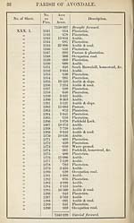
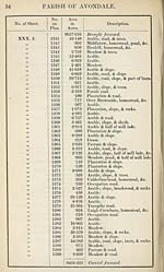
| Description | These volumes record acreages of fields and land-use information for each parish in Scotland from 1855-1882. They were compiled with the Ordnance Survey 25 inch to the mile maps for that period, which cover all the inhabited parts of Scotland. Numbered land parcels on these maps, listed consecutively within each parish, are included in the relevant parish Book of Reference. |
|---|---|
| Shelfmark | Map.Ref.C18 |
| Additional NLS resources: | |