Ardisier -- Bellie (part of)
(327) Page 13
Download files
Complete book:
Individual page:
Thumbnail gallery: Grid view | List view
PARISH OF AVONDALE
13
No. of Sheet.
No.
on
Plan.
Area
in
Acres.
Description.
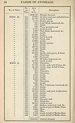
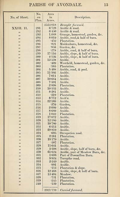
XXIII. 11.
>>
jj
a
291
292
293
294
295
296
297
298
299
300
301
302
303
304
305
306
307
308
309
310
311
312
313
314
315
316
317
318
319
320
321
322
323
324
325
326
327
328
329
330
331
332
333
334
335
336
337
O O Q
ooo
339
340
2534-018
6-728
6- 450
1.668
8-019
•452
•821
•858
•278
17116
4- 126
13-538
•409
•165
5408
11- 566
7011
10-664
7- 591
2-898
10-533
8- 381
•319
8-772
22*189
*370
2- 099
8- 689
1- 042
17- 072
12- 180
10- 780
6-213
29-819
•695
2- 261
18- 179
•587
11- 641
5- 598
61-624
1-698
9- 924
3- 249
•991
•113
12- 468
13- 404
•731
•245
•120
2921-770
Brought forward.
Arable & road.
Arable & road.
Grange, homestead, garden, &c.
Arable, road,& half of burn.
Plantation.
Maidenburn, homestead, &c.
Garden, &c.
Arable, road, & half of burn.
Arable, slope, & half of burn.
Arable, slope, & half of burn.
Arable.
Westfield, homestead, garden, &c.
Plantation.
Arable, road, & pool.
Arable.
Arable.
Arable.
Arable.
Plantation.
Arable.
Arable.
Plantation.
Aralfe.
Arable.
Garden.
Arable.
Arable.
Plantation.
Arable.
Arable.
Arable.
Arable.
Arable.
Occupation road.
Plantation.
Arable.
Plantation.
Arable.
Arable, slope, half of burn, &c.
Arable, part of Meadow Burn, &c.
Part of Powmillon Burn.
Turnpike road.
Arable.
Arable.
Plantation & slope.
Arable, slope, & half of burn.
Meadow.
Plantation.
Plantation.
Plantation.
Carried forward.
13
No. of Sheet.
No.
on
Plan.
Area
in
Acres.
Description.
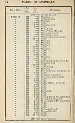
XXIII. 11.
>>
jj
a
291
292
293
294
295
296
297
298
299
300
301
302
303
304
305
306
307
308
309
310
311
312
313
314
315
316
317
318
319
320
321
322
323
324
325
326
327
328
329
330
331
332
333
334
335
336
337
O O Q
ooo
339
340
2534-018
6-728
6- 450
1.668
8-019
•452
•821
•858
•278
17116
4- 126
13-538
•409
•165
5408
11- 566
7011
10-664
7- 591
2-898
10-533
8- 381
•319
8-772
22*189
*370
2- 099
8- 689
1- 042
17- 072
12- 180
10- 780
6-213
29-819
•695
2- 261
18- 179
•587
11- 641
5- 598
61-624
1-698
9- 924
3- 249
•991
•113
12- 468
13- 404
•731
•245
•120
2921-770
Brought forward.
Arable & road.
Arable & road.
Grange, homestead, garden, &c.
Arable, road,& half of burn.
Plantation.
Maidenburn, homestead, &c.
Garden, &c.
Arable, road, & half of burn.
Arable, slope, & half of burn.
Arable, slope, & half of burn.
Arable.
Westfield, homestead, garden, &c.
Plantation.
Arable, road, & pool.
Arable.
Arable.
Arable.
Arable.
Plantation.
Arable.
Arable.
Plantation.
Aralfe.
Arable.
Garden.
Arable.
Arable.
Plantation.
Arable.
Arable.
Arable.
Arable.
Arable.
Occupation road.
Plantation.
Arable.
Plantation.
Arable.
Arable, slope, half of burn, &c.
Arable, part of Meadow Burn, &c.
Part of Powmillon Burn.
Turnpike road.
Arable.
Arable.
Plantation & slope.
Arable, slope, & half of burn.
Meadow.
Plantation.
Plantation.
Plantation.
Carried forward.
Set display mode to:
![]() Universal Viewer |
Universal Viewer | ![]() Mirador |
Large image | Transcription
Mirador |
Large image | Transcription
Images and transcriptions on this page, including medium image downloads, may be used under the Creative Commons Attribution 4.0 International Licence unless otherwise stated. ![]()
| Ordnance Survey Books of Reference 1855-1882 > Ardisier -- Bellie (part of) > (327) Page 13 |
|---|
| Permanent URL | https://digital.nls.uk/99218971 |
|---|
| Attribution and copyright: |
|
|---|---|
| Description | These volumes record acreages of fields and land-use information for each parish in Scotland from 1855-1882. They were compiled with the Ordnance Survey 25 inch to the mile maps for that period, which cover all the inhabited parts of Scotland. Numbered land parcels on these maps, listed consecutively within each parish, are included in the relevant parish Book of Reference. |
|---|---|
| Shelfmark | Map.Ref.C18 |
| Additional NLS resources: | |