Ardisier -- Bellie (part of)
(326) Page 12
Download files
Complete book:
Individual page:
Thumbnail gallery: Grid view | List view
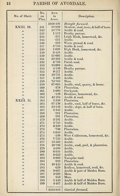
12
PARISH OF AVONDALE
No. of Sheet.
No.
on
Plan.
Area
in
Acres.
Description.
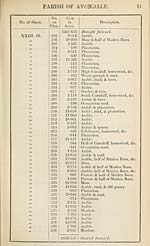
XXIII. 10.
a
a
a
fi
>)
3>
33
33
33
33
33
33
33
33
33
33
33
33
XXIII. 11.
33
33
33
33
33
33
33
33
33
33
33
33
33
33
33
33
33
33
33
33
33
33
33
33
33
241
242
243
244
245
246
247
248
219
250
251
252
253
254
255
256
257
258
259
260
261
262
263
264
265
266
267
268
269
270
271
272
273
274
275
276
277
278
279
280
281
282
283
284
285
286
287
288
289
290
1920-346
18- 909
13-770
1-112
•321
•251
•318
8- 735
1- 098
6-428
11-602
39-283
6- 710
15-093
4- 150
9- 117
19- 731
5 589
73-763
97-065
•378
1-086
•129
42-104
5- 326
97-156
23-146
8- 345
•281
•191
2- 191
5- 745
3- 330
•750
1-045
•530
7- 732
13-562
10-786
4- 689
6- 934
6-653
8- 000
•223
10-442
•628
9- 067
3- 908
•353
1-450
4- 467
2534-018
Brought forward.
Meadow, road, trees, & half of burn.
Arable & road.
Heathy pasture.
Laigh Hook, homestead, &c.
Arable.
Waste ground & road.
Arable & road.
High Hook, homestead, &c.
Arable.
Arable.
Arable & road.
Parish road.
Arable.
Heathy pasture.
Arable.
Arable.
Arable.
Moss.
Arable, road, quarry, & house.
Plantation.
Stackyard.
Hooklaw, homestead, &c.
Arable & road.
Plantation.
Arable, road, half of burns, &c.
Arable, slope, & half of burn.
Arable.
Plantation.
Plantation.
Arable.
Arable.
Arable.
Plantation.
Arable.
West Coldstream, homestead, &c.
Arable.
Arable.
Arable, road, pool, & plantation.
Arable.
Arable.
Arable.
Turnpike road.
Plantation.
Arable & road.
Iledlees, homestead, road, &c.
Arable & part of Maiden Burn.
Moss.
Moss.
Arable & half of Maiden Burn.
Arable & half of Maiden Burn.
Carried forward.
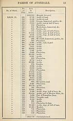
PARISH OF AVONDALE
No. of Sheet.
No.
on
Plan.
Area
in
Acres.
Description.
XXIII. 10.
a
a
a
fi
>)
3>
33
33
33
33
33
33
33
33
33
33
33
33
XXIII. 11.
33
33
33
33
33
33
33
33
33
33
33
33
33
33
33
33
33
33
33
33
33
33
33
33
33
241
242
243
244
245
246
247
248
219
250
251
252
253
254
255
256
257
258
259
260
261
262
263
264
265
266
267
268
269
270
271
272
273
274
275
276
277
278
279
280
281
282
283
284
285
286
287
288
289
290
1920-346
18- 909
13-770
1-112
•321
•251
•318
8- 735
1- 098
6-428
11-602
39-283
6- 710
15-093
4- 150
9- 117
19- 731
5 589
73-763
97-065
•378
1-086
•129
42-104
5- 326
97-156
23-146
8- 345
•281
•191
2- 191
5- 745
3- 330
•750
1-045
•530
7- 732
13-562
10-786
4- 689
6- 934
6-653
8- 000
•223
10-442
•628
9- 067
3- 908
•353
1-450
4- 467
2534-018
Brought forward.
Meadow, road, trees, & half of burn.
Arable & road.
Heathy pasture.
Laigh Hook, homestead, &c.
Arable.
Waste ground & road.
Arable & road.
High Hook, homestead, &c.
Arable.
Arable.
Arable & road.
Parish road.
Arable.
Heathy pasture.
Arable.
Arable.
Arable.
Moss.
Arable, road, quarry, & house.
Plantation.
Stackyard.
Hooklaw, homestead, &c.
Arable & road.
Plantation.
Arable, road, half of burns, &c.
Arable, slope, & half of burn.
Arable.
Plantation.
Plantation.
Arable.
Arable.
Arable.
Plantation.
Arable.
West Coldstream, homestead, &c.
Arable.
Arable.
Arable, road, pool, & plantation.
Arable.
Arable.
Arable.
Turnpike road.
Plantation.
Arable & road.
Iledlees, homestead, road, &c.
Arable & part of Maiden Burn.
Moss.
Moss.
Arable & half of Maiden Burn.
Arable & half of Maiden Burn.
Carried forward.
Set display mode to:
![]() Universal Viewer |
Universal Viewer | ![]() Mirador |
Large image | Transcription
Mirador |
Large image | Transcription
Images and transcriptions on this page, including medium image downloads, may be used under the Creative Commons Attribution 4.0 International Licence unless otherwise stated. ![]()
| Ordnance Survey Books of Reference 1855-1882 > Ardisier -- Bellie (part of) > (326) Page 12 |
|---|
| Permanent URL | https://digital.nls.uk/99218959 |
|---|
| Attribution and copyright: |
|
|---|---|
| Description | These volumes record acreages of fields and land-use information for each parish in Scotland from 1855-1882. They were compiled with the Ordnance Survey 25 inch to the mile maps for that period, which cover all the inhabited parts of Scotland. Numbered land parcels on these maps, listed consecutively within each parish, are included in the relevant parish Book of Reference. |
|---|---|
| Shelfmark | Map.Ref.C18 |
| Additional NLS resources: | |