

Medicine - Disease > Report of an investigation in regard to the prevalence of stegomyia and other mosquitoes in Karachi, and the measures necessary for their control
(17) Page 3
Download files
Individual page:
Thumbnail gallery: Grid view | List view
3
CHAPTER II.
BRIEF DESCRIPTION OF KARACHI.
Section 1.
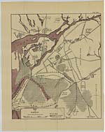
1. Karchi the capital and the chief city of the province of Sind
is situated nearly at the apex of the Arabian Sea in 24.27' N. Latitude and 66.58' E. Longitude.
It is the third in importance of all the sea-ports of British India and is the natural outlet of the trade for Sind and Punjb. It is the sea-board terminus of the great railway system of the North-West, as far as Peshawar in the north and round to Delhi in the east. The present importance of the port is due to its being the nearest point of disembarkation, being 200 miles nearer to Aden than Bombay, and may in future become the point of junction of the main lines of railway to Europe.
2. Physical aspects.-The area within municipal limits comprises nearly 74 square miles and includes large areas of waste and dry lands and rocky grounds, absolutely useless, and covered at certain seasons only by water. The aspect of the surrounding district is hilly excepting that bordering on the sea. Ranges of hills, lofty and barren, are found running from north to south with deep wide valleys between. After heavy falls of rain these afford good pasturage.
The area of Karchi, qu town, is much more limited, being only 5 square miles, and is in the shape of a triangle with its apex at the Custom House and the base formed by a line from the Cantonment Station to the Government gardens. Kiamari, with its long line of wharves, forms an entirely separate district, separated from the mainland by a narrow creek (the China creek), the village being two miles away from the city. Manora, Baba and Bhit are islands facing the long line of wharves and have constant communication with the mainland across the basin. On the north and the west a shallow break-water spreads out, through which runs the one river " Lyari " and a number of creeks connected with it. When heavy rain falls in the hills, the river flows with water; but this occurs only for a few days of the year and generally it is perfectly dry. The creeks are fringed with mangrove bushes, and drain the marshy ground and mud flats which are covered with water at high tide. The tidal waters of the creek have a scouring effect, and some of the mangrove swamps are almost entirely submerged twice a day.
3. Hydrography.-The canals of the district are all in the Indus Delta which extends from Ghizri to Ghar, 125 miles distant. The supply of water to the city is obtained from two wells on the Malir river 16 miles away, and is thence conducted by conduits into a distributing reservoir. The tanks in the city are all filled up. There are 271 wells in the city, none being found in the Civil Lines and at Kiamari which is the harbour proper. There are 230 wells in the Lyari division which is a suburban village extending beyond the Lyari river.
4. The town is not much above the mean sea-level, the greater part of it being from 5 to 7 feet above that level, while the Civil Lines are from 10 to 30 feet upwards. The marshy areas to the west of these and beyond Queen's Road are low-lying waste lands where the sea-water rushes in at spring tides and forms shallow pools.
5. The vegetation is characteristic of a rainless climate, dry atmosphere and a sandy soil impregnated with salts. Babul and milkbush are only seen and there are no jungles round about. There is little natural undergrowth. A great portion of the land on the east side-the Garden quarter-is under cultivation, a majority of them being market gardens.
Section 2.
1. Climatic data.-The climate of Karchi resembles more nearly that
of Bombay, in temperature, humidity and equability. The average mean annual temperature is 77.5 F.,
CHAPTER II.
BRIEF DESCRIPTION OF KARACHI.
Section 1.
1. Karchi the capital and the chief city of the province of Sind
is situated nearly at the apex of the Arabian Sea in 24.27' N. Latitude and 66.58' E. Longitude.
It is the third in importance of all the sea-ports of British India and is the natural outlet of the trade for Sind and Punjb. It is the sea-board terminus of the great railway system of the North-West, as far as Peshawar in the north and round to Delhi in the east. The present importance of the port is due to its being the nearest point of disembarkation, being 200 miles nearer to Aden than Bombay, and may in future become the point of junction of the main lines of railway to Europe.
2. Physical aspects.-The area within municipal limits comprises nearly 74 square miles and includes large areas of waste and dry lands and rocky grounds, absolutely useless, and covered at certain seasons only by water. The aspect of the surrounding district is hilly excepting that bordering on the sea. Ranges of hills, lofty and barren, are found running from north to south with deep wide valleys between. After heavy falls of rain these afford good pasturage.
The area of Karchi, qu town, is much more limited, being only 5 square miles, and is in the shape of a triangle with its apex at the Custom House and the base formed by a line from the Cantonment Station to the Government gardens. Kiamari, with its long line of wharves, forms an entirely separate district, separated from the mainland by a narrow creek (the China creek), the village being two miles away from the city. Manora, Baba and Bhit are islands facing the long line of wharves and have constant communication with the mainland across the basin. On the north and the west a shallow break-water spreads out, through which runs the one river " Lyari " and a number of creeks connected with it. When heavy rain falls in the hills, the river flows with water; but this occurs only for a few days of the year and generally it is perfectly dry. The creeks are fringed with mangrove bushes, and drain the marshy ground and mud flats which are covered with water at high tide. The tidal waters of the creek have a scouring effect, and some of the mangrove swamps are almost entirely submerged twice a day.
3. Hydrography.-The canals of the district are all in the Indus Delta which extends from Ghizri to Ghar, 125 miles distant. The supply of water to the city is obtained from two wells on the Malir river 16 miles away, and is thence conducted by conduits into a distributing reservoir. The tanks in the city are all filled up. There are 271 wells in the city, none being found in the Civil Lines and at Kiamari which is the harbour proper. There are 230 wells in the Lyari division which is a suburban village extending beyond the Lyari river.
4. The town is not much above the mean sea-level, the greater part of it being from 5 to 7 feet above that level, while the Civil Lines are from 10 to 30 feet upwards. The marshy areas to the west of these and beyond Queen's Road are low-lying waste lands where the sea-water rushes in at spring tides and forms shallow pools.
5. The vegetation is characteristic of a rainless climate, dry atmosphere and a sandy soil impregnated with salts. Babul and milkbush are only seen and there are no jungles round about. There is little natural undergrowth. A great portion of the land on the east side-the Garden quarter-is under cultivation, a majority of them being market gardens.
Section 2.
1. Climatic data.-The climate of Karchi resembles more nearly that
of Bombay, in temperature, humidity and equability. The average mean annual temperature is 77.5 F.,
Set display mode to: Large image | Zoom image | Transcription
Images and transcriptions on this page, including medium image downloads, may be used under the Creative Commons Attribution 4.0 International Licence unless otherwise stated. ![]()
| Permanent URL | https://digital.nls.uk/74572924 |
|---|---|
| Description | Chapter II.: Brief description of Karachi |
| Description | Includes yellow fever introduction, descriptions of Karachi and mosquitoes of Karachi. Also preventive measures. Includes maps. |
|---|---|
| Shelfmark | IP/13/SB.2 |
| Additional NLS resources: | |
| Description | The Disease collection consists of 51 volumes from British India, dating from 1868 to 1920. Official publications varying from short reports to multi-volume histories related to disease, public health and medical research. Focuses on cholera, leprosy, plague and malaria. |
|---|---|
| Description | The India Papers collection contains publications of the central (Imperial) Government and many Indian states. Most states came under British rule. Much of the collection dates from between the post-Mutiny re-organisation of the Indian Government and Indian Independence in 1947. Some items published in London by John Murray. |
|---|---|
| Shelfmark | India Papers |