Imperial gazeteer of Scotland, or, Dictionary of Scottish topography > Volume 1
(740) Page 612 - ERI
Download files
Complete book:
Individual page:
Thumbnail gallery: Grid view | List view

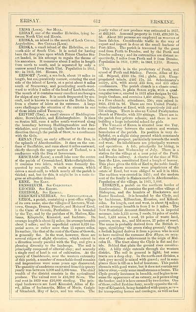
ERISAY.
612
ERSKINE.
ERISA (Loch). See Mull.
ERISAY, one of the smaller Hebrides, lying be-
tween North Uist and Harris.
ERISKA, an island in the mouth of Loch Creran,
Argyleshire. See Ceekak (Loch) .
ERISKA, a small island of the Hebrides, on the
south side of South Uist. It is noted for having
been the first place upon which Prince Charles Stu-
art landed, in his attempt to regain the throne of
his ancestors. It measures about 3 miles in length
from north to south, and is separated by only a
narrow sound from South Uist. Population in 1841,
80 ; in 1881, 396. Houses, 79.
ERISORT (Loch), a sea-loch, about 10 miles in
length, but comparatively narrow, entering the east
side of the island of Lewis, at a point about 8 miles
south of Stornoway, and penetrating south-west-
ward to within 2 miles of the head of Loch Seaforth.
The mouth of it contains many excellent anchorages
for ships of any size. It is much frequented by sea-
craft, and is known to mariners as the Barkin Isles,
from a cluster of islets at its entrance. A large
cave challenges the attention of the curious in one
of these islets called Tanneray.
ERIVIST (The), a small stream of Haddington-
shire, Berwickshire, and Edinburghshire. It rises
on Soutra hill, runs 4 miles south-westward along
the boundary between Haddingtonshire and Ber-
wickshire, and proceeds 1J mile farther in the same
direction through the parish of Stow, to a confluence
with the Gala.
ERNAN (The), an early affluent of the Don, in
the uplands of Aberdeenshire. It rises on the con-
fines of Banffshire, and runs about 6 miles eastward,
chiefly through the upper section of Tarland, to a
confluence with the Don at Inverernan.
ERNCRAGS (Loch), a small lake near the centre
of the parish of Crossmichael, Kirkcudbrightshire.
It contains two islets, which were formerly fre-
quented by sea-gulls. It emits a stream, which
drives a meal-mill, to which nearly all the parish is
thirled; and, but for this, it might be in a main de-
gree or altogether drained.
ERNE. See Earn.
ERNSHEUCH. See Coldixgham.
EROCHD. See Ebicht.
ERRIBOLL. See Eeiboll.
ERRICKSTANEBRAE. See Eeickstanebeae.
ERROL, a parish, containing a post-office village
of its own name, also the villages of Leetown, West-
town, Grange, Drums, Pitrodie, and Mains of Errol,
in the Carse of Gowrie, Perthshire. It is bounded
by the Tay, and by the parishes of St. Madoes, Kin-
fauns, Kilspindie, Kinnaird, and Inchture. Its
average length is about 5J miles; its average breadth
about 3 miles ; and its superficial extent 8,626 im-
perial acres, or rather more than 15 square miles.
Its surface, like that of the restof the Carse of Gowrie,
is generally flat. In the west, however, there are
several ridges of slight elevation, which extend in
a direction nearly parallel with the Tay, and give a
pleasing diversity to the landscape. The soil is
principally composed of alluvial clay; and scarcely
a single rood of land is out of cultivation. At the
quarry of Clashbennie, near the western extremity
of this parish, a number of remarkable fossil remains
and impressions were some years ago discovered.
The quantity of sandstone excavated from this quarry
yearly was between 4,000 and 5,000 tons. The chief
wealth of the district consists in the agricultural
produce. The valued rent is £16,982 Scots. The
real rent in 1829 was £26,000 sterling. The prin-
cipal landowners are Lord Kinnaird, Allan of Er-
rol, Allan of Inchmartin, Milne of Murie, Craigie
of Glcndoick, Hay of Leys, and ten others. The
yearly value of raw produce was estimated in 1837,
at £63,940. Assessed property in 1843, £20,260 5s.
6d. About 300 persons are employed as weavers of
linen fabrics. Considerable traffic in the way of
export and import is done at the small harbour of
Port-Allen. The parish is traversed by the great
road from Perth to Dundee, and by the Perth and
Dundee railway; and its extremities are distant re-
spectively, 7 miles from Perth and 9 from Dundee.
Population in 1831, 2,992 ; in 1861, 2,759. Houses
576.
This parish is in the presbytery of Perth, and
synod of Perth and Stirling. Patron, Allan of Er-
rol. Stipend, £310 13s. lOd. ; glebe, £18. Unap-
propriated teinds, £407 17s. 5d. Schoolmaster's
salary, £34, with about £35 fees, and £25 other
emoluments. The parish church is a chaste cruci-
form structure, in plain Saxon style, with a quad-
rangular tower, erected in 1831 after designs by Gil-
lespie Graham, and contains 1,450 sittings. There
is a Free church: attendance, 250; sum raised in
1854, £195 Is. 9d. There are two United Presby-
terian churches at Errol, with respectively 242 and
751 sittings. There is also an United Presbyterian
church at Pitrodie, with 320 sittings. There are in
the parish four private schools; and there is now
bmlding a large industrial school for girls.
The Village of Eerol is situated near the Tay,
about half-way between the eastern and western
boundaries of the parish. Its position is very de-
lightful, on a slight rising ground which commands
a delightful prospect, particularly towards the south
and west. Its inhabitants are principally weavers
and operatives. A fair, principally for hiring, is
held on the last Wednesday of Jul}'. There is a
station for the village at a near point of the Perth
and Dundee railway. A charter of the time of Wil-
liam the Lion, constituted Errol a burgh of barony.
This place gives the title of Earl to_the noble family
of Hay; whose ancestors were proprietors of the
estate of Errol, but were obliged to sell it in 1634.
The earldom was created in 1452; and the modern
seat of the family is Slaines castle in Aberdeenshire.
Population of the village, in 1861, 1,0S6.
ERSKINE, a parish on the northern border of
Renfrewshire. It contains the post-office village of
Bishopton, and the hamlets of Blackstown and
Easter Rossland. It is bounded by the Clyde, and
by Inchinnan, Kilbarchan, Houston, and Kilmal-
colm. Its length, east and west, is about 8 J miles ;
and its average breadth is from 2 to 3 miles. The
New Statistical Account distributes it, in imperial
measure, into 5,121 acres, 2 roods, 24 poles of arable
land, 1,431 acres, 1 rood, 28 poles of waste land,
pasture, moss, &c, and 554 acres, 27 poles of wood.
The name is probably derived from the British ir-
isgyn, signifying ' the green rising ground;' though
a foolish legend derives it from a person who is said
to have received the surname Eris Skyne, on occa-
sion of a military achievement in the reign of Mal-
colm II. The tract along the Clyde is flat and fer-
tile. Behind that plain the ground rises consider-
ably. A hilly ridge extends through the western
district. The soil in general is light; but some
tracts are a deep clay. In the north-east division, a
dark grey mould is mixed with gravel ; and in some
places there is till on a bed of freestone. This parish
abounds with good water, but it does not contain any
lake or river, — only some small streams or burns. The
Clyde greatly increases in breadth, and begins to as-
sume the appearance of an estuary, as it passes along
the border ; and it is here crossed by two ferries. One
of these, called Erskine ferry, nearly opposite the vil-
lage of Kilpatrick, being furnished with quays, serv°s
for transporting horses and carriages, as well as foot
Set display mode to: Large image | Transcription
Images and transcriptions on this page, including medium image downloads, may be used under the Creative Commons Attribution 4.0 International Licence unless otherwise stated. ![]()
| Gazetteers of Scotland, 1803-1901 > Imperial gazeteer of Scotland, or, Dictionary of Scottish topography > Volume 1 > (740) Page 612 - ERI |
|---|
| Permanent URL | https://digital.nls.uk/97468010 |
|---|
| Description | Volume I: Aan-Gordon. |
|---|---|
| Attribution and copyright: |
|

