Download files
Complete book:
Individual page:
Thumbnail gallery: Grid view | List view

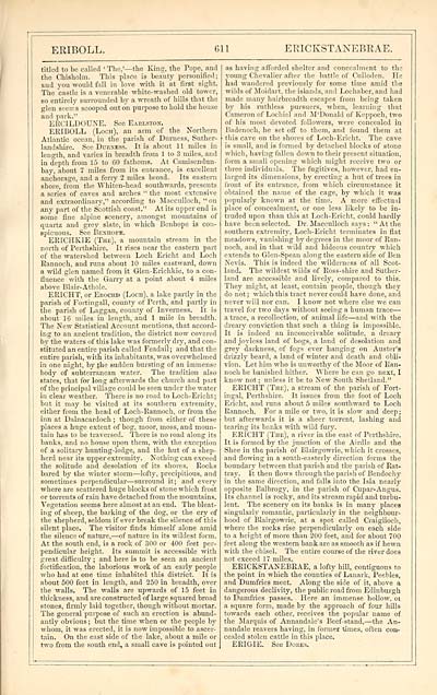
ERIBOLL.
611
ER1CKSTANEBRAE.
titled to be called ' The,'— the King, the Pope, and
the Chisholm. This place is beauty personified;
and you would fall in love with it at first sight.
The castle is a venerable white-washed old tower,
so entirely surrounded by a wreath of hills that the
glen seenis scooped out o'n purpose to hold the house
and park."
ERCILDOUNE. See Earlston.
ERIBOLL (Loch), an arm of the Northern
Atlantic ocean, in the parish of Durness, Suther-
landshire. See Duexess. It is about 11 miles in
length, and varies in breadth from 1 to 3 miles, and
in depth from 15 to 60 fathoms. At Camisendun-
bay, about 7 miles from its entrance, is excellent
anchorage, and a ferry 2 miles broad. Its eastern
shore, from the Whiten-head southwards, presents
a series of caves and arches " the most extensive
and extraordinary," according to Macculloch, "on
any part of the Scottish coast." At its upper end is
some fine alpine scenery, amongst mountains of
quartz and grey slate, in which Benhope is con-
spicuous. See Benhope.
ERICHKIE (The), a mountain stream in the
north of Perthshire. It rises near the eastern part
of the watershed between Loch Ericht and Loch
Rannoch, and runs about 10 miles eastward, down
a wild glen named from it Glen-Erichkie, to a con-
fluence with the Garry at a point about 4 miles
above Blair- Athole.
ERICHT, or Erochd (Loch), a lake partly in the
parish of Fortingall, county of Perth, and partly in
the parish of Laggan, county of Inverness. It is
about 16 miles in length, and 1 mile in breadth.
The New Statistical Account mentions, that accord-
ing to an ancient tradition, the district now covered
by the waters of this lake was formerly dry, and con-
stituted an entire parish called Feadail; and that the
entire parish, with its inhabitants, was overwhelmed
in one night, by the sudden bursting of an immense
body of subterranean water. The tradition also
states, that for long afterwards the church and part
of the principal village could be seen under the water
in clear weather. There is no road to Loch-Ericht;
but it may be visited at its southern extremity,
either from the head of Loch-Rannoch, or from the
inn at Dalnacardoch ; though from either of these
places a huge extent of bog, moor, moss, and moun-
tain has to be traversed. There is no road along its
banks, and no house upon them, with the exception
of a solitary hunting-lodge, and the hut of a shep-
herd near its upper extremity. Nothing can exceed
the solitude and desolation of its shores. Rocks
bared by the winter storm — lofty, precipitious, and
sometimes perpendicular — surround it; and every
where are scattered huge blocks of stone which frost
or torrents of rain have detached from the mountains.
Vegetation seems here almost at an end. The bleat-
ing of sheep, the barking of the dog, or the cry of
the shepherd, seldom if ever break the silence of this
silent place. The visitor finds himself alone amid
the silence of nature, — of nature in its wildest form.
At the south end, is a rock of 300 or 400 feet per-
pendicular height. Its summit is accessible with
great difficulty ; and here is to be seen an ancient
fortification, the laborious work of an early people
who had at one time inhabited this district. It is
about 500 feet in length, and 250 in breadth, over
the walls. The walls are upwards of 15 feet in
thickness, and are constructed of large squared broad
stones, firmly laid together, though without mortar.
The general purpose of such an erection is abund-
antly obvious ; but the time when or the people by
whom, it was erected, it is now impossible to ascer-
tain. On the east side of the lake, about a mile or
two from the south end, a small cave is pointed out
as having afforded shelter and concealment to the
young Chevalier after the battle of Culloden. He
had wandered previously for some time amid the
wilds of Moidart. the islands, and Lochaber, and had
made many hairbreadth escapes from being taken
by his ruthless pursuers, when, learning that
Cameron of Lochiel and M'Donald of Keppoch, two
of his most devoted followers, were concealed in
Badenoch, he set off to them, and found them at
this cave on the shores of Loch-Ericht. The cave
is small, and is formed by detached blocks of stone
which, having fallen down to their present situation,
form a small opening which might receive two or
three individuals. The fugitives, however, had en-
larged its dimensions, by erecting a hut of trees in
front of its entrance, from which circumstance it
obtained the name of the cage, by which it was
popularly known at the time. A more effectual
place of concealment, or one less likely to be in-
truded upon than this at Loch-Ericht, could hardly
have been selected. Dr. Macculloch says : "At the
southern extremity, Loch-Ericht terminates in flat
meadows, vanishing by degrees in the moor of Ran-
noch, and in that wild and hideous countiy which
extends to Glen-Spean along the eastern side of Ben
Nevis. This is indeed the wilderness of all Scot-
land. The wildest wilds of Ross-shire and Suther-
land are accessible and lively, compared to this.
They might, at least, contain people, though they
do not ; which this tract never could have done, and
never will nor can. I know not where else we can
travel for two days without seeing a human trace —
a trace, a recollection, of animal life — and with the
dreary conviction that such a thing is impossible.
It is indeed an inconceivable solitude, a dreary
and joyless land of bogs, a land of desolation and
grey darkness, of fogs ever hanging on Auster'a
drizzly beard, a land of winter and death and obli-
vion. Let him who is unworthy of the Moor of Ran-
noch be banished hither. \Yhere he can go next, I
know not ; unless it be to New South Shetland."
ERICHT (The), a stream of the parish of Fort-
ingal, Perthshire. It issues from the foot of Loch
Ericht, and runs about 5 miles southward to Loch
Rannoch. For a mile or two, it is slow and deep ;
but afterwards it is a sheer torrent, lashing and
tearing its banks with wild fury.
ERICHT (The), a river in the east of Perthshire.
It is formed by the junction of the Airdle and the
Shee in the parish of Blairgowrie, which it crosses,
and flowing in a south-easterly direction forms the
boundary between that parish and the parish of Rat-
tray. It then flows through the parish of Bendochy
in the same direction, and falls into the Isla nearly
opposite Balbrogy. in the parish of Cupar-Angus.
Its channel is rocky, and its stream rapid and turbu-
lent. The scenery on its banks is in many places
singularly romantic, particularly in the neighbour-
hood of Blairgowrie, at a spot called Craiglioeh,
where the rocks rise perpendicularly on each side
to a height of more than 200 feet, and for about 700
feet along the western bank are as smooth as if hewn
with the chisel. The entire course of the river does
not exceed 17 miles.
ERICKSTANEBRAE, a lofty hill, contiguous to
the point in which the counties of Lanark, Peebles,
and Dumfries meet. Along the side of it, above a
dangerous declivity, the public road from Edinburgh
to Dumfries passes. Here an immense hollow, ot
a square form, made by the approach of four hills
towards each other, receives the popular name of
the Marquis of Annandale's Beef-stand, — the An-
nandale reavers having, in former times, often con-
cealed stolen cattle in this place.
ERIGIE. See Dores.
Set display mode to: Large image | Transcription
Images and transcriptions on this page, including medium image downloads, may be used under the Creative Commons Attribution 4.0 International Licence unless otherwise stated. ![]()
| Gazetteers of Scotland, 1803-1901 > Imperial gazeteer of Scotland, or, Dictionary of Scottish topography > Volume 1 > (739) Page 611 |
|---|
| Permanent URL | https://digital.nls.uk/97467998 |
|---|
| Description | Volume I: Aan-Gordon. |
|---|---|
| Attribution and copyright: |
|

