Ordnance gazetteer of Scotland
(1420) Page 1412
Download files
Complete book:
Individual page:
Thumbnail gallery: Grid view | List view

ROXBURGHSHIRE
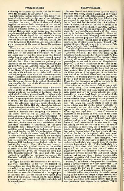
a tributary of the Hermitage Water, and can be traced
across the watershed to the Tarras Water.
An interesting feature connected with this develop-
ment of volcanic rocks at the base of the Calciferous
Sandstones, is the number of necks or volcanic orifices
throughout the county. Some of these undoubtedly
supplied the volcanic rocks belonging to this horizon,
while others probably acted as blowholes for the dis-
charge of triturated materials. An excellent example
occurs at Melrose, and in the quarry near the station
there is a capital section of the material filling the vent.
A glance at the Geological Survey maps of the county
(sheets 11, 25, 26 of the 1-inch map) will show the dis-
tribution of these old centres of eruption. Black Law,
Down Law, Dunian Hill, Rubers Law, the Maiden Paps,
are all examples of the cores of Lower Carboniferous
Cones.
There are two areas of Carboniferous rocks in the
county — one in the extreme NE part, extending from
near Kelso to the Merse of Berwickshire; the other,
and larger area of the two, runs along the English
border from a point where the road crosses from Jed-
burgh to Redesdale, to near the junction of the Liddel
with the Esk. The latter covers the greater part of
Liddesdale and the surrounding heights, culminating in
the Peel, Carter, and Larriston Fells. In the former
area, the strata form the rim of the Carboniferous basin
of the Merse of Berwickshire. As already indicated,
they overlie the volcanic belt at Kelso, and consist of
blue, red, and green clays, white and blue cement-stones,
flaggy sandstones, and occasional bands of calcareous
conglomeratic sandstone, dipping away at gentle angles
from the ancient lavas. It is evident, therefore, that
they resemble the type of the Cement-stone series as
developed in Midlothian.
The relations of the Carboniferous rocks of Liddesdale
to those in the N of England will be discussed in the
general article on the geology of Scotland. Even in
this limited area there are considerable variations in the
order of succession of the strata when traced along the
strike. Beginning with the section in Lower Liddesdale
we find that the beds overlying the volcanic zone at the
base of the Calciferous Sandstones consist of sandstones,
well seen on the Whita Hill above Langholm, followed
by cement-stones consisting of blue and green clays,
shales, and calcareous sandstones. Near Newcastleton
there is a volcanic zone occupying the horizon of
the famous scorpion bed at Langholm. (See the
geological section in the article Dumfriesshire.) A
second horizon of slaggy basalt occurs a little higher up
in the series, just above the lowest beds of the Fell
Sandstones, which form the next subdivision of the
Calciferous Sandstones of Liddesdale. In the lower
districts the base of this group is represented by a coarse
sandstone seen at Kershope Foot, thickening out towards
the E, and forming the Kidd's Linn Sandstone of Upper
Liddesdale. The basalt zone of Caerby Hill comes next
in order, followed by strata resembling the underlying
Cement-stone group, with a band of fine tuff and some
thin coal seams, the whole series being overlain by the
Larriston Fell Sandstones— the highest beds in this
part of the county. Along this horizon, however,
to the W there is a gradual increase in the number
of bands of marine limestone, the equivalents of the
Penton Limestone group, and perhaps the lower part
of the Canonbie Coalfield. The upper part of the latter
coalfield is probably on the same horizon as the
Plashetts Coalfield, which is high up in the Fell Sand-
stone group.
In Upper Liddesdale the succession is not so varied.
The white sandstones at the base are replaced by
cement-stones and clays, the whole of the upper part of
the valley being carved out of these strata, ana they
are also traceable high up on the flanks of Peel Fell.
Thick beds of sandstone alternate with the upper part
of the series, and these are overlain by the great group
of the Fell Sandstones. Underneath the latter there is
a thin seam of coal, the outcrop of which can be followed
for some distance.
1412
ROXBURGHSHIRE
Between Hawick and Selkirk some dykes of minette
and mica trap occur, having a NNE and SSW trend,
which are only found in the Silurian rocks. As they do
not pierce any rocks later than the Upper Silurian, they
are supposed to have been intruded either during Lud-
low or Lower Old Red Sandstone time. Pink felsite is
found in dykes, and also in the form of sheets, as in
the Eildons and the black Hill of Earlston. As these
sheets penetrate the Silurian and Upper Old Red Sand-
stone, they are probably associated with the volcanic
activity in the Lower Carboniferous period. Sheets and
masses of intrusive basalt belonging to the same period
occur, and bosses of porphyrite are also associated with
the volcanic orifices. Basalt dykes of Tertiary age are
met with, one of which crosses the county from E to W,
passing through Hawick, where it is known as 'the
Yetlan dyke' (i.e., Cast Iron dyke).
The glacial phenomena of the Border county will be
discussed in the general articleon the geology of Scotland.
Economic Minerals.- — The calcareous bands in the
Calciferous Sandstone series have been wrought for lime
in Liddesdale, as, for instance, at Thorlieshope. Some
of them yield an excellent marine cement, but those at
present quarried are used for mortar and for agricultural
purposes. The white sandstones at the base of the
series in Lower Liddesdale form an excellent building
stone. The coarse sandstone at Kershope Foot has also
been worked. One of the thick beds of sandstone in
the Cement-stones of the upper part of the basin has
been worked at the Dead Water, and has been exten-
sively used for building purposes in the Border towns.
In the E part of the county the harder bands of the
Upper Old Red formation, as well as the grits in the
Silurian series, are used for similar purposes.
Soil. — The soil of the arable lands is partly light
and partly heavy. The former consists of rich loam,
or of mixtures of sand and loam, gravel and loam, or
sand, gravel, and clay, on various subsoils, and occurs
generally on low or level lands in the vales of the
streams. In some cases it is also found on eminences
of considerable height, especially in the parishes of
Linton, Eckford, Crailing, Ancrum, Maxton, and Mel-
rose. The heavy soil consists chiefly of clay or clay
mixtures lying upon till or other retentive subsoils. It
occurs mostly on the high arable lands ; it rarely
appears in the valleys except on a dry bottom or
alternating with light soil. It forms a considerable
aggregate in the parishes on both sides of the Tweed
around Kelso; it covers an area 10 miles by 4, com-
prising nearly all Bowden, Lilliesleaf, and Minto
parishes, and parts of the parishes on the northern
border of these. Over one-half of that area it is deep
and fertile; but over the other it is cold and shallow
and uncertain in production, and is therefore largely
devoted to plantation. The pastoral lands have either
dry, wet, or heathy soils. The first prevails all east-
ward of the Jed, is interspersed with some small
patches of heath and a few small drained marshes, and
in general has a thick sward of rich sweet grass. Wet
soil prevails from the SW skirts of Ruberslaw to the
confines of Liddesdale, and consists there of stubborn
clay upon impenetrable till. Within Liddesdale it is
extensively intermixed with heath ; and in all the
region SW of the Jed, or from the SW skirts of
Ruberslaw to the SW extremity of Liddesdale, it is
prevailingly so wet as to render the land almost entirely
pastoral. At the same time it isolates a considerable
aggregate proportion of dry land, and includes spongy
fields susceptible of great improvement by draining.
Climate. — The climate is temperate, but the eastern
border is in winter exposed to violent snowstorms. The
most copious rainfall in the county occurs in the moun-
tains towards the SW and S. Very cold winds from
the N and E prevail at certain seasons of the year.
Industries. — The manufacturing industries centre
wholly in the towns and larger villages, Hawick, Jed-
burgh, and Kelso being famous for their woollen manu-
factures. According to the census of 1891, 4773 of the
male population were engaged in agriculture; 7765 in
Set display mode to: Large image | Transcription
Images and transcriptions on this page, including medium image downloads, may be used under the Creative Commons Attribution 4.0 International Licence unless otherwise stated. ![]()
| Gazetteers of Scotland, 1803-1901 > Ordnance gazetteer of Scotland > (1420) Page 1412 |
|---|
| Permanent URL | https://digital.nls.uk/97410286 |
|---|

