Ordnance gazetteer of Scotland > Volume 5
(257) Page 167 - PEE
Download files
Complete book:
Individual page:
Thumbnail gallery: Grid view | List view
PEEBLESSHIRE
Peebles parish ; and Kirkburn, Quair Water, with its
feeders, and Bold Burn, in Traquair parish. On its
left bank the chief affluents of the Tweed are Badlieu
Burn and Glenwhappen Burn, in Tweedsmuir parish ;
Kingledoors Burn, in Drummelzier ; Biggar Water, in
the united parish of Broughton, Glenholm, and Kil-
bucho ; Hopstead or Stobo Burn, in Stobo ; the river
Lyno, between Stobo and Peebles ; Eddleston or Peebles
Water and Soonhope Burn, in Peebles parish ; and
Horsburgh Burn, Leithen Water, Walker Burn, and
Gatehope Burn (the boundary of the county), in Inner-
leithen. Several of these affluents have noteworthy
tributaries. The Manor Water in its 10| miles' course
receives, on the right, Linghope, Glenrath, and Hundles-
hope Burns ; and on the left, Newholm Hope and Hall-
Manor Burns. The Quair in its 7 miles' course receives,
on the right, Glenlude or Newhall Burn, Curley or
Shillinglaw Burn, Glengaber or Fingland Burn, and
Tinniel Burn ; and on the left, the Killburn. Biggar
Water receives, on the right, Kilbucho Water and
Holmes Water ; and on the left, Spittal, Kirklaw, and
Broughton Burns. Lyne AVater, the largest affluent of
the Tweed in Peeblesshire, has a course of 18f miles
through the NW part of the county, which is therefore
sometimes called Lynedale. It receives, on the right,
Baddinsgill Burn, Polinlarf or AVest Water, Medwin or
Tarth Water, with its feeder, the Deanburn, and
Happrcw Burn ; and on the left. Cairn, Dead, Flem-
ington, and Harehope or Meldon Burns. Eddleston
Water in its course of 9 miles receives, on the right.
Early, Darnhall, and Wormiston Burns ; and on the
left, Langcote, Windylaws, and Winkston Burns.
Leithen Water, in its 9 j miles' course receives, on the
left, Craighope, AVilliamslee, Glentrees, and Colquhar
Burns. The Megget has a course of 7J miles E, through
part of Lyne and Megget, before it falls into St Mary's
Loch in the S, and receives, on the right, Winterhope
and Shielhope Burns ; and on the left, Wylies, Ling-
hope, Cramalt, Craigier, and Glengaber Burns. The only
other independent streams of Peeblesshire are the North
and South Esks. The former, rising in the extreme N,
forms for 5 miles the boundary with Edinburghshire,
and receives from Peeblesshire the Doit, Fairleyhope,
Carlops, Deepsyke, and Coaly or Harbourcraig Burns.
The only Peeblesshire tributary of the South Esk, which
rises in Portmore Loch and flows N, is the Tweeddale
Burn, which forms some miles of the E boundary with
Edinburghshire. Many of the streams abound in trout
or other fish ; and the angling waters of the shire
attract very many visitors every year. The lakes of
this county are neither large nor numerous. Portmore
or Eddleston (now a reservoir of the Edinburgh AVater
Company) Loch is about 2 miles in circuit, and is
situated towards the NE, in Eddleston parish ; Slipper-
field, I mile less, lies towards the NAV, in Linton
parish; Gameshope Loch, a still smaller expanse of
water, lies in the far S, in Tweedsmuir parish. All are
stocked with such fresh-water fish as perch, pike, or
trout. Though St iilary's Loch furnishes 7 furlongs
of the SE boundary of the most southerly part of the
parish of Lyne and Megget, it belongs properly to
Selkirkshire. The chief medicinal springs are those of
Heaven-Aqua AVell in Linton, and celebrated Spa of
Innerleithen.
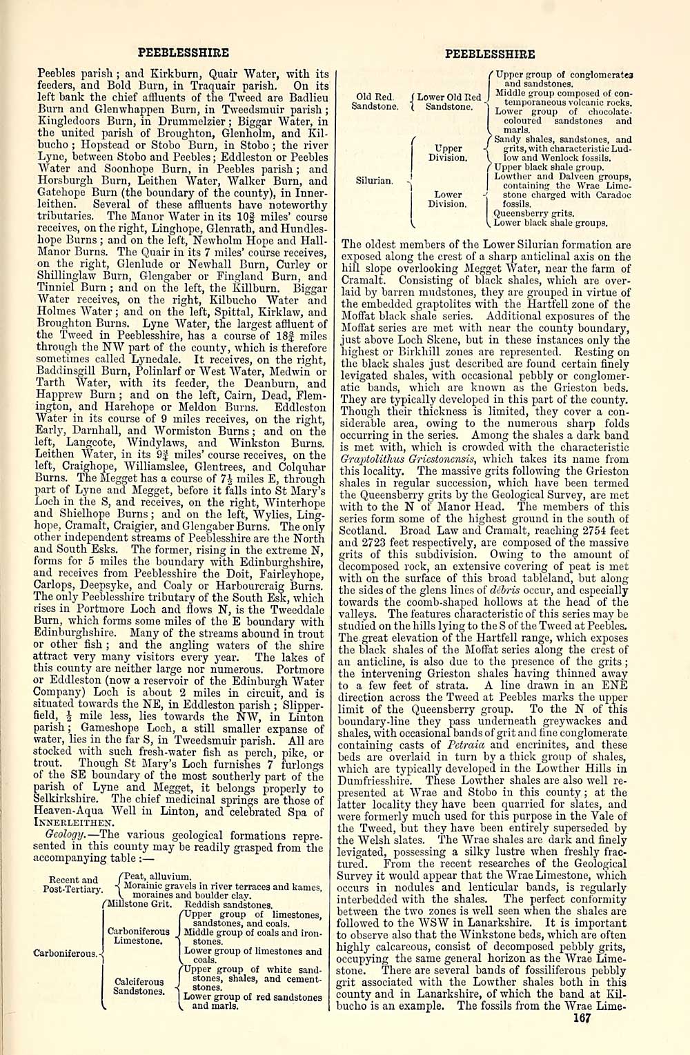
Geology. — 'The various geological formations repre-
sented in this county may be readily grasped from the
accompanying table : —
Recent and /Teat, alluvium.
Post-Tertiarv 1 *I°™"'<' gravels in river terraces and kames,
^' V moraines and boulder clay.
/"Millstone Grit. Reddish sandstones.
{Upper group of limestones,
sandstones, and coals.
Middle group of coals and iron-
stones.
Lower group of limestones and
coals.
{Upper group of white sand-
stones, shales, and cement-
stones.
Lower group of red sandstones
and marls.
PEEBLESSHIRE
Calciferous
Sandstones.
Old Red.
Sandstone.
Silurian.
[ Lower Old Red
[ Sandstone.
Upper
Division.
Lower
Division.
Upper group of conglomeratca
and sandstones.
Middle group composed of con-
temporaneous volcanic rocks.
Lower group of cliocolate-
[ coloured sandstones and
I marls.
/ Sandy shales, sandstones, and
-< grits, with characteristic Lud-
l low and Wenlock fossils.
f Upper black shale group.
Lowther and Dalveen groups,
I containing the Wrae Lime-
-; stone charged with Caradoc
fossils.
Queensberry grits,
l^ Lower black shale groups.
The oldest members of the Lower Silurian formation are
exposed along the crest of a sharp auticlinal axis on the
hill slope overlooking Megget Water, near the farm of
Cramalt. Consisting of black shales, which are over-
laid by barren mudstones, they are grouped in virtue of
the embedded graptolites with the Hartfell zone of the
Moffat black shale series. Additional exposures of the
Moffat series are met with near the county boundary,
just above Loch Skene, but in these instances only the
highest or Birkhill zones are represented. Resting on
the black shales just described are found certain finely
levigated shales, with occasional pebbly or conglomer-
atic bands, which are known as the Grieston beds.
They are typically developed in this part of the county.
Though their thickness is limited, they cover a con-
siderable area, owing to the numerous sharp folds
occurring in the series. Among the shales a dark band
is met with, which is crowded with the characteristic
GraiAolithus Gricstoncnsis, which takes its name from
this locality. The massive grits foUomng the Grieston
shales in regular succession, which have been termed
the Queensberry grits by the Geological Survey, are met
with to the N of Manor Head. 'The members of this
series form some of the highest ground in the south of
Scotland. Broad Law and Cramalt, reaching 2754 feet
and 2723 feet respectively, are composed of the massive
grits of this subdivision. Owing to the amount of
decomposed rock, an extensive covering of peat is met
with on the surface of this broad tableland, but along
the sides of the glens lines of debris occur, and especially
towards the coomb-shaped hollows at the head of the
valleys. The features characteristic of this series may be
studied on the hills lying to the S of the Tweed at Peebles.
The great elevation of the Hartfell range, which exposes
the black shales of the Moffat series along the crest of
an anticline, is also due to the presence of the grits ;
the intervening Grieston shales having thinned away
to a few feet of strata. A line drawn in an ENE
direction across the Tweed at Peebles marks the upper
limit of the Queensberry group. To the N of this
boundary-line they pass underneath greywackes and
shales, with occasional bands of grit and fine conglomerate
containing casts of Petraia and encriuites, and these
beds are overlaid in turn by a thick group of shales,
which are typically developed in the Lowther Hills in
Dumfriesshire. These Lowther shales are also well re-
presented at AA'rae and Stobo in this county ; at the
latter locality they have been quarried for slates, and
were formerly much used for this purpose in the A''ale of
the Tweed, but they have been entirely superseded by
the AVelsh slates. The AVrae shales are dark and finely
levigated, possessing a silky lustre when freshly frac-
tured. From the recent researches of the Geological
Survey it would appear that the AVrae Limestone, which
occurs in nodules and lenticular bands, is regularly
interbedded with the shales. The perfect conformity
between the two zones is well seen when the shales are
followed to the AVSAV in Lanarkshire. It is important
to observe also that the AVinkstone beds, which are often
highly calcareous, consist of decomposed pebbly grits,
occupying the same general horizon as the AVrae Lime-
stone. 'There are several bands of fossiliferous pebbly
grit associated with the Lowther shales both in this
county and in Lanarkshire, of which the band at Kil-
bucho is an example. The fossils from the AVrae Lime-
167
Peebles parish ; and Kirkburn, Quair Water, with its
feeders, and Bold Burn, in Traquair parish. On its
left bank the chief affluents of the Tweed are Badlieu
Burn and Glenwhappen Burn, in Tweedsmuir parish ;
Kingledoors Burn, in Drummelzier ; Biggar Water, in
the united parish of Broughton, Glenholm, and Kil-
bucho ; Hopstead or Stobo Burn, in Stobo ; the river
Lyno, between Stobo and Peebles ; Eddleston or Peebles
Water and Soonhope Burn, in Peebles parish ; and
Horsburgh Burn, Leithen Water, Walker Burn, and
Gatehope Burn (the boundary of the county), in Inner-
leithen. Several of these affluents have noteworthy
tributaries. The Manor Water in its 10| miles' course
receives, on the right, Linghope, Glenrath, and Hundles-
hope Burns ; and on the left, Newholm Hope and Hall-
Manor Burns. The Quair in its 7 miles' course receives,
on the right, Glenlude or Newhall Burn, Curley or
Shillinglaw Burn, Glengaber or Fingland Burn, and
Tinniel Burn ; and on the left, the Killburn. Biggar
Water receives, on the right, Kilbucho Water and
Holmes Water ; and on the left, Spittal, Kirklaw, and
Broughton Burns. Lyne AVater, the largest affluent of
the Tweed in Peeblesshire, has a course of 18f miles
through the NW part of the county, which is therefore
sometimes called Lynedale. It receives, on the right,
Baddinsgill Burn, Polinlarf or AVest Water, Medwin or
Tarth Water, with its feeder, the Deanburn, and
Happrcw Burn ; and on the left. Cairn, Dead, Flem-
ington, and Harehope or Meldon Burns. Eddleston
Water in its course of 9 miles receives, on the right.
Early, Darnhall, and Wormiston Burns ; and on the
left, Langcote, Windylaws, and Winkston Burns.
Leithen Water, in its 9 j miles' course receives, on the
left, Craighope, AVilliamslee, Glentrees, and Colquhar
Burns. The Megget has a course of 7J miles E, through
part of Lyne and Megget, before it falls into St Mary's
Loch in the S, and receives, on the right, Winterhope
and Shielhope Burns ; and on the left, Wylies, Ling-
hope, Cramalt, Craigier, and Glengaber Burns. The only
other independent streams of Peeblesshire are the North
and South Esks. The former, rising in the extreme N,
forms for 5 miles the boundary with Edinburghshire,
and receives from Peeblesshire the Doit, Fairleyhope,
Carlops, Deepsyke, and Coaly or Harbourcraig Burns.
The only Peeblesshire tributary of the South Esk, which
rises in Portmore Loch and flows N, is the Tweeddale
Burn, which forms some miles of the E boundary with
Edinburghshire. Many of the streams abound in trout
or other fish ; and the angling waters of the shire
attract very many visitors every year. The lakes of
this county are neither large nor numerous. Portmore
or Eddleston (now a reservoir of the Edinburgh AVater
Company) Loch is about 2 miles in circuit, and is
situated towards the NE, in Eddleston parish ; Slipper-
field, I mile less, lies towards the NAV, in Linton
parish; Gameshope Loch, a still smaller expanse of
water, lies in the far S, in Tweedsmuir parish. All are
stocked with such fresh-water fish as perch, pike, or
trout. Though St iilary's Loch furnishes 7 furlongs
of the SE boundary of the most southerly part of the
parish of Lyne and Megget, it belongs properly to
Selkirkshire. The chief medicinal springs are those of
Heaven-Aqua AVell in Linton, and celebrated Spa of
Innerleithen.
Geology. — 'The various geological formations repre-
sented in this county may be readily grasped from the
accompanying table : —
Recent and /Teat, alluvium.
Post-Tertiarv 1 *I°™"'<' gravels in river terraces and kames,
^' V moraines and boulder clay.
/"Millstone Grit. Reddish sandstones.
{Upper group of limestones,
sandstones, and coals.
Middle group of coals and iron-
stones.
Lower group of limestones and
coals.
{Upper group of white sand-
stones, shales, and cement-
stones.
Lower group of red sandstones
and marls.
PEEBLESSHIRE
Calciferous
Sandstones.
Old Red.
Sandstone.
Silurian.
[ Lower Old Red
[ Sandstone.
Upper
Division.
Lower
Division.
Upper group of conglomeratca
and sandstones.
Middle group composed of con-
temporaneous volcanic rocks.
Lower group of cliocolate-
[ coloured sandstones and
I marls.
/ Sandy shales, sandstones, and
-< grits, with characteristic Lud-
l low and Wenlock fossils.
f Upper black shale group.
Lowther and Dalveen groups,
I containing the Wrae Lime-
-; stone charged with Caradoc
fossils.
Queensberry grits,
l^ Lower black shale groups.
The oldest members of the Lower Silurian formation are
exposed along the crest of a sharp auticlinal axis on the
hill slope overlooking Megget Water, near the farm of
Cramalt. Consisting of black shales, which are over-
laid by barren mudstones, they are grouped in virtue of
the embedded graptolites with the Hartfell zone of the
Moffat black shale series. Additional exposures of the
Moffat series are met with near the county boundary,
just above Loch Skene, but in these instances only the
highest or Birkhill zones are represented. Resting on
the black shales just described are found certain finely
levigated shales, with occasional pebbly or conglomer-
atic bands, which are known as the Grieston beds.
They are typically developed in this part of the county.
Though their thickness is limited, they cover a con-
siderable area, owing to the numerous sharp folds
occurring in the series. Among the shales a dark band
is met with, which is crowded with the characteristic
GraiAolithus Gricstoncnsis, which takes its name from
this locality. The massive grits foUomng the Grieston
shales in regular succession, which have been termed
the Queensberry grits by the Geological Survey, are met
with to the N of Manor Head. 'The members of this
series form some of the highest ground in the south of
Scotland. Broad Law and Cramalt, reaching 2754 feet
and 2723 feet respectively, are composed of the massive
grits of this subdivision. Owing to the amount of
decomposed rock, an extensive covering of peat is met
with on the surface of this broad tableland, but along
the sides of the glens lines of debris occur, and especially
towards the coomb-shaped hollows at the head of the
valleys. The features characteristic of this series may be
studied on the hills lying to the S of the Tweed at Peebles.
The great elevation of the Hartfell range, which exposes
the black shales of the Moffat series along the crest of
an anticline, is also due to the presence of the grits ;
the intervening Grieston shales having thinned away
to a few feet of strata. A line drawn in an ENE
direction across the Tweed at Peebles marks the upper
limit of the Queensberry group. To the N of this
boundary-line they pass underneath greywackes and
shales, with occasional bands of grit and fine conglomerate
containing casts of Petraia and encriuites, and these
beds are overlaid in turn by a thick group of shales,
which are typically developed in the Lowther Hills in
Dumfriesshire. These Lowther shales are also well re-
presented at AA'rae and Stobo in this county ; at the
latter locality they have been quarried for slates, and
were formerly much used for this purpose in the A''ale of
the Tweed, but they have been entirely superseded by
the AVelsh slates. The AVrae shales are dark and finely
levigated, possessing a silky lustre when freshly frac-
tured. From the recent researches of the Geological
Survey it would appear that the AVrae Limestone, which
occurs in nodules and lenticular bands, is regularly
interbedded with the shales. The perfect conformity
between the two zones is well seen when the shales are
followed to the AVSAV in Lanarkshire. It is important
to observe also that the AVinkstone beds, which are often
highly calcareous, consist of decomposed pebbly grits,
occupying the same general horizon as the AVrae Lime-
stone. 'There are several bands of fossiliferous pebbly
grit associated with the Lowther shales both in this
county and in Lanarkshire, of which the band at Kil-
bucho is an example. The fossils from the AVrae Lime-
167
Set display mode to: Large image | Transcription
Images and transcriptions on this page, including medium image downloads, may be used under the Creative Commons Attribution 4.0 International Licence unless otherwise stated. ![]()
| Gazetteers of Scotland, 1803-1901 > Ordnance gazetteer of Scotland > Volume 5 > (257) Page 167 - PEE |
|---|
| Permanent URL | https://digital.nls.uk/97387034 |
|---|
| Attribution and copyright: |
|
|---|---|
| Description | A survey of Scottish topography, statistical, biographical, and historical. Edited by Francis H. Groome. Edinburgh: Thomas C. Jack, 1884-85. "General survey": v.6, 134 p. at end. |
|---|---|
| Shelfmark | Map.Ref.C18 |
| Additional NLS resources: | |
| Description | 20 volumes of the most popular descriptive gazetteers of Scotland, providing a comprehensive geographical encyclopaedia of Scotland in the 19th century. Principal places in Scotland, including towns, counties, castles, glens, antiquities and parishes, are listed alphabetically. Each entry includes detailed historical and geographical information about each place. |
|---|---|