Ordnance gazetteer of Scotland > Volume 3
(59) Page 581 - ETT
Download files
Complete book:
Individual page:
Thumbnail gallery: Grid view | List view

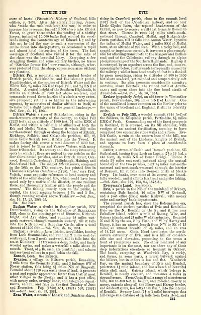
ETTRICK PEN
score of liarts ' (Pitscottie's History of Scotland, folio
edition, p. 143). After this stately hunting, James,
who ' made the rush-bush keep the cow,' in order to
increase his revenues, turned 10,000 sheep into Ettrick
Forest, to graze there under the tending of a thrifty
keeper, instead of 10,000 bucks that scoured its wood-
lands during the bounteous age of Edward I. ; and by
this act he led the way to such a conversion of the
entire forest into sheep-pasture, as occasioned a rapid
and almost total destruction of the trees. The last
sovereign of Scotland who visited it for the sake of
the chase was the beautiful Mary. Excepting a few
straggling thorns, and some solitary birches, no traces
of ' Ettricke foreste feir ' now remain, although, wher-
ever protected from the sheep, copses soon arise without
any planting.
Ettrick Pen, a moimtain on the mutual border of
Ettrick parish, Selkirkshire, and Eskdalemuir parish,
Dumfriesshire, at the sources of Ettrick Water and the
White Esk, 2J miles ENE of Capel Fell, and 7J ENE of
Moffat. A central height of the Southern Highlands, it
attains an altitude of 2269 feet above sea-level, and
commands round three-fourths of a circle a very exten-
sive prospect ; yet it is so hidden in the intervening
segment, by mountains of similar altitude to itself, as
to make but a slight figure in the general landscape. —
Ord. Sur., sh. 16, 1864.
Ettrick Water, a river of Selkii'kshire, rising in the
south-western extremity of the county, on Capel Fell
(2223 feet), at an altitude of 1900 feet, 5^ miles ENE of
Moffat, and within a half-mile of affluents of both the
Esk and Moffat Water. Thence it winds 32g miles
north-eastward through or along the borders of Ettrick,
Kirkhope, Selkirk, and Galashiels parishes, till, 2J
miles below Selkirk town, it falls into the Tweed. It
makes during this course a total descent of 1600 feet,
and is joined by Tiraa and Yarrow Waters, mth many
lesser tributaries. Its scenery and the many interesting
spots by which it flows are noticed in our articles on the
four above-named parishes, and on Ettrick Forest, Oak-
wood, Bowhill, Carterhaugh, Philiphaugh, Haining, and
Sunderland Hall. The song of Ettrick Bccnfcs, composed
in the 16th or the 17tli century, but printed first in
Thomson's Orpheus Calcdonius (1725), 'has,' says Prof.
Veitch, ' some exquisite references to local scenery and
traits of the older shepherd life, which could have been
noted only by a native of the district, or one resident
there, and thoroughly familiar with the people and the
scenes.' The fishing, mostly open to the public, is
capital, the trout ranging between J lb. and 3 lbs.,
though running smaller above Tushielaw. — Ord. Sur.,
shs. 16, 17, 25, 1864-65.
Eu. See Ewe.
Euchan Water, a rivulet in Sanquhar parish, NW
Dumfriesshire, rising on the SE slope of Blaoklaeg
Hill, close to the meeting-point of Dumfries, Kirkcud-
bright, and Ayr shires, and running 9J miles east-
north-eastward through mountain scenery, till it falls
into the Nith opposite Sanquhar Castle, after a total
descent of 1500 i<xt.—Ord. Sur., sh. 15, 1864.
Euchar, a rivulet in Lorn district, Argyllshire, issuing
from Loch Scammadale, and running 2 miles west-by-
southward, then 2 north-westward, till it falls into the
sea at Kilninver. It traverses a deep, rocky, and finely
wooded ravine, and makes a waterfall a mile above its
mouth. Trout, of J lb. each, are plentiful ; and salmon
and sea-trout collect in a pool below the fall.
Eunaoh, Loch. See Ennich.
Evanton, a village in Kiltearn parish, Ross-shire,
5 nrile from the Cromarty Firth, and 3 furlongs SW of
Novar station, this being 6\ miles NE of Dingwall.
Founded about 1810 on a waste piece of land, it presents
a neat and regular appearance, better than that of most
other villages in the North ; and it has a post office,
mth money order, savings' bank, and telegraph depart-
ments, an inn, and fairs on the first Tuesday of June
and December. Pop. (1860) 584, (1871) 526, (1881)
436.— Orrf. Sv.r., sh. 93, 1881.
Evan Water, a stream of Lanark and Dumfries shires,
EVIE
rising in Crawford parish, close to the summit level
(1012 feet) of the Caledonian railway, and so near
Little Clydes Burn, the reputed head-stream of the
Clyde, as now to receive a rill that formerly flowed to
that river. Thence it runs 12J miles south-south-
eastward through Crawford, Moffat, and Kirkpatrick-
Juxta parishes, till it faUs into Annan Water, opposite
the influx of Moffat Water, and 2 miles SSE of Jloffat
town, at an altitude of 290 feet. With a rocky bed, and
a rapid or impetuous current, it traverses a glen remark-
able for affording transit both to the Glasgow and Carlisle
road and to' the Caledonian railway through an alpine
precipitous range of the Southern Highlands. High up it
is conveyed by an aqueduct across the line, and, soon re-
appearing far below, it afterwards is frequently crossed by
the railway ; whilst from head nearly to foot it is flanked
by green mountains, rising to altitudes of 800 to 1800
feet above sea-level, yet rounded and comparatively soft
in contour. Its glen possesses considerable amenity ;
contains, above Beattock, the ruined castle of Achin-
CAss ; and opens there into the fine broad strath of
Aunandale. — Ord. Sur., sh. 16, 1864.
Evelaw (popularly Ively), an old tower in Westruther
parish, Berwickshire, lOJ miles ENE of Lauder. One
of the castellated houses common on the Border prior to
the union of Scotland and England, it still is tolerably
entire.
Eveliek or Pole Hill, a wooded summit (944 feet) of
the Sidlaws, in Kilspindie parish, Perthshire, 5.^ miles
ENE of Perth. Commanding one of the iinest prospects
in Scotland, it is croAvned, on its SE shoulder, with
vestiges of an ancient fortification, seeming to have
comprised two concentric stone walls and a fosse. Eve-
lick Castle, a ruin at the eastern base of the hill, was
the ancient seat of the Lindsays, knights of Eveliek,
and appears to have been a place of considerable
strength.
Evelix, a stream of Creich and Dornoch parishes, SE
Sutherland, issuing from Loch an Lagain (7 J x If furl. ;
446 feet), 4J miles NE of Bonar Bridge." Thence it
winds 5J miles east-south-eastward along the mutual
boundary of the two parishes, next 7i miles east-south-
eastward and west-south-westward through the interior
of Dornoch, till it falls into Dornoch Firth at Meikle
Ferry. Its banks, over most of its course, are beauti-
fully wooded ; and it affords fair trout and grilse fishing.
—Ord. Sur., shs. 102, 103, 94, 1878-81.
Everyman's Land. See Scone.
Evie, a parish in the NE of the mainland of Orkney,
containing Dale hamlet, 16 miles NW of Kirkwall,
and a post office (Evie) under Kii-kwall, with money
order and savings' bank departments.
The present parish has, since the Reformation era,
comprised the ancient parishes of Evie and Rendall —
Evie on the N, Rendall on the S ; and it lies near
Enhallow island, within a mile of Rousay, AVire, and
Gairsay islands, and 2 J miles AV of Shapinshay. Bounded
N and E by the sea, S by Firth, and W by Harray and
Birsay, it has an utmost length from NW to SE of 15
miles, an utmost breadth of 4 J miles, and an area
of 14,720 acres. Costa Head terminates the north-
eastern extremity of Evie, and is a hill of consider-
able size and elevation, presenting to the ocean a
front of precipitous rock. No other headland of any
importance is on the coast, nor are there any of those
deep indentations elsewhere so frequent in Orkney.
The beach, excepting at Woodwick Bay, is rocky,
and forms, in some parts, a mural bulwark against
the billows, but in others is low and flat. Woodwick
Bay, on the mutual boundary of Evie and KendaU,
penetrates IJ mile inland, and has a beach of beautifuj
white shell sand. Gairsay island, which belongs tc
Rendall, is nearly circular, and measures 4 miles in
circumference. From Costa Head a range of monotonous
hills, 300 to 400 feet in height, and moorish mostly or
mossy, extends along all the Birsay and Harray border,
and sends off spm's, less lofty than itself, into the interior
of Rendall. Swaney Loch (IJ x 1 mile) interrupts that
hill-range at a distance of IJ mile from Costa Head, and
581
Set display mode to: Large image | Transcription
Images and transcriptions on this page, including medium image downloads, may be used under the Creative Commons Attribution 4.0 International Licence unless otherwise stated. ![]()
| Gazetteers of Scotland, 1803-1901 > Ordnance gazetteer of Scotland > Volume 3 > (59) Page 581 - ETT |
|---|
| Permanent URL | https://digital.nls.uk/97377162 |
|---|
| Attribution and copyright: |
|
|---|---|

