Ordnance gazetteer of Scotland > Volume 3
(58) Page 580
Download files
Complete book:
Individual page:
Thumbnail gallery: Grid view | List view

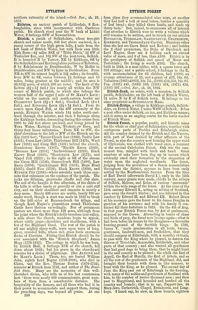
ETTLETON
northern extremity of the island. — Ord. Sur., sh. 29,
1873.
Ettleton, an ancient parish of Liddesdale, S Rox-
burghshii'e, since 1604 incorporated with Castleton
parish. Its church stood near the W bank of Liddel
Water, 9 furlongs SSW of Newcastleton.
Ettrick, a parish of Selkirkshire, whose tree-girt
church and manse nestle, 800 feet above sea-level, in a
sunny corner of the high green hills, J mile from the
left bank of Ettrick Water, but Tvith their own little
Kirk Burn— 4f miles SSE of ' Tibby Shiels,' Sf SW of
Tushielaw Inn, and 18J SW of the post-town, Selkirk.
It is bounded N by Yarrow, NE by Kirkhope, SE by
the Selkirkshire and Roxburghshire portions of Roberton,
S by Eskdalemuir in Dumfriesshire, AV by Moffat in
Dumfriesshire, and NW by Lyne in Peeblesshire. From
NE to SW its utmost length is 12| miles ; its breadth,
from NW to SE, varies between 74 furlongs and 10
miles, being greatest at the middle ; and its area is
42,682| acres, of which 296 are water. The Loch of the
Lowes (6|xlf furl.) lies nearly all within the NW
corner of Ettrick parish, to which also belongs the
western half of the upper f mOe of St Maky's Loch ;
whilst on the eastern and south-eastern border are
Cleaebukn Loch (2Jxl fuii.), Crooked Loch (2x1
furl.), and Kingside Looh (2Jxlf furl.). From its
source upon Capel Fell, at the SW extremity of the
parish, Ettrick Water winds 14^ miles north-east-
ward through the interior, and then 9 furlongs along
the Kirkhope border, descending during this course from
1900 to 745 feet above sea-level, and being joined by
TiMA Water, • Rankle Burn, Tushielaw Burn, and
thirty-four lesser tributaries. From NE to SW, the
chief elevations to the left or NW of the Ettrick are the
Kip (1293 feet), "Turner Clench Law (1809), Tushie Law
(1431), Coom Law (1619), Thirlestane Hill (1475), Ward
Law (1951) and Craig Hill (1597) behind the church,
Penniestone Knowe (1807), *Muckle Knees (1929),
*Herman Law (2014), *Andrewhinney (2220), Black
Knowe Head (1938), *Bodesbeck Law (2173), and
*Capel Fell (2223) ; to the right or SE of the stream
rise Cacra Hill (1546), Gamescleuch Hill (1490), Law
Kneis (1634), *Quickningair Hill (1601), Hope Head
(1697), Cauld Face (1756), Black Knowe (1804), and
Ettrick Pen (2269) — where asterisks mark those sum-
mits that culminate on the confines of the parish. The
rocks are Silurian, gi-eywacke chiefly and clay slate.
The soil of the haughs is iine alluvium, of the skirts of
the hOls is either sandy or gravelly or else a cold stiff
clay, and on their shoulders and summits is mostly a
deep moss. Barely 400 acres are arable, barely 300 are
under wood, though a start was made in 1865 to break
up the hill -sides at Ramsaycleuch for tillage, and
though Lord Napier's plantations round Thirlestane
Castle have thriven exceedingly. Nor of permanent
pasture are there more than 120 acres, although from
the point where the Ettrick's defile broadens into valley,
a mile above the church, meadows begin to appear,
where cattle graze — Ayrshires and shorthorns, with a
few of the Highland breed. The rest of the parish is
all one mighty sheep-walk, wave upon wave of long,
green, rounded hills, whose rich grass feeds enormous
flocks of Cheviots. Fitting that Ettrick should be for
ever associated with the ' Ettrick Shepherd, ' James
Hogg (1770-1835). The cottage in which he was born,
by Ettrick Hall, 3 fmdongs ESE of the church, fell
down about 1830 ; but his grave in the churchyard
remains for a shrine of pilgrimage. (See Altrive and
St MLaey's Loch.) There, too, are buried William
John, eighth Lord Napier (1786-1834), who died in
China, ihd the Rev. Thomas Boston (1676-1732),
minister of Ettrick from 1707, and author of The Four-
fold State. Many are the memories of this well-
cherished divine, who tells us of his last communion
how 'there, were nearly 800 commimicants, great num-
bers of them from a considerable distance. Tlie
hospitality of the farmers, and all those who had it in
their power to accommodate and support them, during
the preaching days, was beyond all praise. At one
580
ETTRICK FOREST
farm place they accommodated nine sciare, at another
they had half a boU of meal baken, besides a quantity
of loaf bread ; they killed three lambs, and made up
thirty beds.' But, indeed, to enumerate all of interest
that attaches to Ettrick were to write a volume which
still remains to be written, and to trench on our articles
BuccLEucH, Tushielaw, Gamescleuch, Chapelhope,
Kirkhope, and Thirlestane Castle. Mansions other
than the last are Cacra Bank and Rodono ; and besides
the 2 chief proprietors, the Duke of Buccleuch and
Lord Napier, there are 2 holding each an annual
value of more, and 6 of less, than £100. Ettrick is in
the presbytery of Selkirk and synod of Merse and
Teviotdale ; the living is worth £342. The church,
built in 1824, is a neat edifice, with a square tower and
310 sittings ; and a public school, 3 fmiongs to the E,
with accommodation for 62 children, had (1880) an
average attendance of 25, and a grant of £31, 14s. 6d.
Valuation (1865) £9852, 19s. 7d., (1880) £12,356, 12s. 6d.
Pop. (1801) 445, (1831) 530, (1861) 434, (1871) 434,
(1881) 397.— Ord Siir., sh. 16, 1864.
Ettrick-Bank, an estate, with a mansion, in Selkirk
parish, Selkii-kshire, on the left bank of Ettrick Water,
2J miles N by E of Selkirk town. It belongs to the
same proprietor as Sunderland Hall.
Ettrick-Bridge, a village in Kirkhope parish, Selkirk-
shire, on Ettrick Water, 7 miles WSW of Selku-k. It has
a post oflice under Selkirk, an inn, and Kirkhope manse ;
and it serves as an angling centre for the lower reaches
of Ettrick Water.
Ettrick Forest, a popular, poetic, and historic name
for the whole or chief part of Selkirkshire, together with
contiguous parts of Peebles and Edinburgh shires.
AU the country drained by the Ettrick and the Yarrow,
with part of that drained by other affluents of the
Tweed, as also the country now forming the upper ward
of Clydesdale, was clothed Tsith wood once, a remnant
of the ancient Caledonian Forest. Oak was the com-
monest tree, mingled with birch and hazel. Great
numbers of oaks have been dug up in mosses which
evidently owed their formation to the stagnation of
water upon the neglected woodlands. The forest,
judging from the prevalence of a Saxon nomenclature
throughout the district, appears to have been early
settled by the Northumbrian Saxons. From the time
of Earl David (afterwards David I.), early in the 12th
century, many grants were made, chiefly to the abbeys
of Selkirk, Melrose, and Kelso, of various ■' easements '
within the wide range of the forest. At the close of the
13th century Edward I., acting as arbiter of Scotland,
gave away the forest's timber ; and was followed in this
conduct by Edward II. and Edward III. Robert Bruce
at his accession gave the forest to Sir James Douglas in
guerdon of his services ; and with his family it con-
tinued tUl their forfeiture in 1455. On the 4th of Aug.
in that year Ettrick Forest was, by Act of parliament,
annexed to the Crown. Abounding in beasts of chase
and birds of prey, the forest now became again — what it
had been before its tenure by the Douglases — a favourite
hunting-ground of the Scottish kings. In 1528,
James V. ' made proclamation to all lords, barons,
gentlemen, landward-men, and freeholders, that they
should compear at Edinburgh, with a month's victuals,
to pass with the King where he pleased, to danton the
thieves of Tiviotdale, Annandale, Liddisdale, and other
parts of that country ; and also warned all gentlemen
that had good dogs to bring them, that he might hunt
in the said country as he pleased : the whilk the Earl of
Argyll, the Earl of Huntly, the Earl of Athole, and so
all the rest of the gentlemen of the Highland, did, and
brought their hounds with them in like manner, to
hunt with the King, as he pleased. The second day of
June the King past out of Edinburgh to the hunting,
with many of the nobles and gentlemen of Scotland with
him, to the number of twelve thousand men ; and then
past to Meggitland, and hounded and hawked all the
country and bounds ; that is to say, Pappert-law, St
Mary-laws, Carlavirick, Chapel, Ewindoores, and Long-
hope. I heard say, he slew, in these bounds, eighteen
Set display mode to: Large image | Transcription
Images and transcriptions on this page, including medium image downloads, may be used under the Creative Commons Attribution 4.0 International Licence unless otherwise stated. ![]()
| Gazetteers of Scotland, 1803-1901 > Ordnance gazetteer of Scotland > Volume 3 > (58) Page 580 |
|---|
| Permanent URL | https://digital.nls.uk/97377150 |
|---|
| Attribution and copyright: |
|
|---|---|

