Download files
Complete book:
Individual page:
Thumbnail gallery: Grid view | List view
16
ADAM AND CHARLES BLACK’S PUBLICATIONS.
BLACK’S TRAVELLING MAPS—(continued).
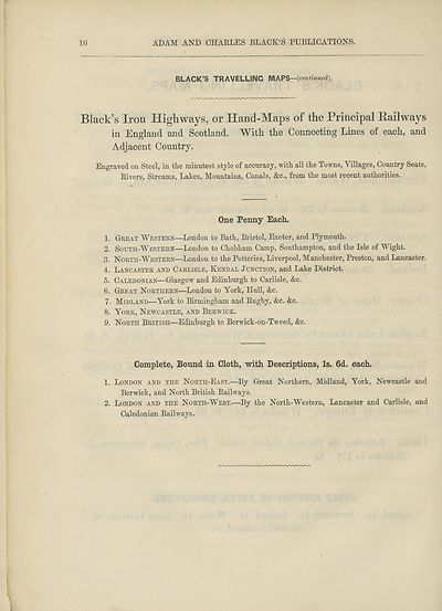
Black’s Iron Highways, or Hand-Maps of the Principal Railways
in England and Scotland. With the Connecting Lines of each, and
Adjacent Country.
Engraved on Steel, in the minutest style of accuracy, with all the Towns, Villages, Country Seats,
Rivers, Streams, Lakes, Mountains, Canals, &c., from the most recent authorities.
One Penny Each.
1. Great Western—London to Bath, Bristol, Exeter, and Plymouth.
2. South-Western—London to Chobham Camp, Southampton, and the Isle of Wight.
3. North-Western—London to the Potteries, Liverpool, Manchester, Preston, and Lancaster.
4. Lancaster and Carlisle, Kendal Junction, and Lake District.
5. Caledonian—Glasgow and Edinburgh to Carlisle, &c.
6. Great Northern—London to York, Hull, &c.
7. Midland—York to Birmingham and Rugby, &c. &c.
8. York, Newcastle, and Berwick.
9. North British—Edinburgh to Berwick-on-Tweed, &c.
Complete, Bound in Cloth, with Descriptions, Is. 6d. each.
1. London and the North-East.—By Great Northern, Midland, York, Newcastle and
Berwick, and North British Railways.
2. London and the North-West.—By the North-Western, Lancaster and Carlisle, and
Caledonian Railways.
ADAM AND CHARLES BLACK’S PUBLICATIONS.
BLACK’S TRAVELLING MAPS—(continued).
Black’s Iron Highways, or Hand-Maps of the Principal Railways
in England and Scotland. With the Connecting Lines of each, and
Adjacent Country.
Engraved on Steel, in the minutest style of accuracy, with all the Towns, Villages, Country Seats,
Rivers, Streams, Lakes, Mountains, Canals, &c., from the most recent authorities.
One Penny Each.
1. Great Western—London to Bath, Bristol, Exeter, and Plymouth.
2. South-Western—London to Chobham Camp, Southampton, and the Isle of Wight.
3. North-Western—London to the Potteries, Liverpool, Manchester, Preston, and Lancaster.
4. Lancaster and Carlisle, Kendal Junction, and Lake District.
5. Caledonian—Glasgow and Edinburgh to Carlisle, &c.
6. Great Northern—London to York, Hull, &c.
7. Midland—York to Birmingham and Rugby, &c. &c.
8. York, Newcastle, and Berwick.
9. North British—Edinburgh to Berwick-on-Tweed, &c.
Complete, Bound in Cloth, with Descriptions, Is. 6d. each.
1. London and the North-East.—By Great Northern, Midland, York, Newcastle and
Berwick, and North British Railways.
2. London and the North-West.—By the North-Western, Lancaster and Carlisle, and
Caledonian Railways.
Set display mode to:
![]() Universal Viewer |
Universal Viewer | ![]() Mirador |
Large image | Transcription
Mirador |
Large image | Transcription
Images and transcriptions on this page, including medium image downloads, may be used under the Creative Commons Attribution 4.0 International Licence unless otherwise stated. ![]()
| Encyclopaedia Britannica > Encyclopaedia Britannica > Volume 3, Anatomy-Astronomy > (1054) |
|---|
| Permanent URL | https://digital.nls.uk/193771050 |
|---|
| Attribution and copyright: |
|
|---|---|
| Shelfmark | EB.16 |
|---|---|
| Description | Ten editions of 'Encyclopaedia Britannica', issued from 1768-1903, in 231 volumes. Originally issued in 100 weekly parts (3 volumes) between 1768 and 1771 by publishers: Colin Macfarquhar and Andrew Bell (Edinburgh); editor: William Smellie: engraver: Andrew Bell. Expanded editions in the 19th century featured more volumes and contributions from leading experts in their fields. Managed and published in Edinburgh up to the 9th edition (25 volumes, from 1875-1889); the 10th edition (1902-1903) re-issued the 9th edition, with 11 supplementary volumes. |
|---|---|
| Additional NLS resources: |
|