Encyclopaedia Britannica > Volume 21, ROT-Siam
(193) Page 183
Download files
Complete book:
Individual page:
Thumbnail gallery: Grid view | List view
LOUIS
S T
183
various barracks and offices connected with the army.
The town also contains the Senegal bank (1855), a Govern¬
ment printing-office (1855), a chamber of commerce (1869),
a public library, and an agricultural society (1874). The
round beehive huts of Guet N’dar are mainly inhabited
by native fishermen. N’dar Toute consists of villas with
gardens, and is frequented as a summer watering-place.
There is a pleasant public garden in the town, and the
neighbourhood is rendered attractive by alleys of date-
palms. As there are no natural wells on the island, and
the artesian well at the north side of the town gives only
brackish water, St Louis used to be dependent on rain-
tanks and the river (and except during the rainy season
the water in the lower part of the river is salt); but in
1879 1,600,000 francs were appropriated to the construc¬
tion of a reservoir at a height of 300 feet above the sea,
71 miles from the town. The mouth of the Senegal being
closed by a bar of sand with extremely shifting entrances
for small vessels, the steamships of the great European
lines do not come up to St Louis, and passengers, in order
to meet them, are obliged to proceed by rail to Dakar, on
the other side of Cape Yerd. Ordinary vessels have often
to wait outside or inside the bar for days or weeks and
partial unloading is often necessary. It is proposed to
construct a pier opposite Guet IST’dar. The population
of St Louis was 15,980 in 1876 and 18,924 in 1883.
Though founded in 1662, the town did not receive a
municipal government till August 1872. See Senegal.
ST LOUIS, a city of the United States, chief city of
the State of Missouri, is situated on the west bank of the
Mississippi river, 20 miles below its confluence with the
Missouri river and 200 miles above the influx of the Ohio,
in 38° 38' 3"-6 N. lat. and 90° 12' 17" W. long. It is
distant by river about 1200 miles from New Orleans, and
729 from St Paul at the head of navigation on the Missis¬
sippi, and occupies a position near the centre of the great
basin through which the mingled flood of the Mississippi
and Missouri and their extensive system of tributaries is
carried to the Gulf of Mexico. The site embraces a series of
undulations extending westwards with a general direction
nearly parallel to the river, which at this point makes a
wide curve to the east. The extreme length in a straight
line is 17 miles, the greatest width 6-60 miles, the length
of river front 19T5 miles, and the area (including con¬
siderable territory at present suburban in character) 62J
square miles. The elevation of the city directrix above
the waters of the Gulf of Mexico is 428 feet, that of the
highest point of ground in the city above the directrix is
203 feet; the extreme high-water mark above the directrix
is 7 feet 7 inches, and the extreme low-water mark below
the same is 33 feet 9f inches. The elevated site of the
city prevents any serious interruption of business by high
water, even in seasons of unusual floods.
The plan of the city is rectilinear, the ground being laid
out in blocks about 300 feet square, with the general direc¬
tion of street lines north-south and east-west. The wharf
or river front is known as the Levee or Front Street, the
next street west is Main Street, and the next Second, and
thence the streets going north-south are, with few excep¬
tions, in numerical order (Third, Fourth, &c.). Fifth Street
has recently been named Broadway. The east-west streets
bear regular names (Chestnut, Pine, Washington, Franklin,
and the like). Market Street is regarded as the middle of
the city, and the numbering on the intersecting streets
commences at that line, north and south respectively. One
hundred house numbers are allotted to each block, and
the blocks follow in numerical order. The total length of
paved streets in St Louis is 316 miles, of unpaved streets
and roads 427, total 743 miles. In the central streets,
subject to heavy traffic, the pavement is of granite blocks ;
wood, asphalt, and limestone blocks and Telford pave¬
ments are also used. There are nearly 300 miles of mac-
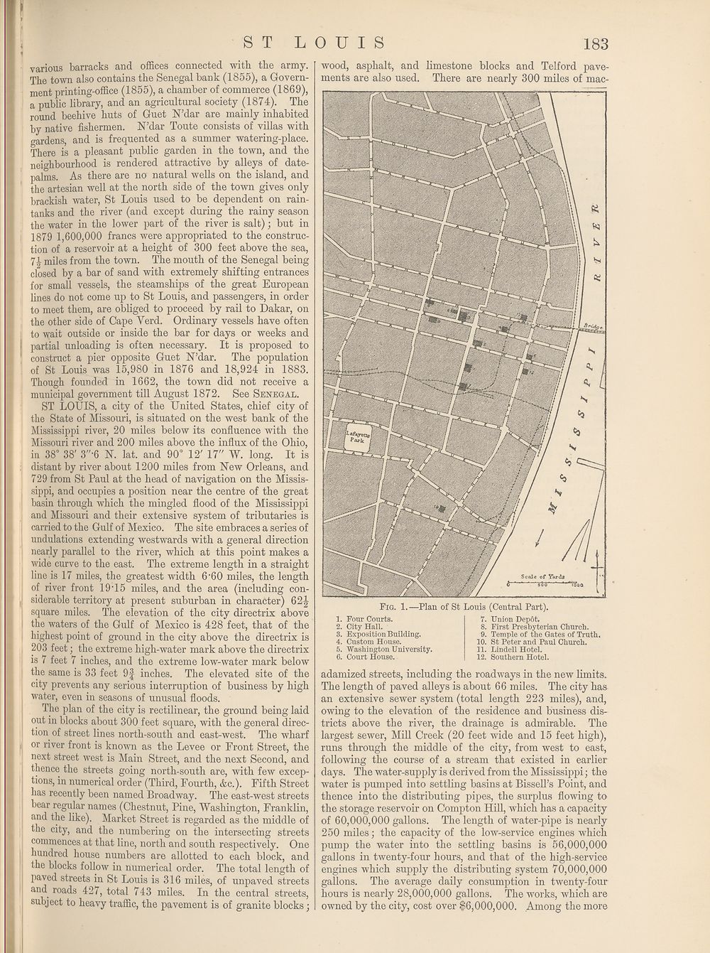
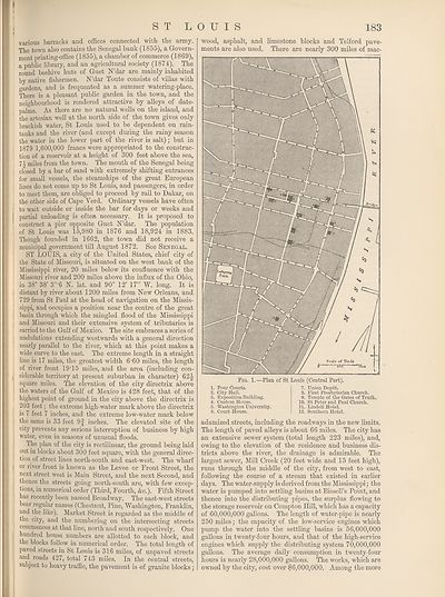
Fig. 1.—Plan of St
1. Four Courts.
2. City Hall.
3. Exposition Building.
4. Custom House.
5. Washington University.
6. Court House.
Louis (Central Part).
7. Union Dep6t.
8. First Presbyterian Church.
9. Temple of the Gates of Truth.
10. St Peter and Paul Church.
11. Lindell Hotel.
12. Southern Hotel.
adamized streets, including the roadways in the new limits.
The length of paved alleys is about 66 miles. The city has
an extensive sewer system (total length 223 miles), and,
owing to the elevation of the residence and business dis¬
tricts above the river, the drainage is admirable. The
largest sewer, Mill Creek (20 feet wide and 15 feet high),
runs through the middle of the city, from west to east,
following the course of a stream that existed in earlier
days. The water-supply is derived from the Mississippi; the
water is pumped into settling basins at Bissell’s Point, and
thence into the distributing pipes, the surplus flowing to
the storage reservoir on Compton Hill, which has a capacity
of 60,000,000 gallons. The length of water-pipe is nearly
250 miles; the capacity of the low-service engines which
pump the water into the settling basins is 56,000,000
gallons in twenty-four hours, and that of the high-service
engines which supply the distributing system 70,000,000
gallons. The average daily consumption in twenty-four
hours is nearly 28,000,000 gallons. The works, which are
owned by the city, cost over $6,000,000. Among the more
S T
183
various barracks and offices connected with the army.
The town also contains the Senegal bank (1855), a Govern¬
ment printing-office (1855), a chamber of commerce (1869),
a public library, and an agricultural society (1874). The
round beehive huts of Guet N’dar are mainly inhabited
by native fishermen. N’dar Toute consists of villas with
gardens, and is frequented as a summer watering-place.
There is a pleasant public garden in the town, and the
neighbourhood is rendered attractive by alleys of date-
palms. As there are no natural wells on the island, and
the artesian well at the north side of the town gives only
brackish water, St Louis used to be dependent on rain-
tanks and the river (and except during the rainy season
the water in the lower part of the river is salt); but in
1879 1,600,000 francs were appropriated to the construc¬
tion of a reservoir at a height of 300 feet above the sea,
71 miles from the town. The mouth of the Senegal being
closed by a bar of sand with extremely shifting entrances
for small vessels, the steamships of the great European
lines do not come up to St Louis, and passengers, in order
to meet them, are obliged to proceed by rail to Dakar, on
the other side of Cape Yerd. Ordinary vessels have often
to wait outside or inside the bar for days or weeks and
partial unloading is often necessary. It is proposed to
construct a pier opposite Guet IST’dar. The population
of St Louis was 15,980 in 1876 and 18,924 in 1883.
Though founded in 1662, the town did not receive a
municipal government till August 1872. See Senegal.
ST LOUIS, a city of the United States, chief city of
the State of Missouri, is situated on the west bank of the
Mississippi river, 20 miles below its confluence with the
Missouri river and 200 miles above the influx of the Ohio,
in 38° 38' 3"-6 N. lat. and 90° 12' 17" W. long. It is
distant by river about 1200 miles from New Orleans, and
729 from St Paul at the head of navigation on the Missis¬
sippi, and occupies a position near the centre of the great
basin through which the mingled flood of the Mississippi
and Missouri and their extensive system of tributaries is
carried to the Gulf of Mexico. The site embraces a series of
undulations extending westwards with a general direction
nearly parallel to the river, which at this point makes a
wide curve to the east. The extreme length in a straight
line is 17 miles, the greatest width 6-60 miles, the length
of river front 19T5 miles, and the area (including con¬
siderable territory at present suburban in character) 62J
square miles. The elevation of the city directrix above
the waters of the Gulf of Mexico is 428 feet, that of the
highest point of ground in the city above the directrix is
203 feet; the extreme high-water mark above the directrix
is 7 feet 7 inches, and the extreme low-water mark below
the same is 33 feet 9f inches. The elevated site of the
city prevents any serious interruption of business by high
water, even in seasons of unusual floods.
The plan of the city is rectilinear, the ground being laid
out in blocks about 300 feet square, with the general direc¬
tion of street lines north-south and east-west. The wharf
or river front is known as the Levee or Front Street, the
next street west is Main Street, and the next Second, and
thence the streets going north-south are, with few excep¬
tions, in numerical order (Third, Fourth, &c.). Fifth Street
has recently been named Broadway. The east-west streets
bear regular names (Chestnut, Pine, Washington, Franklin,
and the like). Market Street is regarded as the middle of
the city, and the numbering on the intersecting streets
commences at that line, north and south respectively. One
hundred house numbers are allotted to each block, and
the blocks follow in numerical order. The total length of
paved streets in St Louis is 316 miles, of unpaved streets
and roads 427, total 743 miles. In the central streets,
subject to heavy traffic, the pavement is of granite blocks ;
wood, asphalt, and limestone blocks and Telford pave¬
ments are also used. There are nearly 300 miles of mac-
Fig. 1.—Plan of St
1. Four Courts.
2. City Hall.
3. Exposition Building.
4. Custom House.
5. Washington University.
6. Court House.
Louis (Central Part).
7. Union Dep6t.
8. First Presbyterian Church.
9. Temple of the Gates of Truth.
10. St Peter and Paul Church.
11. Lindell Hotel.
12. Southern Hotel.
adamized streets, including the roadways in the new limits.
The length of paved alleys is about 66 miles. The city has
an extensive sewer system (total length 223 miles), and,
owing to the elevation of the residence and business dis¬
tricts above the river, the drainage is admirable. The
largest sewer, Mill Creek (20 feet wide and 15 feet high),
runs through the middle of the city, from west to east,
following the course of a stream that existed in earlier
days. The water-supply is derived from the Mississippi; the
water is pumped into settling basins at Bissell’s Point, and
thence into the distributing pipes, the surplus flowing to
the storage reservoir on Compton Hill, which has a capacity
of 60,000,000 gallons. The length of water-pipe is nearly
250 miles; the capacity of the low-service engines which
pump the water into the settling basins is 56,000,000
gallons in twenty-four hours, and that of the high-service
engines which supply the distributing system 70,000,000
gallons. The average daily consumption in twenty-four
hours is nearly 28,000,000 gallons. The works, which are
owned by the city, cost over $6,000,000. Among the more
Set display mode to:
![]() Universal Viewer |
Universal Viewer | ![]() Mirador |
Large image | Transcription
Mirador |
Large image | Transcription
Images and transcriptions on this page, including medium image downloads, may be used under the Creative Commons Attribution 4.0 International Licence unless otherwise stated. ![]()
| Encyclopaedia Britannica > Encyclopaedia Britannica > Volume 21, ROT-Siam > (193) Page 183 |
|---|
| Permanent URL | https://digital.nls.uk/193629788 |
|---|
| Attribution and copyright: |
|
|---|---|
| Shelfmark | EB.17 |
|---|---|
| Description | Ten editions of 'Encyclopaedia Britannica', issued from 1768-1903, in 231 volumes. Originally issued in 100 weekly parts (3 volumes) between 1768 and 1771 by publishers: Colin Macfarquhar and Andrew Bell (Edinburgh); editor: William Smellie: engraver: Andrew Bell. Expanded editions in the 19th century featured more volumes and contributions from leading experts in their fields. Managed and published in Edinburgh up to the 9th edition (25 volumes, from 1875-1889); the 10th edition (1902-1903) re-issued the 9th edition, with 11 supplementary volumes. |
|---|---|
| Additional NLS resources: |
|