Encyclopaedia Britannica > Volume 21, ROT-Siam
(192) Page 182 - SAI
Download files
Complete book:
Individual page:
Thumbnail gallery: Grid view | List view
182 S A I-
About 260 miles below Quebec, between Pointe des Monts
on the north and Cape Chat on the south, the St Lawrence
has a width of 30 miles, and, as this expanse is doubled
30 miles farther seaward, Cape Chat has been considered
by many geographers as the southern extremity of an
imaginary line of demarcation between the St Lawrence
river and the gulf of the same name. It may, however,
be assumed, with more propriety perhaps, taking the con¬
figuration of the gulf into special account, that Cape
Gaspe, about 400 miles below Quebec and 430 miles from
the Atlantic at the east end of the Straits of Belle Isle,
is the true mouth of the St Lawrence river.
It has been calculated by Darby, the American hydro-
grapher, that the mean discharge from the St Lawrence
river and gulf, from an area rather largely estimated at
565,000 square miles, must be upwards of 1,000,000 cubic
feet per second, taking into account the mean discharge at
Niagara, which is 389,000 cubic feet per second from a
drainage area of 237,000 square miles, and bearing in mind
the well-ascertained fact that the tributaries of the lower
St Lawrence, coming from mountainous woody regions
where snow falls from 4 to 8 feet in depth, deliver more
water per square mile than its upper tributaries.
The great prosperity and growth of Canada are owing
no doubt to its unrivalled system of intercommunication
by canal and river with the vast territories through
which the St Lawrence finds its way from the far-off
regions of the Minnesota to the seaboard. This great
auxiliary of the railways (by means of which trade is now
carried on at all seasons) must therefore be prominently
taken into account in considering the transport routes of
the future, their chief use being, as far as the conveyance
of traffic over long distances is concerned, to augment, in
the shape of feeders, the trade of the river, as long as it
keeps open, and when it closes to continue the circulation
of commerce by sledges until the ice breaks up and restores
the river to its former activity. By the published statistics
of the harbour commissioners of Montreal it appears that
during the ten years 1870-79 the opening of the navigation
at Montreal varied between 30th March and 1st May, and
the close of the navigation between 26th November and
2d January, and that, whilst the first arrival from sea
varied from 20th April to 11th May, the last departure
to sea only varied from 21st November to 29th November
during the ten years. (c. A. H.)
According to the chief geographer of the United States Geological
Survey, the following were the principal data for the St Lawrence
lakes in 1886. Area of basin of St Lawrence 457,000 square miles,
of which 330,000 belong to Canada and 127,000 to the United
States. Lake Superior—area 31,200 square miles, length 412 miles,
maximum breadth 167 miles, maximum depth 1008 feet, altitude
above sea-level 602 feet. Lake Huron—area 21,000 square miles,
263 miles long, 101 broad, maximum depth 702 feet, altitude 581
feet. Lake Michigan—area 22,450 square miles, maximum breadth
84 miles, length 345 miles, maximum depth 870 feet, altitude 581
feet. Lake St Clair—29 miles long. Lake Erie—area 9960 square
miles, length 250 miles, maximum breadth 60 miles, maximum
depth 210 feet, height above sea-level 573 feet and above Lake
Ontario 326 feet. Lake Ontario—area 7240 square miles, length
190 miles, breadth 54 miles, maximum depth 738 feet, elevation
247 feet. In 1885 the enrolled vessels on the St Lawrence lakes
belonging to the United States numbered 2497 (steam 1175, sailing
1322) with an aggregate burthen of 648,988 tons (steam 335,859 tons,
sailing 313,129 tons).
ST LEONARDS is the name given to the western and
more modern part of Hastings (q.v.), a watering-place on
the coast of Sussex, England. St Leonards proper, which
formed only a small part of the district now included
under that name, was at one time a separate township.
The population of St Leonards in 1881 was 7165.
ST LEONARDS, Edward Burtenshaw Sugden, Lord
(1781-1875), lord chancellor of England, was the son of a
hairdresser in Duke Street, Westminster, and was born in
-S A I
February 1781. After practising for some years as a con¬
veyancer, he was called to the bar at Lincoln’s Inn in 1807
having already published his well-known treatise on the
Law of Vendors and Purchasers. In 1822 he was made
king’s counsel and chosen a bencher of Lincoln’s Inn.
He was returned at different times for various boroughs
to the House of Commons, where he made himself pro¬
minent by his opposition to the Reform Bill of 1832.
He was appointed solicitor-general in 1829, was named
lord chancellor of Ireland in 1834, and again filled the
same office from 1841 to 1846. Under Lord Derby’s first
administration in 1852 he became lord chancellor and was
raised to the peerage as Lord St Leonards. In this posi¬
tion he devoted himself with energy and vigour to the
reform of the law; Lord Derby on his return to power in
1858 again offered him the same office, which from con¬
siderations of health he declined. He continued, however,
to take an active interest especially in the legal matters
that came before the House of Lords, and bestowed his
particular attention on the reform of the law of property.
He died at Boyle Farm, Thames Ditton, 29th January 1875.
Lord St Leonards was the author of various important legal
publications, many of which have passed through several editions.
Besides the treatise on purchasers already mentioned, they include
Towers, Cases decided by the House of Lords, Gilbert on Uses, New
Real Property Laws, and Handybook of Property Law.
ST LO, a town of France, chef-lieu of the department
of Manche, on the right bank of the Yire, 195 miles west
by north of Paris by the railway which here breaks up
into two branches for Coutances and Yire respectively.
The old town stands on a rocky hill (110 feet high) com¬
manding the river; the modern town spreads out below.
Notre Dame is a Gothic building of the 14th century,
with portal and two towers of the 15th. In the town-
house is the Torigny marble, commemorating the assem¬
blies held in Gaul under the Romans and now serving as
a pedestal for the bust of Leverrier the astronomer, who
was born at St L6. The museum has some good pictures,
and in the abbey of St Croix there are windows of the
14th century. The Champs de Mars is a fine tree-planted
place. Horse-breeding, cloth and calico weaving, wool¬
spinning, currying and tanning, are the local industries.
The population in 1881 was 9889 (10,121 in the commune).
St L6, founded in the Gallo-Roman period, was originally called
Briovira (bridge on the Yire), and afterwards St Etienne, the present
name being from one of its bishops (Lo, Laudus), who lived in the
6th century. By the time of Charlemagne the town was already
surrounded with wTalls and contained the abbey, which was sacked
by the Normans. In 1141 it fell into the hands of Geoffrey Planta-
genet. But in 1203 the castle opened its gates to Philip Augustus,
and, weaving being introduced, St Lo soon became a flourishing
industrial centre. In the middle of the 14th century Edward III.
of England captured the town and according to Froissart obtained
immense booty. It was again taken by the English in 1417, hut
the victory of Formigny (1450) restored it permanently to France.
The hearty welcome it gave to the Reformation brought upon St
Lo new disasters and new sieges. The revocation of the Edict of
Nantes led to the emigration of a part of the inhabitants. In 1800
the town was made the centre of the department, but by Napoleon’s
orders it was deprived of its fortifications.
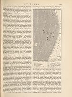
ST LOUIS, the capital of Senegambia or Senegal,
West Africa, and known to the natives as far as Timbuktu
as N’dar, is built on an island 10 sea-miles above the
mouth of the Senegal river, near the right bank, which
is there a narrow strip of sand—the Langue de Barbarie—
occupied by the villages of N’dar Toute and Guet N’dar.
Two bridges on piles connect the town with the villages;
and the Pont Faidherbe, 2132 feet long and constructed
in 1863, affords communication with Bouetville, a suburb
and the terminus of the railway, on the left bank. The
houses of the European portion of St Louis have for the
most part flat roofs, balconies, and terraces. Besides the
governor’s residence the most prominent buildings are the
cathedral, the great mosque, the court-house, and the
About 260 miles below Quebec, between Pointe des Monts
on the north and Cape Chat on the south, the St Lawrence
has a width of 30 miles, and, as this expanse is doubled
30 miles farther seaward, Cape Chat has been considered
by many geographers as the southern extremity of an
imaginary line of demarcation between the St Lawrence
river and the gulf of the same name. It may, however,
be assumed, with more propriety perhaps, taking the con¬
figuration of the gulf into special account, that Cape
Gaspe, about 400 miles below Quebec and 430 miles from
the Atlantic at the east end of the Straits of Belle Isle,
is the true mouth of the St Lawrence river.
It has been calculated by Darby, the American hydro-
grapher, that the mean discharge from the St Lawrence
river and gulf, from an area rather largely estimated at
565,000 square miles, must be upwards of 1,000,000 cubic
feet per second, taking into account the mean discharge at
Niagara, which is 389,000 cubic feet per second from a
drainage area of 237,000 square miles, and bearing in mind
the well-ascertained fact that the tributaries of the lower
St Lawrence, coming from mountainous woody regions
where snow falls from 4 to 8 feet in depth, deliver more
water per square mile than its upper tributaries.
The great prosperity and growth of Canada are owing
no doubt to its unrivalled system of intercommunication
by canal and river with the vast territories through
which the St Lawrence finds its way from the far-off
regions of the Minnesota to the seaboard. This great
auxiliary of the railways (by means of which trade is now
carried on at all seasons) must therefore be prominently
taken into account in considering the transport routes of
the future, their chief use being, as far as the conveyance
of traffic over long distances is concerned, to augment, in
the shape of feeders, the trade of the river, as long as it
keeps open, and when it closes to continue the circulation
of commerce by sledges until the ice breaks up and restores
the river to its former activity. By the published statistics
of the harbour commissioners of Montreal it appears that
during the ten years 1870-79 the opening of the navigation
at Montreal varied between 30th March and 1st May, and
the close of the navigation between 26th November and
2d January, and that, whilst the first arrival from sea
varied from 20th April to 11th May, the last departure
to sea only varied from 21st November to 29th November
during the ten years. (c. A. H.)
According to the chief geographer of the United States Geological
Survey, the following were the principal data for the St Lawrence
lakes in 1886. Area of basin of St Lawrence 457,000 square miles,
of which 330,000 belong to Canada and 127,000 to the United
States. Lake Superior—area 31,200 square miles, length 412 miles,
maximum breadth 167 miles, maximum depth 1008 feet, altitude
above sea-level 602 feet. Lake Huron—area 21,000 square miles,
263 miles long, 101 broad, maximum depth 702 feet, altitude 581
feet. Lake Michigan—area 22,450 square miles, maximum breadth
84 miles, length 345 miles, maximum depth 870 feet, altitude 581
feet. Lake St Clair—29 miles long. Lake Erie—area 9960 square
miles, length 250 miles, maximum breadth 60 miles, maximum
depth 210 feet, height above sea-level 573 feet and above Lake
Ontario 326 feet. Lake Ontario—area 7240 square miles, length
190 miles, breadth 54 miles, maximum depth 738 feet, elevation
247 feet. In 1885 the enrolled vessels on the St Lawrence lakes
belonging to the United States numbered 2497 (steam 1175, sailing
1322) with an aggregate burthen of 648,988 tons (steam 335,859 tons,
sailing 313,129 tons).
ST LEONARDS is the name given to the western and
more modern part of Hastings (q.v.), a watering-place on
the coast of Sussex, England. St Leonards proper, which
formed only a small part of the district now included
under that name, was at one time a separate township.
The population of St Leonards in 1881 was 7165.
ST LEONARDS, Edward Burtenshaw Sugden, Lord
(1781-1875), lord chancellor of England, was the son of a
hairdresser in Duke Street, Westminster, and was born in
-S A I
February 1781. After practising for some years as a con¬
veyancer, he was called to the bar at Lincoln’s Inn in 1807
having already published his well-known treatise on the
Law of Vendors and Purchasers. In 1822 he was made
king’s counsel and chosen a bencher of Lincoln’s Inn.
He was returned at different times for various boroughs
to the House of Commons, where he made himself pro¬
minent by his opposition to the Reform Bill of 1832.
He was appointed solicitor-general in 1829, was named
lord chancellor of Ireland in 1834, and again filled the
same office from 1841 to 1846. Under Lord Derby’s first
administration in 1852 he became lord chancellor and was
raised to the peerage as Lord St Leonards. In this posi¬
tion he devoted himself with energy and vigour to the
reform of the law; Lord Derby on his return to power in
1858 again offered him the same office, which from con¬
siderations of health he declined. He continued, however,
to take an active interest especially in the legal matters
that came before the House of Lords, and bestowed his
particular attention on the reform of the law of property.
He died at Boyle Farm, Thames Ditton, 29th January 1875.
Lord St Leonards was the author of various important legal
publications, many of which have passed through several editions.
Besides the treatise on purchasers already mentioned, they include
Towers, Cases decided by the House of Lords, Gilbert on Uses, New
Real Property Laws, and Handybook of Property Law.
ST LO, a town of France, chef-lieu of the department
of Manche, on the right bank of the Yire, 195 miles west
by north of Paris by the railway which here breaks up
into two branches for Coutances and Yire respectively.
The old town stands on a rocky hill (110 feet high) com¬
manding the river; the modern town spreads out below.
Notre Dame is a Gothic building of the 14th century,
with portal and two towers of the 15th. In the town-
house is the Torigny marble, commemorating the assem¬
blies held in Gaul under the Romans and now serving as
a pedestal for the bust of Leverrier the astronomer, who
was born at St L6. The museum has some good pictures,
and in the abbey of St Croix there are windows of the
14th century. The Champs de Mars is a fine tree-planted
place. Horse-breeding, cloth and calico weaving, wool¬
spinning, currying and tanning, are the local industries.
The population in 1881 was 9889 (10,121 in the commune).
St L6, founded in the Gallo-Roman period, was originally called
Briovira (bridge on the Yire), and afterwards St Etienne, the present
name being from one of its bishops (Lo, Laudus), who lived in the
6th century. By the time of Charlemagne the town was already
surrounded with wTalls and contained the abbey, which was sacked
by the Normans. In 1141 it fell into the hands of Geoffrey Planta-
genet. But in 1203 the castle opened its gates to Philip Augustus,
and, weaving being introduced, St Lo soon became a flourishing
industrial centre. In the middle of the 14th century Edward III.
of England captured the town and according to Froissart obtained
immense booty. It was again taken by the English in 1417, hut
the victory of Formigny (1450) restored it permanently to France.
The hearty welcome it gave to the Reformation brought upon St
Lo new disasters and new sieges. The revocation of the Edict of
Nantes led to the emigration of a part of the inhabitants. In 1800
the town was made the centre of the department, but by Napoleon’s
orders it was deprived of its fortifications.
ST LOUIS, the capital of Senegambia or Senegal,
West Africa, and known to the natives as far as Timbuktu
as N’dar, is built on an island 10 sea-miles above the
mouth of the Senegal river, near the right bank, which
is there a narrow strip of sand—the Langue de Barbarie—
occupied by the villages of N’dar Toute and Guet N’dar.
Two bridges on piles connect the town with the villages;
and the Pont Faidherbe, 2132 feet long and constructed
in 1863, affords communication with Bouetville, a suburb
and the terminus of the railway, on the left bank. The
houses of the European portion of St Louis have for the
most part flat roofs, balconies, and terraces. Besides the
governor’s residence the most prominent buildings are the
cathedral, the great mosque, the court-house, and the
Set display mode to:
![]() Universal Viewer |
Universal Viewer | ![]() Mirador |
Large image | Transcription
Mirador |
Large image | Transcription
Images and transcriptions on this page, including medium image downloads, may be used under the Creative Commons Attribution 4.0 International Licence unless otherwise stated. ![]()
| Encyclopaedia Britannica > Encyclopaedia Britannica > Volume 21, ROT-Siam > (192) Page 182 - SAI |
|---|
| Permanent URL | https://digital.nls.uk/193629775 |
|---|
| Attribution and copyright: |
|
|---|---|
| Shelfmark | EB.17 |
|---|---|
| Description | Ten editions of 'Encyclopaedia Britannica', issued from 1768-1903, in 231 volumes. Originally issued in 100 weekly parts (3 volumes) between 1768 and 1771 by publishers: Colin Macfarquhar and Andrew Bell (Edinburgh); editor: William Smellie: engraver: Andrew Bell. Expanded editions in the 19th century featured more volumes and contributions from leading experts in their fields. Managed and published in Edinburgh up to the 9th edition (25 volumes, from 1875-1889); the 10th edition (1902-1903) re-issued the 9th edition, with 11 supplementary volumes. |
|---|---|
| Additional NLS resources: |
|