
Download files
Complete book:
Individual page:
Thumbnail gallery: Grid view | List view
6l(> O. MILNE HOME ON THE PARALLEL ROADS OF LOCHABEK.
exceeding that level, occupying not only the Great Glen, but also the entire
district of Unachan towards Fort William,
6. Having in the foregoing leniarks explained my reasons for thinking that
the whole of this part of the Highlands was covered by drift, the next point to
which I would advert is the facility with which this detrital matter can be and
has been removed by natural streams and rivers.
As an example, I may refer to a deep gulley near the Old Catholic Burying
C! round near Achleuereuch in Glen Spean, called Cillochrill. It is situated
on a tlat bit of ground, part of the old lake bottom when the water stood at
the lowest shelf. This ground consists of an immense mass of gravel, which
presents, towards the turnpike road, steep banks of from 800 to 350 feet in
height. My guide, Angus jM'Mastek, had been resident in the Glen since
boyhood, and he pointed out to me the gully above referred to, which he stated
had been formed within hi.s own recollection, lie said that it had originated
from the plough having formed a "fan- " on the flat land too near the edge of
the bank. The rain scooped out a channel through the detritus and formed
the gully. The banks of the gully are from 40 to .30 feet high, and the width
in some places about 80 yards.
In Glen Roy there are numerous examples of burns having formed deep
gashes through the original beds of clay, which had formed the bottoms of the
old lakes. At the road on the east side of Buhuntino, which descends to Cran-
achan Bridge, there are vertical cliffs of clay, full of pebbles and boulders, 240
feet high, due to the erosion and undermining of the river Roy. It has even
cut for itself a passage through the rocks lying beneath the boulder clay, in
some places 60 to 80 feet in depth. This stream has enormous power.
Any one who walks along the banks of the River Spean from Spean Bridge
to its mouth in Loch Lochy, will not fail to be struck by the height of the
detrital clifls lining its course.
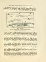
The liver channel is in some places at least 300 feet below the adjoining
general suiface, and there are terraces corresponding with the successive
subsidences. The diagram, shown in fig. 13, is a view taken from the left
bank of the River about a mile below Spean Bridge. The old Haugh-land
next the river is al)out 35 feet above it, bounded by a detrital cliff about 20
feet high. Above this cliff there is a second haugh about 60 feet above the
river, which is bounded by another detrital cliff about 20 feet high. As tliese
banks and haughs slope with the river, there can be no doubt that it produced
them. Even still, the old banks are so distinct as to show that the river Spean
here ran along a channel more than 100 feet above its pi'esent level ; so that
the ([uantit) of drift I'emoved l)y it has been enoinious.*
* .Sincif this passa^'c^ wiis wiitlcii, I Ijavc i\'^:uu oxaiiiiiuMl the Siicaii, Tlie hanks and dill's rcfi-rrcil
to in tli(; text, uiv situati'il on the east side of tliu river, ahout liall' a iiiih' liclow Kilnionivaij,' chinvli.
exceeding that level, occupying not only the Great Glen, but also the entire
district of Unachan towards Fort William,
6. Having in the foregoing leniarks explained my reasons for thinking that
the whole of this part of the Highlands was covered by drift, the next point to
which I would advert is the facility with which this detrital matter can be and
has been removed by natural streams and rivers.
As an example, I may refer to a deep gulley near the Old Catholic Burying
C! round near Achleuereuch in Glen Spean, called Cillochrill. It is situated
on a tlat bit of ground, part of the old lake bottom when the water stood at
the lowest shelf. This ground consists of an immense mass of gravel, which
presents, towards the turnpike road, steep banks of from 800 to 350 feet in
height. My guide, Angus jM'Mastek, had been resident in the Glen since
boyhood, and he pointed out to me the gully above referred to, which he stated
had been formed within hi.s own recollection, lie said that it had originated
from the plough having formed a "fan- " on the flat land too near the edge of
the bank. The rain scooped out a channel through the detritus and formed
the gully. The banks of the gully are from 40 to .30 feet high, and the width
in some places about 80 yards.
In Glen Roy there are numerous examples of burns having formed deep
gashes through the original beds of clay, which had formed the bottoms of the
old lakes. At the road on the east side of Buhuntino, which descends to Cran-
achan Bridge, there are vertical cliffs of clay, full of pebbles and boulders, 240
feet high, due to the erosion and undermining of the river Roy. It has even
cut for itself a passage through the rocks lying beneath the boulder clay, in
some places 60 to 80 feet in depth. This stream has enormous power.
Any one who walks along the banks of the River Spean from Spean Bridge
to its mouth in Loch Lochy, will not fail to be struck by the height of the
detrital clifls lining its course.
The liver channel is in some places at least 300 feet below the adjoining
general suiface, and there are terraces corresponding with the successive
subsidences. The diagram, shown in fig. 13, is a view taken from the left
bank of the River about a mile below Spean Bridge. The old Haugh-land
next the river is al)out 35 feet above it, bounded by a detrital cliff about 20
feet high. Above this cliff there is a second haugh about 60 feet above the
river, which is bounded by another detrital cliff about 20 feet high. As tliese
banks and haughs slope with the river, there can be no doubt that it produced
them. Even still, the old banks are so distinct as to show that the river Spean
here ran along a channel more than 100 feet above its pi'esent level ; so that
the ([uantit) of drift I'emoved l)y it has been enoinious.*
* .Sincif this passa^'c^ wiis wiitlcii, I Ijavc i\'^:uu oxaiiiiiuMl the Siicaii, Tlie hanks and dill's rcfi-rrcil
to in tli(; text, uiv situati'il on the east side of tliu river, ahout liall' a iiiih' liclow Kilnionivaij,' chinvli.
Set display mode to: Large image | Transcription
Images and transcriptions on this page, including medium image downloads, may be used under the Creative Commons Attribution 4.0 International Licence unless otherwise stated. ![]()
| Early Gaelic Book Collections > J. F. Campbell Collection > On the parallel roads of Lochaber > (40) |
|---|
| Permanent URL | https://digital.nls.uk/80970490 |
|---|
| Description | By David Milne Home. From the Transactions of the Royal Society of Edinburgh, vol. XXVIII. |
|---|---|
| Shelfmark | Cam.1.a.1(1) |
| Additional NLS resources: | |
| Attribution and copyright: |
|
| Description | Volumes from a collection of 610 books rich in Highland folklore, Ossianic literature and other Celtic subjects. Many of the books annotated by John Francis Campbell of Islay, who assembled the collection. |
|---|
| Description | Selected items from five 'Special and Named Printed Collections'. Includes books in Gaelic and other Celtic languages, works about the Gaels, their languages, literature, culture and history. |
|---|