
Download files
Complete book:
Individual page:
Thumbnail gallery: Grid view | List view
1)12 D. MILNE HOME ON THE PARALLEL EOADS OF LOCHABER.
the lake fell to Shelf 3, the waters in Cileii C'ollarig reached to C iu fig. 10, and
thereafter, on the removal of the blockage between Craig Dhu and Bohunthie,
the waters of the lowest shelf came up Glen Collarig to the place (viz., D),
where the detrital blockage above referred to existed.
When the lake sank to the lowest shelf '*''■ (Xo. 4) iu the glens, Ijy the removal
of the lilockage between Bohina and Bohuntine, the waters of the lake occupied
the whole valley of the Spean. Shelf 4 is traceable as far as the east end of
Loch Laggan ; and towards the west to Teindrish on the one side and Corry
Cholzie and Corry N'Eoin on the other side.
And what was the blockage at this point ? The intervening space Ijetween
the two shelves at this their Western termination is no less than five miles in
length. Could there have been a detrital liarrier here also ? There are good
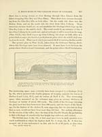
grounds for believing that there was. The whole of this district, as Dr
CHAMaERS explains, consists of "a mass of gravel 11 miles long hij j)erh(ps '1
broad, and reaching an elevation of m2 feet ahore the sea." I have traversed the
district in many directions, and can attest that it presents an enormous accumu-
lation of drift deposits, — not gravel only, but also of sand and clay ; — at one
spot only does rock come to the surface. Streams cut through this extensive
drift jjlateau fi'om the Aonachmore hills, situated to the south. There arc no
less than five mountain torrents in the course of two miles in this part
of the district. These streams present deep gashes through the detritus,
and when they reach the base of the hilly range, unite into considerable
rivers, which run, some north to join the Spean, others west towards Fort-
William. The scouring out of detritus along the base of these hills has been
very great. The result has been a valley deep and wide in an east and
west direction. In company with the Rev. Mr Cameron, minister of " the
parish, I w'alked along this valley towards Fort- William. Part of it consists
of an elongated marsh, formerly a lake, whose margin had been about '10 feet
al)Ove the marsh, the surrounding cliffs being detritus. Farther west I came
upon a small lake, the banks of which, composed of detritus, are about 170 feet
high, showing on their sides two or three terraces, proofs that either the lake
liad suljsided from one level to another, or that the river had eroded first on one
side and then on another at the aliove levels before reaching its present channel.
The river has now leached rock, so that further subsidence is arrested.
In different parts of this lower district, knolls and banks of d(>tritus stand
up above the general level. It would therefore require no great amount of
restoration to supply a detrital l)l(jckage sulHcient for damming the great lake
indicated by the lowest Glen Roy shelf, which is 854 feet ajjovc the sea.
* I havo already explained, that the subsidence of the lake fi'oin Shelf 3 to 4 did not take place
all at once. It .sank at llr.st only about 78 feet, and formed an intermediate road visible iu Glen
■Collarig, at its north end, on both sides.
the lake fell to Shelf 3, the waters in Cileii C'ollarig reached to C iu fig. 10, and
thereafter, on the removal of the blockage between Craig Dhu and Bohunthie,
the waters of the lowest shelf came up Glen Collarig to the place (viz., D),
where the detrital blockage above referred to existed.
When the lake sank to the lowest shelf '*''■ (Xo. 4) iu the glens, Ijy the removal
of the lilockage between Bohina and Bohuntine, the waters of the lake occupied
the whole valley of the Spean. Shelf 4 is traceable as far as the east end of
Loch Laggan ; and towards the west to Teindrish on the one side and Corry
Cholzie and Corry N'Eoin on the other side.
And what was the blockage at this point ? The intervening space Ijetween
the two shelves at this their Western termination is no less than five miles in
length. Could there have been a detrital liarrier here also ? There are good
grounds for believing that there was. The whole of this district, as Dr
CHAMaERS explains, consists of "a mass of gravel 11 miles long hij j)erh(ps '1
broad, and reaching an elevation of m2 feet ahore the sea." I have traversed the
district in many directions, and can attest that it presents an enormous accumu-
lation of drift deposits, — not gravel only, but also of sand and clay ; — at one
spot only does rock come to the surface. Streams cut through this extensive
drift jjlateau fi'om the Aonachmore hills, situated to the south. There arc no
less than five mountain torrents in the course of two miles in this part
of the district. These streams present deep gashes through the detritus,
and when they reach the base of the hilly range, unite into considerable
rivers, which run, some north to join the Spean, others west towards Fort-
William. The scouring out of detritus along the base of these hills has been
very great. The result has been a valley deep and wide in an east and
west direction. In company with the Rev. Mr Cameron, minister of " the
parish, I w'alked along this valley towards Fort- William. Part of it consists
of an elongated marsh, formerly a lake, whose margin had been about '10 feet
al)Ove the marsh, the surrounding cliffs being detritus. Farther west I came
upon a small lake, the banks of which, composed of detritus, are about 170 feet
high, showing on their sides two or three terraces, proofs that either the lake
liad suljsided from one level to another, or that the river had eroded first on one
side and then on another at the aliove levels before reaching its present channel.
The river has now leached rock, so that further subsidence is arrested.
In different parts of this lower district, knolls and banks of d(>tritus stand
up above the general level. It would therefore require no great amount of
restoration to supply a detrital l)l(jckage sulHcient for damming the great lake
indicated by the lowest Glen Roy shelf, which is 854 feet ajjovc the sea.
* I havo already explained, that the subsidence of the lake fi'oin Shelf 3 to 4 did not take place
all at once. It .sank at llr.st only about 78 feet, and formed an intermediate road visible iu Glen
■Collarig, at its north end, on both sides.
Set display mode to: Large image | Transcription
Images and transcriptions on this page, including medium image downloads, may be used under the Creative Commons Attribution 4.0 International Licence unless otherwise stated. ![]()
| Early Gaelic Book Collections > J. F. Campbell Collection > On the parallel roads of Lochaber > (36) |
|---|
| Permanent URL | https://digital.nls.uk/80970442 |
|---|
| Description | By David Milne Home. From the Transactions of the Royal Society of Edinburgh, vol. XXVIII. |
|---|---|
| Shelfmark | Cam.1.a.1(1) |
| Additional NLS resources: | |
| Attribution and copyright: |
|
| Description | Volumes from a collection of 610 books rich in Highland folklore, Ossianic literature and other Celtic subjects. Many of the books annotated by John Francis Campbell of Islay, who assembled the collection. |
|---|
| Description | Selected items from five 'Special and Named Printed Collections'. Includes books in Gaelic and other Celtic languages, works about the Gaels, their languages, literature, culture and history. |
|---|