Download files
Complete book:
Individual page:
Thumbnail gallery: Grid view | List view

D. MILNE HOME ON THE PARALLEL ROADS OF LOCHABER. 597
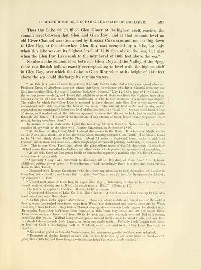
Thus the Lake which filled Glen Gluoy at its highest shelf, reachetl the
summit level between that Glen and Glen Roy; and at that summit level an
old Eiver Channel was discovered by Egbert Chambers and me, leading down
to Glen Roy, at the timewhen Glen Roy was occupied by a lake, not only
when this lake was at its highest level of 1149 feet above the sea, but also
when the Glen Roy Lake sank to the next level of 1068 feet above the sea."
So also at the summit level between Glen Roy and the Valley of the Spey,
there is a flattish hollow, exactly corresponding in level with the highest shelf
in Glen Roy, over which the Lake in Glen Roy when at its height of 1149 feet
above the sea could discharge its surplus waters.
* As this is a point of some iniportanoe, it is only fair to state, that a very experienced observer,
Professor Nicol of Aberdeen, does not admit that there is evidence of a River Channel from any one
Glen into another Glen. Ho says (" London Geol. Sooy. Journal," May 12, 1869, page 28-4) "I examined
the various passes carefully, and found that whilst in none of them was there the slightest trace of an
ancient river, in all there were distinct indications of the former existence of a narroio Sea Strait."
The valley by which the Gluoy Lake is assumed to have drained into Glen Roy is very narrow, and
encumbered with detritus from the hills on the sides. The summit level is flat and marsliy, and it
appeared to me considerably below the level of the line (i.e., the 'Road' ?). On the other hand, a line
of stones, as if washed out of the detritus, appeared to show that the sea or loch, had extended quite
through the Strait. I observed no indication of any stream of water, larger than the present small
rivulet, having ever been there."
In answer to these statements, I give the following Extracts from the Notes made by me on the
occasion of my visit to the place with Robert Chambers, in September 1846.
" At the head of Glen Gluoy, .Shelf 1 almost disappears in the Moss. It is however faintly visible
on the North side, about 1 or 2 feet above the Moss, running towards Glen Turrit. The ^Moss I found
to be 5i feet thick above Boulder Clay. About li miles to Eastward, found rocks in middle of
Channel, much worn and smoothed, — their rough edges or faces all pointing Eastward, i.e., towards Glen
Roy. This is near Glen Turrit, and about the place where traces of Shelf 1 disappear. About 8 or
10 feet above these smoothed rocks there are other rocks which present no appearance of smoothing.
"At the side, there are low grassy knolls or hummocks apparently marking edge of a River Course, —
which here 40 yards wide.
"Apparently Gluoy Lake continued to discharge, whilst Roy dropped from Shelf 2 to 3, hence
additional cutting power given to Gluoy Stream ; — and accordingly there is a deep and rocky ravine,
down to Glen Turret.
•'Measured with Robert Chambers (who first drew my attention to fact) depression of Shelf 2 in
Glen Roy below Shelf 1, and found that by Spirit-lefelliny, it was 29 feet ; by Sijmpysometer 35 feet;
by Barometer 1 1 feet.
" Visited next, head of Glen Roy, in upper Glen Roy. Interesting to observe how imiformly the
smooth surfaces of rocks are to West, the rough faces to East." (Notes p. 47).
The foUowing applies to the Glen Glaster old River course.
" Discovered debouche of Lake No. 3 in Glen Glaster. A Shelf on both sides runs up to Col, at a
level coincident with Moor there.
" At this place, rocks appear above moss. These are about middle and lowest part of fiat. — Evi-
dently, water has rushed over these rocks from ^Yest : for their round and smooth faces are to West,
then- rough faces to East. They form a Channel sloping down towards Loch Laggan for about a mile.
By existing bum, they can't have been rounded, as this burn, very small, and 20 feet below them.
These rocks occupy a breadth of from 30 to 40 feet, and have evidently occupied bed of a stream,
exceeding that width. Walked along this supposed ancient \rater-course for about a nnle, and saw that
it extended down towards Loch Laggan, as far as eye could reach. Probably Loch Laggan then stood
at level of Shelf 4, discharging itself at ilukkoul, as it continued to do, when Lake Rov sunk to
Shelf 4.
" No sand or gravel in this old Water-course, but numerous granite boulders, very spherical.
" Remnants of sloping haughs on each side, evidently formed by old River when in flood, — with
precipitous cliffs beyond these haughs, — indicating height to which floods reached."
Set display mode to: Large image | Transcription
Images and transcriptions on this page, including medium image downloads, may be used under the Creative Commons Attribution 4.0 International Licence unless otherwise stated. ![]()
| Early Gaelic Book Collections > J. F. Campbell Collection > On the parallel roads of Lochaber > (21) |
|---|
| Permanent URL | https://digital.nls.uk/80970262 |
|---|
| Description | Volumes from a collection of 610 books rich in Highland folklore, Ossianic literature and other Celtic subjects. Many of the books annotated by John Francis Campbell of Islay, who assembled the collection. |
|---|
| Description | Selected items from five 'Special and Named Printed Collections'. Includes books in Gaelic and other Celtic languages, works about the Gaels, their languages, literature, culture and history. |
|---|

