Download files
Complete book:
Individual page:
Thumbnail gallery: Grid view | List view

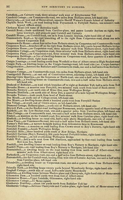
36 NEW DIRECTORY TO SUBURBS.
Cattofield — on Cairncry-road, three minutes' walk west of Kittybrewster Toll
Canefield Cottage — on Countesswells-road, two miles from Holburn-street, left-hand side
Cherryvale — at west end of Skene-street, opposite Sheriff Watson's Female School of Industry
Clayhills Brick Work — on road leading from Poynernook to Ferry hill Station, one minute's walk
beyond Affleck-street
Clerkseat Road (old name of Berryden-road)
Cornhill Road — .leads northward from Caroline-place, and passes Lunatic Asylum on right, then
turns westward, and proceeds past Cornhill and Cairncry
Cornhill House~~on Cornhill-road, one nrle from Lunatic Asylum, right-hand side of road
Countesswells Road~_a by-road branching off to the right from Cooperston-road, about one mile
beyond Cooperston Toll
Countesswells House — about four miles from Holburn-street, by Cooperston, and Countesswells-roads
Cooperston Road — branches off on the right from Holburn-street, fifty yards beyond Holburn-bridge
Cooperston House — on Cooperston-road, three minutes' walk from Holburn-street, right-hand side
Cooperston Cottage — on Cooperston-road, three minutes' walk from Holburn-street, right-hand side
Cooperston Place — on Cooperston-road, three minutes' walk from Holburn-street, right-hand side
Cooperston Buildings~~a line of dwelling-houses on Cooperston-road, three quarters of a mile from
Holburn-street, right-hand side
Craigie Loanings — a road leading north from Westfield or foot of Albert-street to High Stocket-road
Craigie Park — a dwelling-house on the Craigie-loanings-road, left-hand side (see Craigie-loanings)
Craigiebuckler — between the Rubislaw and Countesswells-roads, one -and -a-half miles from Holburn-
street
Craigton Cottage — on Countesswells-road, two miles from Holburn-street, left-hand side
Cunnigerhill Nursery — at east end of Constitution-street, adjoining Links, left-hand side
Dancing Cairn Quarries — on the Inverness or North-road, one-and-a-half miles beyond Woodside
Dairncleugh — a dwelling-house on Countesswells-road, two-and-a-half miles from Holburn-street,
left-hand side
Denhead of Rubislaw — on road which branches off to right at Rubislaw Toll, half-a-mile from Toll
Devanha House— a mansion near Ferryhill, two minutes' walk south from head of Bank-street
Devanha Brewery ^~on north side of River Dee, near Wellington Bridge
Devanha Distillery — on north side of River Dee, a quarter-of-a-mile beyond Wellington Bridge
Devanha Terrace — leads south from head of Bank-street
Dee Mouth — at south end of College-street, left-hand side
Dee Mount — a dwelling-house about a hundred yards west from Ferryhill Station
Dee Village — at south end of Crown-street, on left-hand side
Diamond Cottage, Holhurn-place—south end of Holburn-street, left-hand side
Dry well Park — on the Stocket-road leading past Rosemount, nearly opposite head of Short-loanings
Eastfield — on the Low Stocket-road, one-and-a-quarter miles from Caroline-place, left-hand side
Eden Cottage — on Countesswells road, two-and-a-half miles from Holburn-street, left-hand side
Elmhill — a mansion on the Cornhill-road, five minutes' walk from Caroline-place, right-hand side
Elmfield — a dwelling house on canal side, half-a-mile above Mounthooly, east side of canal
Ewan Place — on Countesswells-road, two-and-a-half miles from Holburn-street, left-hand side
Farmer's Hall-lane — a narrow footpath leading from Gilcomston-brae to Rosemount
Ferryhill House — a mansion on road leading from Crown-street to Roy's Nursery, right-hand side
Ferryhill Foundry ™.beside Wellington Bridge
Ferryhill Mills — three hundred yards south of New Bridge, Hardgate
Ferryhill Gardens (Roy's Nursery), 300 yards beyond Ferryhill-house, right-hand side
Ferryhill Cottage~~.on hill overlooking Wellington Bridge *
Firhill Well — half-a-mile west from OJd Aberdeen, approached by foot-road leading from beside
Red Lion Inn, Spittal
Fonthill — two dwelling houses on road leading from Roy's Nursery to Hardgate, right-hand side
Fonthill Place — on road leading from Roy's Nursery to Hardgate, left-hand side
Fountainhall — a dwelling house on the road leading west from north end of Albert-street, four
minutes' walk from Albert-street, right-hand side
Forbesfield — .on Cooperston-road, one-and-a-half miles from Holburn-street, right-hand side
Forresterhill — .on the Cornhill-road, leading from west side of Lunatic Asylum, one-and-a-half miles
from Caroline-place, left-hand side
Friendville — a dwelling house on Cooperston-road, one-and-a-quarter miles from Holburn-streetj
right-hand side
Friendly Bank — a dwelling house twenty yards beyond Mounthooly Bridge, right-hand side
Froghall Cottage — north side of canal, half-a-mile above Mounthooly
Galleries — a dwelling house between Mackie-place and Cherryvale, right-hand side of Skene-street
Gilcomston Dam — a hundred yards west from foot of Albert-street
Gilcomston House — Upper Leadside, Gilcomston, right-hand side
Gilcomston Cottage — 31 Skene-square
Glenburnie Distillery — about 100 yards north from Rubislaw Toll-bar
Glenburnie Cottage — between Cherryvale and Carden-place, right-hand side of Skene-street-west
Set display mode to: Large image | Transcription
Images and transcriptions on this page, including medium image downloads, may be used under the Creative Commons Attribution 4.0 International Licence unless otherwise stated. ![]()
| Scottish Post Office Directories > Towns > Aberdeen > Cornwall's new Aberdeen directory > (42) |
|---|
| Permanent URL | https://digital.nls.uk/86301697 |
|---|
| Description | Directories of individual Scottish towns and their suburbs. |
|---|
| Description | Around 700 Scottish directories published annually by the Post Office or private publishers between 1773 and 1911. Most of Scotland covered, with a focus on Edinburgh, Glasgow, Dundee and Aberdeen. Most volumes include a general directory (A-Z by surname), street directory (A-Z by street) and trade directory (A-Z by trade). |
|---|


