Download files
Complete book:
Individual page:
Thumbnail gallery: Grid view | List view

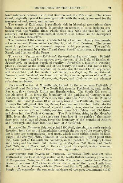
DESCRIPTION OF THE COUNTY. 21
brief intervals between Leith and Granton and the Fife coast. The Union
Canal, originally opened for passenger traffic with the west, is now used for the
transport of coal, stone, and manure.
The county of Edinburgh is peculiarly rich in historical associations, there
being scarcely a spot not made interesting on account of some incident con-
nected with the warlike times which close only with the first half of last
century ; but the more prominent of these will be noticed in the description
of the localities themselves.
The business of the county is conducted by a Lord and Deputy Lieutenants,
a Convener and Commissioners of (Supply, and Eoad Trustees. The assess-
ment for police and county-court purposes is 5d. per pound. The judicial
business is managed by a Sheriff and three Sheriff-substitutes, a Procurator-
Fiscal, and Justices of the Peace.
Towns and Villages. — Edinburgh, the capital and a royal burgh; Dalkeith,
a burgh of barony and busy market-town, the seat of the Duke of Buccleuch ;
Musselburgh, an ancient burgh of regality ; Portobello, a favourite watering-
place ; Penicuik, at the south end. of the county, the seat of Sir James Clerk,
where there are extensive paper-mills ; Mid-Culder, the seat of Lord Torphichen,
and West-Calder, at the western extremity ; Corstorphine, Currie, Eskbank,
Lasswade, and Loanhead, are favourite country summer quarters of the Edin-
burgh citizens ; Trinity, Momingside, Joppa, and Duddingston are pleasant
suburban residences.
Rivers. — The Esk, at Musselburgh, formed by the union near Dalkeith of
the North and South Esk. The North Esk rises in Peeblesshire, and, passing
Penicuik, flows through Roslin and Hawthornden. The South Esk rises in
the Moorfoot Hills, forms the boundary of the parishes of Carrington and
Borthwick, flows through Newbattle, and joins the North Esk in Dalkeith
Park. The Water of Leith, 19 miles long, rises in the Pentlands, and, flowing
through the villages of Balerno, Currie, Colinton, and Slateford, falls into the
harbour at Leith. The Almond, a good trouting river, rises in Lanarkshire,
divides the county from Linlithgowshire, passes Mid-Calder and Kirkliston,
and flows into the Firth at Cramond. The Gala Water, rising in the Moorfoot
Hills, joins the Heriot at the north-east boundary of the parish of that name,
flows past the village of Stow, forms the boundary of the counties of Selkirk
and Roxburgh, and flows into the Tweed at Abbotsford.
Hills. — The Pentlands (highest point 1890 feet), stretch, in a north-easterly
direction, from the east of Lanarkshire through the centre of the county, divid-
ing it into two comparatively level tracts, which unite within 5 miles of Edin-
burgh ; the Moorfoot Hills, a branch of the Lammermoors (highest point 2136
feet), form part of the southern boundary, in the parishes of Temple, Heriot,
and Stow ; and the small but interesting Corstorphine Hill, Braid and Black-
ford Hills, and Arthur's Seat, in the vicinity of tbe capital, which command
varied and extensive views of the surrounding country.
Antiquities and Places op Interest. — Borthwick Castle, about 2 miles
south-east of the Fushiebridge station of the North British Railway ; the ruins
of Craigmillar Castle, on the old Dalkeith Road, about 3 miles from Princes
Street ; the ruins of Crichton Castle, in the valley of the Tyne, 1 mile from
Borthwick Castle ; Roslin, with its Chapel and Castle, 1\ miles south of Edin-
burgh ; Hawthornden, the romantic residence of the poet Drummond (1585-
Set display mode to: Large image | Transcription
Images and transcriptions on this page, including medium image downloads, may be used under the Creative Commons Attribution 4.0 International Licence unless otherwise stated. ![]()
| Scottish Post Office Directories > Counties > Midlothian (Edinburghshire) > Edinburgh county directory > (27) |
|---|
| Permanent URL | https://digital.nls.uk/85990459 |
|---|
| Description | Directories of individual Scottish counties or parts of counties. |
|---|
| Description | Around 700 Scottish directories published annually by the Post Office or private publishers between 1773 and 1911. Most of Scotland covered, with a focus on Edinburgh, Glasgow, Dundee and Aberdeen. Most volumes include a general directory (A-Z by surname), street directory (A-Z by street) and trade directory (A-Z by trade). |
|---|


