Towns > Dundee > 1809-1912 - Dundee directory > 1880-1881
(27)
Download files
Complete book:
Individual page:
Thumbnail gallery: Grid view | List view

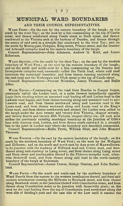
C 5 )
MUNICIPAL WARD BOUNDARIES
AND THEIR COUNCIL REPRESENTATIVES.
Ward First— On the east by the eastern boundary of the burgh ; on the
south by the river Tay ; on the west by a line commencing at the top of Castle
street, and thence southward along Castle street to Dock street, and thence
southward to the Victoria arch at the harbour of Dundee, and thence through
the centre of said arch in a straight line southward to the river Tay; and on
the north by Murraygate, Cowgate, King street, Princes street, and the Dundee
and Arbroath turnpilce road to the eastern boundary of the burgh.
Council Representatives— John Adamson, Andrew G. Kidd, and James
Robertson.
Ward Second. — On the south by the river Tay ; on the east bj' the western
boundary of Ward First; on the west by the western boundary of the burgh;
and on the north and north-west by a line commencing on the Dundee and
Invergowrie turnpike road, commonly called the Perth road, where said road
intersects the municipal boundary, and from thence running eastward along
the said road and the Nethergate and High street to the top of Castle street.
Council Representatives — Provost Brownlee, James Thomson, and Bailie
Allan.
Ward Third.— Commencing on the road from Dundee to Coupar Angus,
commonly called the Lochee road, at a point thereon immediately opposite
Logie farm steading where an unnamed road leading off said Lochee road to the
Lawside road begins, and from thence running along said unnamed road to sai<l
Lawside road, and from thence northward along said Lawside road to the
Loons road, and from thence westward along said Loons road to the King's
Cross road, and from thence northwards and around the Lochee area, added to
the burgh under the Acts twenty and twentj'-first Victoria, chapter seventy,
and twenty-fourth and twenty-fifth Victoria, chapter thirty-six, till such area
strikes the previousl)'^ existing municipal boundary at the junction of Gibb's
lane with Anerum road, Lochee, and from thence south-eastward in a straight
line to the point in Lochee road where the boundary now described commenced.
Council Representatives— Bailie Perrie, William Blair, and John Mustard
Thomson.
Ward Fourth —On the east by the eastern boundary of the burgh ; on the
south by the northern boundary of Ward First ; on the west by the Wellgate
and Hilltown ; and on the north and north-east by Ann street of Maxwelltown,
to its junction with the roadway of Hillbank road and Cotton road, and from
thence along raid roadway to Laing street, and from thence along Laing street
and Dura street and continuation thereof to the Pitkerro turnpike road, other-
wise Stobswell road, and from thence along said road to the north-easterly
boundary of the burgh at Stobsmuir.
Council Representatives— James Cowan, George Duncan, and John Suther-
land.
Ward Fifth,— On the south and south-east by the northern boundary of
Ward Fourth from the eastern to the western termination thereof, and from said
western termination crossing the Hilltown to Rosebank street, and from thence
along Rosebank street, to the junction thereof with Constitution street, and from
thence along Constitution street to its junction with Somerville place; on the
west by the road leading from the top of Constitution road northward along the
west side of Stirling's park and the east side of the Law until it reaches the
Set display mode to: Large image | Transcription
Images and transcriptions on this page, including medium image downloads, may be used under the Creative Commons Attribution 4.0 International Licence unless otherwise stated. ![]()
| Scottish Post Office Directories > Towns > Dundee > Dundee directory > 1880-1881 > (27) |
|---|
| Permanent URL | https://digital.nls.uk/85898324 |
|---|
| Description | Imprint varies. |
|---|---|
| Shelfmark | Various |
| Description | Directories of individual Scottish towns and their suburbs. |
|---|
| Description | Around 700 Scottish directories published annually by the Post Office or private publishers between 1773 and 1911. Most of Scotland covered, with a focus on Edinburgh, Glasgow, Dundee and Aberdeen. Most volumes include a general directory (A-Z by surname), street directory (A-Z by street) and trade directory (A-Z by trade). |
|---|


