Download files
Complete book:
Individual page:
Thumbnail gallery: Grid view | List view

50
EE-DIVIDED AND ALTERED WARDS,
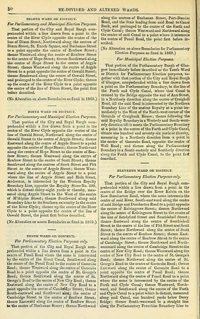
EIGHTH WARD OR DISTRICT.
For Parliamentary and Municipal Election Purposes.
That portion of the City and Royal Burgh com-
prehended within a line drawn from a point in the
centre of the River Clyde opposite the centre of the
line of Dixon Street, Northward along the centres of
Dixon Street, St. Enoch Square, and Buchanan Street
to a point opposite the centre of Renfrew Street ;
thence Westward along the centre of Renfrew Street
to the centre of Hope Street; thence Southward along
the centre of Hope Street to the centre of Argyle
Street; thence Westward along the centre of Argyle
Street to a point opposite the centre of Oswald Street ;
thence Southward along the centre of Oswald Street,
and prolonged to the centre of the River Clyde ; thence
up the centre of the River Clyde to a point opposite
the centre of the line of Dixon Street, the point first
before described.
(No Alteration on above Boundaries as fixed in 1869.)
NINTH WARD OR DISTRICT.
For Parliamentary and Municipal Election Purposes.
That portion of the City and Royal Burgh com-
prehended withiD a line drawn from a point in the
centre of the River Clyde opposite the centre of the
line of Oswald Street, Northward along the centre of
Oswald Street to the centre of Argyle Street; thence
Eastward along the centre of Argyle Street to a point
opposite the centre of Hope Street ; thence Northward
along the centre of Hope Street to the centre of Ren-
frew Street; thence Westward along the centre of
Renfrew Street to the centre of Scott Street ; thence
Southward along the centres of Scott Street and Pitt
Street to the centre of Argyle Street ; thence West-
ward along the centre of Argyle Street to a point
vhere the line of Argyle Street and Main Street,
Anderston, is intersected by the Western Royalty
Boundary Line, opposite the Royalty Stone No. 209,
which is distant thirty-eight yards or thereby, mea-
sured along Argyle Street to the West of the centre
of M'Alpine Street; thence Southward along said
Boundary Line to its Southern extremity in the centre
of the River Clyde ; thence up the centre of the River
Clyde to a point opposite the centre of the line of
Oswald Street, the point first hefore described.
(No Alteration on aoove Boundaries as fixed in 1869.)
TENTH WARD OR DISTRICT.
For Parliamentary Election Purposes only.
That portion of the City and Royal Burgh com-
prehended within a line drawn from a point in the
centre of Possil Road where the same is intersected
by the centre of the Great Canal, Southward along
the centre of the Possil Road to the centre of Garscube
Road ; thence Westward along the centre of Garscube
Road to a point opposite the centre of St. George's
Road; thence Southward along the centre of St.
George's Road to the centre of New City Road ; thence
Eastward along the centre of New City Road to a
point opposite the centre of Cambridge Street; thence
South-eastward and Southward along the centre of
Cambridge Street to the centre of Renfrew Street;
thence Eastward along the centre of Renfrew Street
to the centre of Buchanan Street ; thence Northward
along the centres of Buchanan Street, Port-Dundas
Road, and the Stair leading from said Road to Canal
Bank, and prolonged to the centre of the Forth and
Clyde Canal ; thence Westward and Northward along
the centre of said Canal to a point where it intersects
the centre of Possil Road, the point first before de-
scribed.
(No Alteration on above Boundaries for Parliamentary
Election Purposes as fixed in 1869.)
For Municipal Election Purposes.
That portion of the Parliamentary Burgh of Glas-
gow immediately before described as the Tenth Ward
or District for Parliamentary Election purposes, to-
gether with that portion of the City and Royal Burgh
of Glasgow, comprehended within a line drawn from
a point on the Parliamentary Boundary, in the line of
the Forth and Clyde Canal, where that Canal is
crossed by the Bridge opposite the end of Ann Street,
in a Northerly direction along the centre of Craighall
Road, till the said Road is intersected by the Northern
Boundary Line of the aneient Royalty at a point im-
mediately to the West of the North-west corner of the
Grounds of Craigbank House ; thence following the
said Royalty Boundary in a Westerly and South-west-
erly direction till it meets the Parliamentary Boundary
at a point in the centre of the Forth and Clyde Canal,
situate one hundred and seventy-six yards or thereby,
measuring in a Northerly direction from a point in
the centre of Garscube Road, opposite the centre of
Well Road ; and thence along the Parliamentary
Boundary in a South-easterly and Southerly direction
along the Forth and Clyde Canal, to the point first
described.
ELEVENTH WARD OR DISTRICT.
For Parliamentary Election Purposes only.
That portion of the City and Royal Burgh com-
prehended within a line drawn from a point in the
centre of the Bridge over the River Kelvin on the
New Dumbarton Road, where the same intersects the
centre of said River, South-eastward along the centre
of said Bridge and Dumbarton Road to a point opposite
the centre of Kelvingrove Street ; thence Northward
along the centre of Kelvingrove Street to the centre of
the line of Sandyford Street and Sauchiehall Street ;
thence Eastward along the centre of Sauchiehall
Street to the centre of the line of Pitt Street and Scott
Street ; thence Northward along the centre of Scott
Street to the centre of Renfrew Street ; thence East-
ward along the centre of Renfrew Street to the centre
of Cambridge Street ; thence Northward and North-
westward along the centre of Cambridge Street to the
centre of New City Road ; thence Westward along the
centre of New City Road to the centre of St. George's
Road; thence Northward along the centre of St.
George's Road to the centre of Garscube Road ; thence
Eastward along the centre of Garscube Road to a
point opposite the centre of Possil Road ; thence
Northward along the centre of Possil Road to a point
where the same is intersected by the centre of the
Forth and Clyde Canal; thence Westward, North-
ward, and Southward along the centre of the Forth
and Clyde Canal to a point which is distant, measured
along said Canal, one hundred yards below Derry
Bridge; thence South-westward in a straight line
along the Parliamentary Franchise Boundary Line to
Set display mode to: Large image | Transcription
Images and transcriptions on this page, including medium image downloads, may be used under the Creative Commons Attribution 4.0 International Licence unless otherwise stated. ![]()
| Scottish Post Office Directories > Towns > Glasgow > Post-Office annual Glasgow directory > 1879-1880 > (62) |
|---|
| Permanent URL | https://digital.nls.uk/84460253 |
|---|
| Description | Directories of individual Scottish towns and their suburbs. |
|---|
| Description | Around 700 Scottish directories published annually by the Post Office or private publishers between 1773 and 1911. Most of Scotland covered, with a focus on Edinburgh, Glasgow, Dundee and Aberdeen. Most volumes include a general directory (A-Z by surname), street directory (A-Z by street) and trade directory (A-Z by trade). |
|---|


