Download files
Complete book:
Individual page:
Thumbnail gallery: Grid view | List view
THE POST-OFFICE
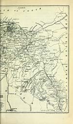
PLAN OF EDINBURGH AND LEITH.
BY JOHN BABTHOLOMEW, F.R.G.S.
Brought up to the latest date, may be had in the following forms : —
In Sheet, plain or folded in Paper Cover . . Is. Od.
Coloured into the new Municipal Wards or Parishes Is. 6d.
Mounted on Cloth, Rollers, wnd Varnished, Is. 6d. extra.
Sold by J. Babtholomew, 17 Brown Square.
THE MERCANTILE MAP OF THE WORLD,
ON MEECATOE'S PEOJEOTION.
BY JOHN BAETHOLOMEW. F.R.G.S.
Size 56 X 40 in.
Exhibiting all the latest Geographical Discoveries — all the States, Kingdoms, and
Empires of the World, with their Seaports and Chief Towns — Ocean Steamer and
Sailing Vessel Routes, with Distances in MJles and Time in Days — Principal Rail-
ways, Submarine and Overland Telegraphs — Ocean Cturents — Time of Day at
different parts of the Globe when 12 o'clock at London — with 18 5tjaps of British
Colonies and Ports on enlarged scale.
Price, nwurded on Cloth and Roller for Wall, or in Cloth Case for Library, £1, \s
" Fit to ornament any office or library." — Scotsman.
" A real vade mecum for the merchant." — Glasgow Herald.
" It affords at a speedy glance, and posted up to date, the mercantile infonnation usually
found in books of reference." — London Daily Telegraph.
"Thi!! Map is a remarkably complete and beautlfnJ work. We fool no heaitatiou in .saying its
rival could Ijardly be found for combined cheapne«s and abundance of information." — Londun
Weekly Review.
" Will pi'ove an invaluable adjunct to any merchant's or shipowner's office. It is beautifully
printed and handsomely mounted." — Liverpool Mercurg.
Published by WiLtiAM Collins, Sons, & Co., Glasgow, Edinburgh, and London.
NEW SCHOOL MAP OF THE WORLD,
ON GAIL'S IMPROVED PEOJEOTION.
Size 6 ft. 6 in. x 4 ft. 7 in.
The Map is designed to supersede to some extent the use of special Wall Maps of
the Continents. The scale is such as to allow of aU the chief Physical and Geo-
graphical features of the ■warious Countries being efficiently shown, excepting in the
British Lslands and Central Europe, where greater minutise are required than can
be sho%vn in a general Map. The boxmdaries of the States are accurately defined,
and brought out by distinct colours ; while care has been taken to give those names
and details generally required in the tisual course of instruction. There are also
introduced many important features illustrative of Phjrsical Geography and Com-
merce.
Price, mounted on Cloth and RoUera, Full Coloured, £1, Is., or Varnished, £\, 5s,
Published by W. & R. Chambebs, London and Edinburgh.
Set display mode to: Large image | Transcription
Images and transcriptions on this page, including medium image downloads, may be used under the Creative Commons Attribution 4.0 International Licence unless otherwise stated. ![]()
| Scottish Post Office Directories > Towns > Edinburgh > Post Office Edinburgh and Leith directory > 1871-1872 > (38) |
|---|
| Permanent URL | https://digital.nls.uk/83182956 |
|---|
| Description | Post-Office Edinburgh & Leith directory 1871-72 |
|---|---|
| Shelfmark | POE |
| Additional NLS resources: | |
| Attribution and copyright: |
|
| Description | Edinburgh : Postmaster General, [1846-1975]. Preceded by: Edinburgh & Leith Post Office Directory Limited. |
|---|---|
| Shelfmark | Various |
| Description | Directories of individual Scottish towns and their suburbs. |
|---|
| Description | Around 700 Scottish directories published annually by the Post Office or private publishers between 1773 and 1911. Most of Scotland covered, with a focus on Edinburgh, Glasgow, Dundee and Aberdeen. Most volumes include a general directory (A-Z by surname), street directory (A-Z by street) and trade directory (A-Z by trade). |
|---|