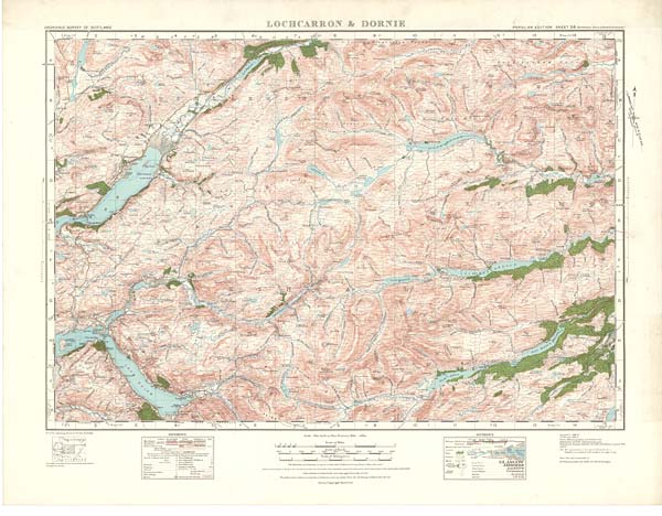
(36) Sheet 36 - Lochcarron & Dornie
Thumbnail gallery: Grid view | List view
Set display mode to: Large image | Zoom image
Images and transcriptions on this page, including medium image downloads, may be used under the Creative Commons Attribution 4.0 International Licence unless otherwise stated. ![]()
| Ordnance Survey One-Inch Popular edition of Scotland - 1921-1930 > (36) Sheet 36 - Lochcarron & Dornie |
|---|
| Permanent URL | https://digital.nls.uk/74558514 |
|---|---|
| Description | Sheet 36 of the Ordnance Survey One-inch Popular Edition of Scotland. It was issued in 1929 at a scale of 1 inch to 1 mile (1: 63,360) from a survey done between 1926 and 1928. The first Ordnance Survey of this area was done between 1866 and 1867. This sheet shows the area of mountains, lochs and sea inlets around Dornie and Lochcarron, in the north west of Scotland. On the right, the sheet stretches from Loch Airidh Lochain and Carn na Cre (1750 feet), in the north, to Loch na Beinne Baine and Carn a Choire Leith (2118 feet), in the south. On the left, the sheet stretches from a point just west of the southern end of Loch Damh, in the north, to Balavulin, in Glen More, in the south. On the right (east) of the sheet, the mountains are broken up by (from north to south) Am Fiar Loch, Loch na Caoidhe and the River Orrin, running from west to east, Loch a Mhuillidh, the River Farran and Loch Monar, running from north west to east, Loch Lungard, Loch Frith an Acha, Lochan na Cloiche, Loch Mullardoch, Loch a Bhana, Loch Sealbhanach, Loch Carrie and the River Cannich, running more or less from west to east, and Loch Affric, Loch an Laghair, Loch Beinn a Mheadhoin and the River Affric running from south west to north east. On the left (west), the sea inlet of Loch Carron runs in from the west, with Lochcarron at its head, and further south, the sea inlets of Loch Alsh and Loch Duich run in from the west, with Dornie at the head of Loch Alsh. There are two sets of References, the scale statement ‘One Inch to One Statute Mile - 1/63360’, with accompanying scale bar, and two other scale bars of 1 centimetre to 1000 yards and 1 centimetre to 1 kilometre. Contours and fathoms are shown, with accompanying information about measurement. |
| Description | A series of 92 sheets mapping all of Scotland. Ordnance Survey aimed to produce an attractive contoured road map that would be popular with the 'man in the street'. The ‘Popular’ edition was particularly intended for the inter-war generation's leisure hours – cycling, touring or walking through the countryside. |
|---|---|
| Shelfmark | Map Room |
| Additional NLS resources: |
|