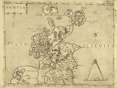
This is the first surviving printed map of Scotland portrayed on its own. Watermarks in the paper indicate Venetian origin, and it may have been engraved by Paolo Forlani, who was active in Venice during the 1560s and 1570s. Although the outline of the east coast is recognisable, the depiction of the west coast and islands shows how little was known about the shape of Scotland in the sixteenth century.
The map is based on an earlier outline of Scotland, first shown on a 1546 map of the British Isles probably compiled by George Lily, an English Roman Catholic cleric who had lived in Italy. The influence of Hector Boece's History of Scotland might be seen in the 70 placenames (out of 105 on the map) which also appear in his work, and in the figures XLIII and XXXI which were his imaginative idea of the number of Hebridean and Orcadian islands respectively.
The National Library of Scotland purchased the map in 1992 from the Royal Scottish Geographical Society, which was given the map in 1919. It was believed to be the only known copy, but further research has revealed a variant in the Netherlands, which lacks the title Scotia.
Anon. Scotia: Regno di Scotia. [Venice?, c.1570]. Map Library EMS.s.6A. Click for larger image
410mm