Robert Watson-Watt (1892-1973)
Weather and wireless
WATT—WEATHER AND WIRELESS
275
will take place from Daventry 5XX, and it must be hoped that
“listeners” will provide those responsible for the transmissions
with sufficient data on which to base a decision on the usefulness
of the experiment.
But, as I have indicated, the long-distance air navigator is
the man whose success and whose life alike depend on accurate
reporting and forecasting. The forecasters at the ground bases
may do much for him, but for the balanced interpretation and
utilisation of the forecast it is essential that he should examine
the highly concentrated data contained in the synoptic chart. He
must be meteorologist as well as navigator, and the ground organi-
sation on which he depends must, in addition to sending him general
inferences, forecasts, and further outlooks, place in his hands, in
mid-air, at least the synoptic data required for the preparation of
a weather chart, or preferably, on grounds of speedy assimilation,
the chart itself. Wireless alone can reach him, but it must reach
him with data hot from the observing network, and must be used
in such a way that the labour expended on board in preparing it
for use is reduced to an absolute minimum, in view of the other
preoccupations of the personnel. Up to now the aeroplane pilot
has had to be content with the limited information that can be
conveyed in a short Morse message or a radiotelephonic message
en clair, the airship navigator has had to draw his own synoptic
chart from selected and limited cipher data transmitted at low
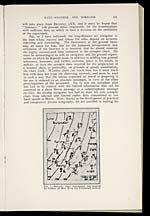
hand speeds in Morse. Now, thanks to the development of practical
and inexpensive picture telegraphy, we are justified in looking for
[NLS note: a graphic appears here – see image of page]
FIG. 1.—Synoptic chart transmitted and received
by wireless on Mar. 20 by the Fultograph method.
- © National Library of Scotland 2009
- NLS home page
- Digital library