Bannatyne Club > Origines parochiales Scotiae > Volume 2, part 1
(234) Page 204
Download files
Complete book:
Individual page:
Thumbnail gallery: Grid view | List view

204
ORIGINES
[knotdart.
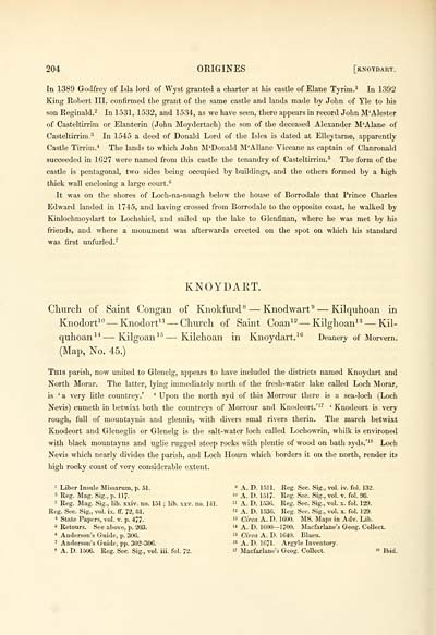
In 1389 Godfrey of Isla lord of Wyst granted a charter at his castle of Elane Tyrim.^ In 1392
King Eobert III. confirmed the grant of the same castle and lands made by John of Yle to his
son Reginald.- In 1531, 1532, and 1534, as we have seen, there appears in record John M'Alester
of Casteltirrim or Elanterin (John Moydertach) the son of the deceased Alexander M'AJane of
Casteltirrim.3 In 1545 a deed of Donald Lord of the Isles is dated at Elleytarne, apparently
Castle Tirrim.* The lands to which John M'Donald M'AUane Viceane as captain of Clanronald
succeeded in 1627 were named from this castle the tenandry of Casteltirrim.' The form of the
castle is pentagonal, two sides being occupied by buildings, and the others formed by a high
thick wall enclosing a large court.*^
It was on the shores of Locli-na-nuagh below the house of Borrodale that Prince Charles
Edward landed in 1745, and having crossed from Borrodale to the opposite coast, he walked by
Kinlochmoydart to Lochshiel, and sailed up the lake to Glenfinan, where he was met by his
friends, and where a monument was afterwards erected on the spot on which his standard
was first unfurled.'
KNOYDART.
Church of Saint Congan of Knokfurd^ — Knodwart' — Kilquhoan in
Knodort^" — Knodort^^ — Chuixh of Saint Coan^^ — Kilghoan'^ — Kil-
quhoan'* — Kilgoan'° — Kilchoan in Knoydart.'® Deanery of Morvern.
(Map, No. 45.)
This parish, now united to Glenelg, appears to have included the districts named Knoydart and
North Morar. The latter, lying immediately north of the fresh-water lake called Loch Morar,
is ' a very litle coimtrey.' ' Upon the north syd of this Morrour there is a sea-loch (Loch
Nevis) cumeth in betwixt both the countreys of Morrour and Knodeort.''^ ' Knodeort is very
rough, full of mountaynis and glennis, with divers smal rivers therin. The march betwixt
Knodeort and Gleueglis or Glenelg is the salt-water loch called Lochowrin, whilk is environed
with black mountayns and uglie rugged steep rocks with plentie of wood on bath syds.'^^ Loch
Nevis which nearly divides the parbh, and Loch Houi'n which borders it on the north, render its
high rocky coast of very considerable extent.
' Liber Insnle Missarum, p. 51.
' Reg. Mag. Sig., p. 117-
' Keg. Mag. Sig., lib. xxiv. no. 151 ; lib. xxv. no. 141.
Keg. Sec. Sig., vol. ix. ff. 72, 81.
' State Papers, vol. v. p. 477.
' Retonrs. See above, p. 203.
' Anderson's Guide, p. 306.
' Anderson's Guide, pp. 302-306.
« A. D. 1506. Reg. Sec. Sig., vol. iii. fol. 72.
» A. D. 1511. Reg. Sec. Sig., vol. iv. fol. 132.
A. D. 1517. Reg. Sec. Sig., vol. v. fol. 98.
A. D. 1536. Keg. Sec. Sig., vol. x. fol. 129.
2 A. D. 1536. Keg. Sec. Sig., vol. x. fol. 129.
' Circa A. D. 1600. MS. Maps in Adv. Lib.
1 A. D. 1600—1700. Macfarlane's Geog. Collect.
5 Circa A. D. 1640. Blaeu.
" A. D. 1671. Argyle Inventory.
' Macfarlane's Geog. Collect. " Jbid.
Set display mode to: Large image | Transcription
Images and transcriptions on this page, including medium image downloads, may be used under the Creative Commons Attribution 4.0 International Licence unless otherwise stated. ![]()
| Publications by Scottish clubs > Bannatyne Club > Origines parochiales Scotiae > Volume 2, part 1 > (234) Page 204 |
|---|
| Permanent URL | https://digital.nls.uk/81020591 |
|---|
| Description | Place of publication Edinburgh unless otherwise stated. No. 125 is relative to but not part of the club's series. |
|---|---|

