Unst -- Yetholm
(343) Page 5
Download files
Complete book:
Individual page:
Thumbnail gallery: Grid view | List view
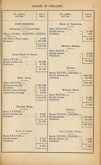
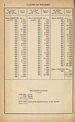
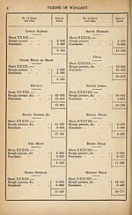
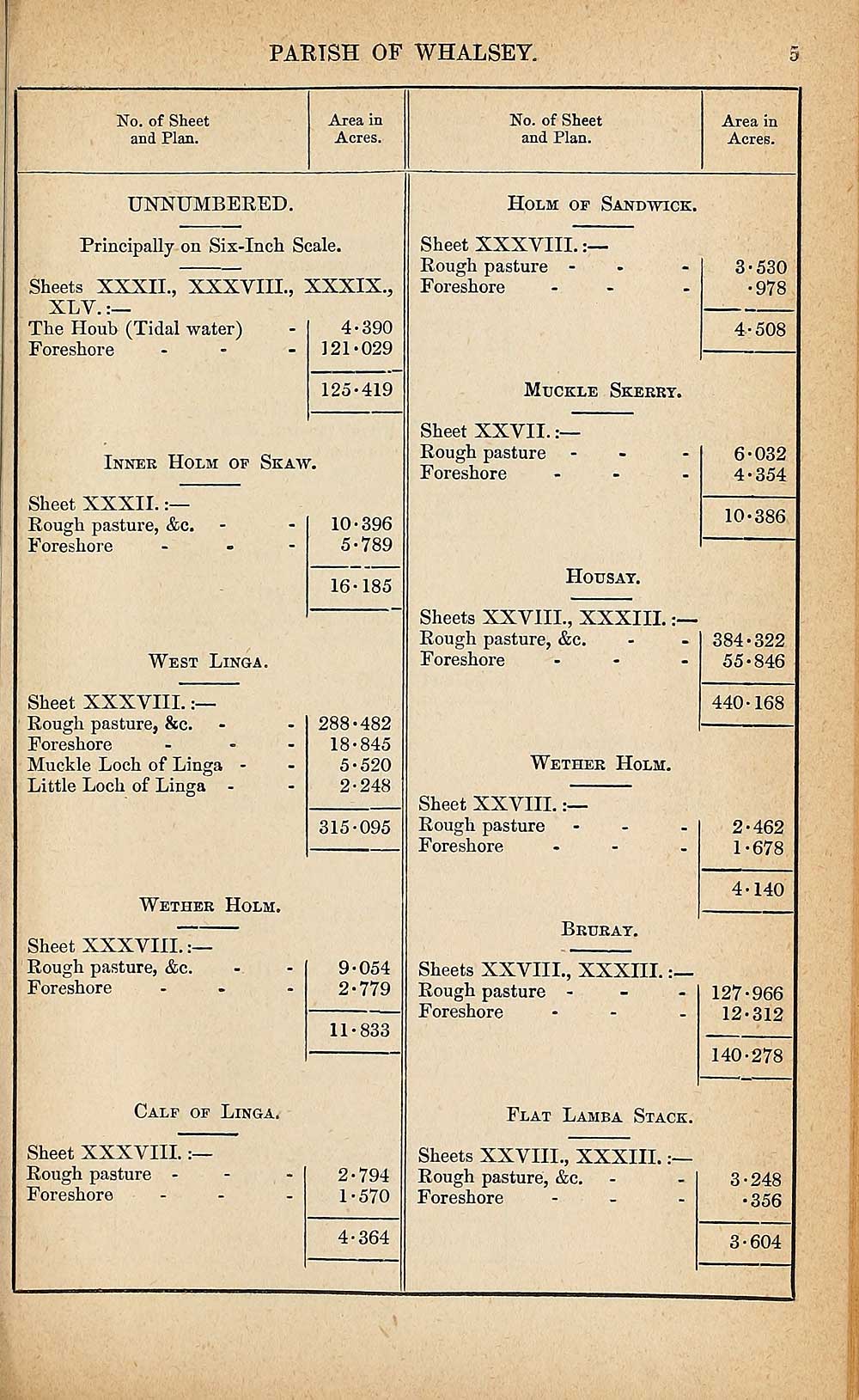
PARISH OF WHALSEY.
No. of Sheet
and Plan.
Area in
Acres.
No. of Sheet
and Plan.
Area in
Acres.
UNNUMBERED.
Principally on Six-Inch Scale.
Sheets XXXII., XXXVIIL, XXXIX.,
XLY.:—
The Houb (Tidal water) - 4*390
Foreshore - - - 121*029
125*419
Inner Holm of Skaw.
Sheet XXXII.
Rough pasture, &c.
Foreshore
10*396
5*789
16*185
West Ling a.
Sheet XXXVIII.
Rough pasture, &c.
Foreshore
Muckle Loch of Linga -
Little Loch of Linga -
288*482
18*845
5*520
2*248
315*095
Wether Holm.
Sheet XXXVIIL
Rough pasture, &c.
Foreshore
9*054
2*779
11*833
Calf of Linga.
Sheet XXXVIII.
Rough pasture -
Foreshore
2*794
1*570
4*364
Holm of Sandwich:.
Sheet XXXVIII.
Rough pasture -
Foreshore
3*530
•978
4*508
Muckle Skerry.
Sheet XXVII.
Rough pasture
Foreshore
Housay.
Sheets XXVIII., XXXIII.
Rough pasture, &c.
Foreshore
Wether Holm.
6*032
4*354
10*386
384*322
55*846
440*168
Sheet XXVIII.
Rough pasture
Foreshore
Bruray.
Sheets XXVIII., XXXIII.
Rough pasture -
Foreshore
2*462
1*678
4*140
127*966
12*312
140*278
Flat Lamb a Stack.
Sheets XXVIII., XXXIII.
Rough pasture, &c.
Foreshore
3*248
•356
3*604
No. of Sheet
and Plan.
Area in
Acres.
No. of Sheet
and Plan.
Area in
Acres.
UNNUMBERED.
Principally on Six-Inch Scale.
Sheets XXXII., XXXVIIL, XXXIX.,
XLY.:—
The Houb (Tidal water) - 4*390
Foreshore - - - 121*029
125*419
Inner Holm of Skaw.
Sheet XXXII.
Rough pasture, &c.
Foreshore
10*396
5*789
16*185
West Ling a.
Sheet XXXVIII.
Rough pasture, &c.
Foreshore
Muckle Loch of Linga -
Little Loch of Linga -
288*482
18*845
5*520
2*248
315*095
Wether Holm.
Sheet XXXVIIL
Rough pasture, &c.
Foreshore
9*054
2*779
11*833
Calf of Linga.
Sheet XXXVIII.
Rough pasture -
Foreshore
2*794
1*570
4*364
Holm of Sandwich:.
Sheet XXXVIII.
Rough pasture -
Foreshore
3*530
•978
4*508
Muckle Skerry.
Sheet XXVII.
Rough pasture
Foreshore
Housay.
Sheets XXVIII., XXXIII.
Rough pasture, &c.
Foreshore
Wether Holm.
6*032
4*354
10*386
384*322
55*846
440*168
Sheet XXVIII.
Rough pasture
Foreshore
Bruray.
Sheets XXVIII., XXXIII.
Rough pasture -
Foreshore
2*462
1*678
4*140
127*966
12*312
140*278
Flat Lamb a Stack.
Sheets XXVIII., XXXIII.
Rough pasture, &c.
Foreshore
3*248
•356
3*604
Set display mode to:
![]() Universal Viewer |
Universal Viewer | ![]() Mirador |
Large image | Transcription
Mirador |
Large image | Transcription
Images and transcriptions on this page, including medium image downloads, may be used under the Creative Commons Attribution 4.0 International Licence unless otherwise stated. ![]()
| Ordnance Survey Books of Reference 1855-1882 > Unst -- Yetholm > (343) Page 5 |
|---|
| Permanent URL | https://digital.nls.uk/99375747 |
|---|
| Attribution and copyright: |
|
|---|---|
| Description | These volumes record acreages of fields and land-use information for each parish in Scotland from 1855-1882. They were compiled with the Ordnance Survey 25 inch to the mile maps for that period, which cover all the inhabited parts of Scotland. Numbered land parcels on these maps, listed consecutively within each parish, are included in the relevant parish Book of Reference. |
|---|---|
| Shelfmark | Map.Ref.C18 |
| Additional NLS resources: | |