Tain -- South Uist
(303) Index to places
Download files
Complete book:
Individual page:
Thumbnail gallery: Grid view | List view
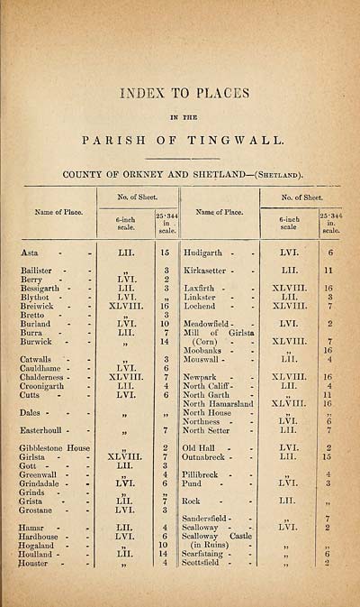
; TO PLACES
IN THE
PARISH OF TINGWALL.
COUNTY OF ORKNEY AND SHETLAND—(Shetland).
Name of Place.
No. of Sheet.
6-inch
scale.
25-344
in .
scale.
Name of Place.
No. of Sheet.
6-inch
scale
25-344
in.
scale.
Asta
Bailister
Berry
Bessigartli -
Blythot
Breiwick
Bretto
Burland
Burra
Bur wick
Cat walls
Cauldhame -
Chalderness -
Croonigarth
Cutts
Dales -
Easterhoull -
C-ibblestone House
G-irlsta
Gott -
Greenwall -
Grindadale -
Grinds
Grista
Grostane
Hamar
Hardhouse -
Hogaland
Houlland -
jSouster
LII.
LVI.
LII.
LYI.
XL VIII.
jj
LVI.
LII.
>5
LVI.
XL VIII.
LII.
LVI.
XL VIII.
LII.
LVI.
LII.
LVL
LII.
LVL
»
LII.
15
3
2
3
5>
16
3
10
7
14
3
6
7
4
6
>>
7
2
7
3
4
6
7
3
4
6
10
14
4
Hudigartk
Kirkasetter -
Laxfirth -
Linkster
Lochend
Meadowfield -
Mill of Girlsta
(Corn)
Moobanks -
Mouswall -
Newpark
North Califf -
North Garth
North Hamarsland
North House
Northness
North Setter
Old Hall -
Outnabreck -
Pillibreck
Fund
Rock
Saudersfield -
Scalloway
Scalloway Castle
(in Ruins)
Scarfataing -
Scottsfield
LVI.
LII.
XLVIII.
LII.
XLVIII.
LVI.
XLVIII.
LII.
XL VIII.
LII.
XLVIII.
V
LVL
LII.
LVI.
LII.
5)
LVI.
LII.
j*
LVI.
>}
jj
11
16
3
7
7
16
4
16
4
11
16
>5
6
2
15
4
3
Set display mode to:
![]() Universal Viewer |
Universal Viewer | ![]() Mirador |
Large image | Transcription
Mirador |
Large image | Transcription
Images and transcriptions on this page, including medium image downloads, may be used under the Creative Commons Attribution 4.0 International Licence unless otherwise stated. ![]()
| Ordnance Survey Books of Reference 1855-1882 > Tain -- South Uist > (303) Index to places |
|---|
| Permanent URL | https://digital.nls.uk/99367823 |
|---|
| Attribution and copyright: |
|
|---|---|
| Description | These volumes record acreages of fields and land-use information for each parish in Scotland from 1855-1882. They were compiled with the Ordnance Survey 25 inch to the mile maps for that period, which cover all the inhabited parts of Scotland. Numbered land parcels on these maps, listed consecutively within each parish, are included in the relevant parish Book of Reference. |
|---|---|
| Shelfmark | Map.Ref.C18 |
| Additional NLS resources: | |