Tain -- South Uist
(300) Page 8
Download files
Complete book:
Individual page:
Thumbnail gallery: Grid view | List view
8
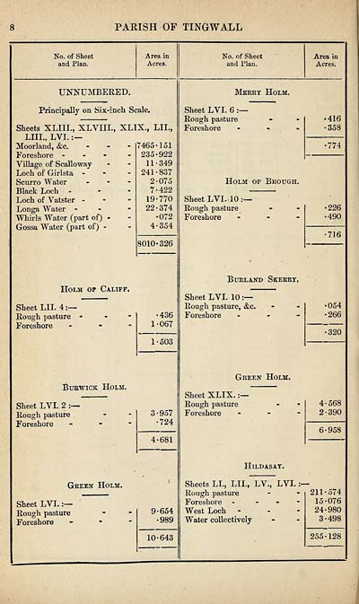
PARISH OF TINGWALL
No. of Sheet
and Plan.
Area in
Acres.
No. of Sheet
and Plan.
Area in
Acres.
UNNUMBERED.
Principally on Six-incli Scale.
Sheets XLI1L, XLYIIL,
LIII., LYI.:—
Moorland, &c.
Foreshore -
Village of Scalloway
Loch of Girlsta -
Scurro Water
Black Loch -
Loch of Yatster -
Longa Water -
Whirls Water (part of) -
Gossa Water (part of) -
XLIX., LIT.,
7465-151
235-922
11-349
241-837
2-075
7-422
19-770
22-374
•072
4-354
8010-326
Holm of Califf.
Sheet LIL 4:—
Rough pasture
Foreshore
•436
1-067
1-503
Bubwick Holm.
Sheet LVI. 2
Rough pasture
Foreshore
3-957
•724
4-681
Green Holm.
Sheet LVI.:—
Rough pasture
Foreshore
9-654
•989
10-643
Merry Holm.
Sheet LYI. 6
Rough pasture
Foreshore
416
358
■774
Holm of Brough.
Sheet LVi. 10 :—
Rough pasture
Foreshore
•226
■490
716
Burl and Skerry.
Sheet LYI. 10
Rough pasture, &c.
Foreshore
•054
•266
320
Green Holm.
Sheet XLIX.
Rough pasture
Foreshore
4-568
2-390
6-958
Hildasay.
Sheets LL, LIL, LV., LYI.
Rough pasture
Foreshore -
West Loch
Water collectively
211-574
15-076
24-980
3-498
255-128
Set display mode to:
![]() Universal Viewer |
Universal Viewer | ![]() Mirador |
Large image | Transcription
Mirador |
Large image | Transcription
Images and transcriptions on this page, including medium image downloads, may be used under the Creative Commons Attribution 4.0 International Licence unless otherwise stated. ![]()
| Ordnance Survey Books of Reference 1855-1882 > Tain -- South Uist > (300) Page 8 |
|---|
| Permanent URL | https://digital.nls.uk/99367787 |
|---|
| Attribution and copyright: |
|
|---|---|
| Description | These volumes record acreages of fields and land-use information for each parish in Scotland from 1855-1882. They were compiled with the Ordnance Survey 25 inch to the mile maps for that period, which cover all the inhabited parts of Scotland. Numbered land parcels on these maps, listed consecutively within each parish, are included in the relevant parish Book of Reference. |
|---|---|
| Shelfmark | Map.Ref.C18 |
| Additional NLS resources: | |