Tain -- South Uist
(245) Page 29
Thumbnail gallery: Grid view | List view
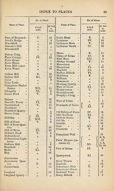
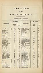
INDEX TO PLACES.
29
Name of Place.
No. of Sheet.
6 -inch
scale.
25*344
in.
scale.
Name of Place.
No. of Sheet.
6-inch
scale.
25*344
in.
scale.
Dam of Broynach -
Devil’s Bridge
Dixonfield -
Duncan’s Hill
Duncanshill
Falcon Craig
Forss Cottage
Forss House
Forss Mains
Forss Mill (corn) -
Forss Water
Callow Hill
Callow Hill
Ceise
Geise Little
Georgemas Market
Stance
Glengolly -
Green Head
Haimer
Harold’s Tower -
Hawkhillock
Heathfield -
Heathfield Quarry -
Heron Craig
Hilliclay
Hill of Forss
Hill of Forss Quar¬
ries
Hill of Howe
Holburn Head -
Holburnhead
Holburnhead Light¬
house
Holburn Hill
Hopefield -
Howe
Hoy
Janetstown
Janetstown
ries
Juniperbank
Quar-
Langland
Langland Quarry
V.
)>
>9
IV.
»»
V.
XL
XII.
XI.
V.
>>
VI.
V.
r>
J5
J>
XL
XII.
V.
)>
XI.
V.
XL
»
V.
5>
16
3
16
1
12
5»
J>
»
16
10
12
3
13
2
5
16
12
15
14
j>
2
4
1
9
13
10
3
6
2
13
6
16
14
15
13
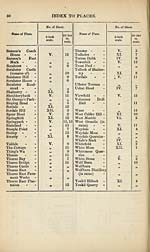
Little Head
Lythmore
Lythmore Moss
Lythmore Strath -
Mains
Mains of Brims
Marl Moss
Market Ground -
Mausoleum
Mausoleum
Mayfield
Methon Hillock -
Middleton -
Millbank
Monument -
Montyag Quarry -
Moss of Geise
Mountvernon
Mountpleasant
Murphy’s Craig -
Ness of Litter
Newlands of Geise
Old Bridge of Forss
Old Distillery
Oldfield House
Old Ho -
Ormelie
Oust
Over town
Pennyland Well -
Piets’ Houses (re¬
mains of)
Port of Brims
Quarrycrook
River Thurso
Roadside
Robertson’s Hole -
Robertson’s Point -
Rockwell Point
Rossy Hillock
V.
IV.
V.
IV.
V.
IV.
XII.
V.
VI.
XL
VI.
V.
??
>»
XL
V.
»»
XI.
IV.
XL
V.
XI.
V.
J)
XI.
IV.
XI.
>5
V.
99
>9
6
16
13
16
11
8
5
11
• ?
12
4
5
15
2
14
2,6
15
11
8
1
13
2
16
3
15
11
15
1
13
II
6, 9,
13
2, 4,
12, 16
8
16
3
16
2
19
11
8
29
Name of Place.
No. of Sheet.
6 -inch
scale.
25*344
in.
scale.
Name of Place.
No. of Sheet.
6-inch
scale.
25*344
in.
scale.
Dam of Broynach -
Devil’s Bridge
Dixonfield -
Duncan’s Hill
Duncanshill
Falcon Craig
Forss Cottage
Forss House
Forss Mains
Forss Mill (corn) -
Forss Water
Callow Hill
Callow Hill
Ceise
Geise Little
Georgemas Market
Stance
Glengolly -
Green Head
Haimer
Harold’s Tower -
Hawkhillock
Heathfield -
Heathfield Quarry -
Heron Craig
Hilliclay
Hill of Forss
Hill of Forss Quar¬
ries
Hill of Howe
Holburn Head -
Holburnhead
Holburnhead Light¬
house
Holburn Hill
Hopefield -
Howe
Hoy
Janetstown
Janetstown
ries
Juniperbank
Quar-
Langland
Langland Quarry
V.
)>
>9
IV.
»»
V.
XL
XII.
XI.
V.
>>
VI.
V.
r>
J5
J>
XL
XII.
V.
)>
XI.
V.
XL
»
V.
5>
16
3
16
1
12
5»
J>
»
16
10
12
3
13
2
5
16
12
15
14
j>
2
4
1
9
13
10
3
6
2
13
6
16
14
15
13
Little Head
Lythmore
Lythmore Moss
Lythmore Strath -
Mains
Mains of Brims
Marl Moss
Market Ground -
Mausoleum
Mausoleum
Mayfield
Methon Hillock -
Middleton -
Millbank
Monument -
Montyag Quarry -
Moss of Geise
Mountvernon
Mountpleasant
Murphy’s Craig -
Ness of Litter
Newlands of Geise
Old Bridge of Forss
Old Distillery
Oldfield House
Old Ho -
Ormelie
Oust
Over town
Pennyland Well -
Piets’ Houses (re¬
mains of)
Port of Brims
Quarrycrook
River Thurso
Roadside
Robertson’s Hole -
Robertson’s Point -
Rockwell Point
Rossy Hillock
V.
IV.
V.
IV.
V.
IV.
XII.
V.
VI.
XL
VI.
V.
??
>»
XL
V.
»»
XI.
IV.
XL
V.
XI.
V.
J)
XI.
IV.
XI.
>5
V.
99
>9
6
16
13
16
11
8
5
11
• ?
12
4
5
15
2
14
2,6
15
11
8
1
13
2
16
3
15
11
15
1
13
II
6, 9,
13
2, 4,
12, 16
8
16
3
16
2
19
11
8
Set display mode to:
![]() Universal Viewer |
Universal Viewer | ![]() Mirador |
Large image | Transcription
Mirador |
Large image | Transcription
Images and transcriptions on this page, including medium image downloads, may be used under the Creative Commons Attribution 4.0 International Licence unless otherwise stated. ![]()
| Ordnance Survey Books of Reference 1855-1882 > Tain -- South Uist > (245) Page 29 |
|---|
| Permanent URL | https://digital.nls.uk/99367199 |
|---|
| Attribution and copyright: |
|
|---|---|
| Description | These volumes record acreages of fields and land-use information for each parish in Scotland from 1855-1882. They were compiled with the Ordnance Survey 25 inch to the mile maps for that period, which cover all the inhabited parts of Scotland. Numbered land parcels on these maps, listed consecutively within each parish, are included in the relevant parish Book of Reference. |
|---|---|
| Shelfmark | Map.Ref.C18 |
| Additional NLS resources: | |