Tain -- South Uist
(187) [Page 7]

Download files
Complete book:
Individual page:
Thumbnail gallery: Grid view | List view
![(187) [Page 7] -](https://deriv.nls.uk/dcn17/9936/99366529.17.jpg)
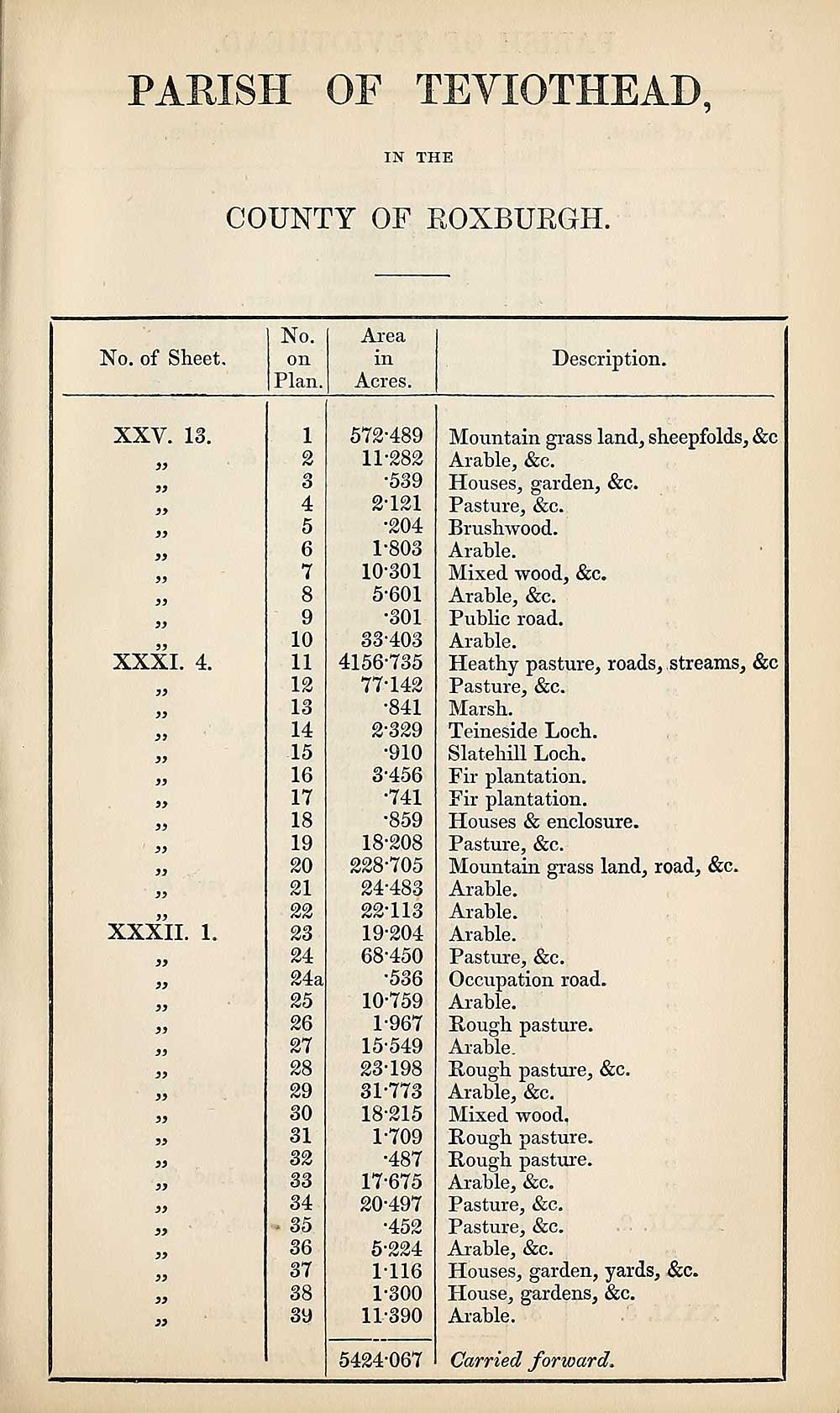
PARISH OF TEVIOTHEAD,
IN THE
COUNTY OF ROXBURGH.
No. of Sheet,
No.
on
Plan.
Area
in
Acres.
Description.
XXV. 13.
a
)>
)>
3i
33
33
33
XXXI. 4.
33
33
33
33
33
33
33
33
33
XXXII. 1.
33
33
33
33
33
33
33
33
33
33
33
33
33
33
33
1
2
3
4
5
6
7
8
9
10
11
12
13
14
15
16
17
18
19
20
21
22
23
24
24a
25
26
27
28
29
30
31
34
35
36
37
38
39
572-489
11-282
•539
2-121
•204
1- 803
10-301
5-601
*301
33-403
4156-735
77-142
•841
2- 329
•910
3- 456
•741
•859
18-208
228-705
24-483
22- 113
19- 204
68-450
•536
10- 759
1-967
15-549
23- 198
31-773
18-215
1-709
•487
17-675
20- 497
•452
5-224
1-116
1-300
11- 390
Mountain grass land, sheepfolds, &c
Arable, &c.
Houses, garden, &c.
Pasture, &c.
Brushwood.
Arable.
Mixed wood, &c.
Arable, &c.
Public road.
Arable.
Heathy pasture, roads, streams, &c
Pasture, &c.
Marsh.
Teineside Loch.
Slatehill Loch.
Fir plantation.
Fir plantation.
Houses & enclosure.
Pasture, &c.
Mountain grass land, road, &c.
Arable.
Arable.
Arable.
Pasture, &c.
Occupation road.
Arable.
Rough pasture.
Arable.
Rough pasture, &c.
Arable, &c.
Mixed wood.
Rough pasture.
Rough pasture.
Arable, &c.
Pasture, &c.
Pasture, &c.
Ar able, &c.
Houses, garden, yards, &c.
House, gardens, &c.
Arable.
5424-067 Carried forward.
Set display mode to:
![]() Universal Viewer |
Universal Viewer | ![]() Mirador |
Large image | Transcription
Mirador |
Large image | Transcription
Images and transcriptions on this page, including medium image downloads, may be used under the Creative Commons Attribution 4.0 International Licence unless otherwise stated. ![]()
| Ordnance Survey Books of Reference 1855-1882 > Tain -- South Uist > (187) [Page 7] |
|---|
| Permanent URL | https://digital.nls.uk/99366527 |
|---|
| Attribution and copyright: |
|
|---|---|
| Description | These volumes record acreages of fields and land-use information for each parish in Scotland from 1855-1882. They were compiled with the Ordnance Survey 25 inch to the mile maps for that period, which cover all the inhabited parts of Scotland. Numbered land parcels on these maps, listed consecutively within each parish, are included in the relevant parish Book of Reference. |
|---|---|
| Shelfmark | Map.Ref.C18 |
| Additional NLS resources: | |