Tain -- South Uist
(61) Page 19
Download files
Complete book:
Individual page:
Thumbnail gallery: Grid view | List view
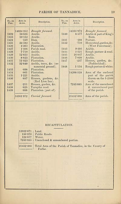
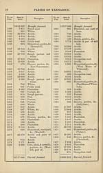
PARISH OF TANNADICE.
19
No. on
Plan.
Area in
Acres.
Description.
No. on
Plan.
Area in
Acres.
Description.
1422
1423
1424
1425
1426
1427
1428
1429
1430
1431
1432
1433
1434
1435
1436
1437
1438
1439
14024-252
10-638
10- 152
•159
34-582
4-263
1-406
7- 710
12-853
8- 823
11- 923
32-840
•098
•061
1-221
•667
•211
•025
•088
14161-972
Brought forward.
Arable.
Arable.
Dam.
Arable.
Plantation.
Parish road.
Arable.
Arable.
Plantation.
Plantation.
Arable, trees, &c. (or¬
namental ground).
Plantation.
Plantation.
Arable.
Houses, gardens, &c
(R,ed Lion Inn).
Houses, garden, &c.
Turnpike road.
Plantation (part of).
Carried forward.
1440
1441
1442
1443
1444
1445
1446
1447
1448
14161-972
8- 577
•188
•710
9- 393
1-521
16-887
7-899
•237
1-134
14208-518
7243-885
21452-403
Brought forward.
Arable & part of King’s
Burn.
Pasture.
Homestead, garden,&c.
(West Forestmuir).
Arable.
Rough pasture & road.
Arable.
Arable.
Houses, garden, &c.
(Paddockhall).
Rough pasture & whins.
Area of the enclosed
part of the parish
drawn on the 1-2500
scale.
Area of the unenclosed
& unnumbered part
of the parish.
Area of the parish.
RECAPITULATION.
13932-671
150-970
124-877
7243-885
21452-403
Land.
Public Roads.
Water.
Unenclosed & unnumbered portion.
Total Area of the Parish of Tannadice, in the County of
F orfar.
Set display mode to:
![]() Universal Viewer |
Universal Viewer | ![]() Mirador |
Large image | Transcription
Mirador |
Large image | Transcription
Images and transcriptions on this page, including medium image downloads, may be used under the Creative Commons Attribution 4.0 International Licence unless otherwise stated. ![]()
| Ordnance Survey Books of Reference 1855-1882 > Tain -- South Uist > (61) Page 19 |
|---|
| Permanent URL | https://digital.nls.uk/99365135 |
|---|
| Attribution and copyright: |
|
|---|---|
| Description | These volumes record acreages of fields and land-use information for each parish in Scotland from 1855-1882. They were compiled with the Ordnance Survey 25 inch to the mile maps for that period, which cover all the inhabited parts of Scotland. Numbered land parcels on these maps, listed consecutively within each parish, are included in the relevant parish Book of Reference. |
|---|---|
| Shelfmark | Map.Ref.C18 |
| Additional NLS resources: | |