Tain -- South Uist
(33) Page 19
Download files
Complete book:
Individual page:
Thumbnail gallery: Grid view | List view
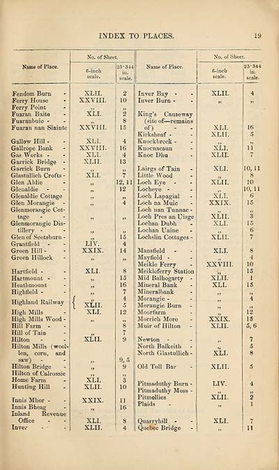
INDEX TO PLACES.
19
Name of Place.
No. of Sheet.
6-inch
scale.
25-344
in.
scale.
Name of Place.
No. of Sheet.
6-inch
scale.
125-344
in.
scale.
Fendom Burn
Ferry House
Ferry Point
Fuaran Baite
Fuaranbuie -
Fuaran nan Slainte
Gallow Hill -
Gallrope Bank
Gas Works -
Garrick Bridge -
Garrick Burn
Glastullicli Crofts -
Glen Aldie
Glenaldie
Glenaldie Cottage
Glen Morangie
Glenmorangie Cot¬
tage
Glenmorangie Dis¬
tillery -
Glen of Scotsburn -
Grantfield
Green Hill -
Green Hillock
Hartfield -
Hartmount -
Heatbmount
Highfield -
Highland Railway
High Mills
High Mills Wood -
Hill Farm -
Hill of Tain
Hilton
Hilton Mills (wool¬
len, corn, and
saw)
Hilton Bridge
Hilton of Calrossie
Home Farm
Hunting Hill
Tnnis Mhor -
Innis Bheag
Inland Revenue
Office
Inver
XLII.
XXVIII.
XLI.
XXVIII.
XLI.
XXVIII.
XLI.
XLII.
XLI.
LIV.
XXIX.
XLI.
XLII.
XLI.
XLII.
XLI.
XLII.
XXIX.
XLI.
XLII.
2
10
2
8
15
4
16
4
13
>>
7
12, 11
12
»
4
15
4
14
8
15
16
7
4
5
12
n
8
7
9
9, 5
9
3
10
11
16
8
4
Inver Bay -
Inver Burn -
King’s Causeway
(site of—remains
of) - -
Kirksheaf -
Knockbreck -
Knocnacaun
Knoc Dhu
Lairgs of Tain
Little Wood
Loch Eye
Locheye -
Loch Lapagial
Loch na Muic
Loch nan Tunnac -
Loch Pres an Uisge
Lochan Dubh
Lochan Uaine
Lochslin Cottages -
Mansfield
Mayfield -
Meikle Ferry
Meikleferry Station
Mid Balhogarty -
Mineral Bank
Miner albank
Morangie -
Morangie Burn
Moorfarm
Morrich More
Muir of Hilton
Newton
North Balkeith
North Glastullich -
Old Toll Bar
Pitmaduthy Burn
Pitmaduthy Moss
Pitmellies
Plaids
Quarryhill -
Quebec Bridge
XLII.
XLI.
XLII.
XLI.
XLII.
XLI.
XLII.
XLI.
XXIX.
XLII.
XLI.
XLII.
XLI.
XXVIII.
XLII.
XLI.
XXIX.
XLII.
XLI.
XLII.
LIV.
XLII.
XLI.
16
5
»
11
10, 11
8
10
10, 11
6
15
>>
3
15
6
7
8
4
10
15
1
15
4
jj
12
15
5, 6
7
5
8
7
11
Set display mode to:
![]() Universal Viewer |
Universal Viewer | ![]() Mirador |
Large image | Transcription
Mirador |
Large image | Transcription
Images and transcriptions on this page, including medium image downloads, may be used under the Creative Commons Attribution 4.0 International Licence unless otherwise stated. ![]()
| Ordnance Survey Books of Reference 1855-1882 > Tain -- South Uist > (33) Page 19 |
|---|
| Permanent URL | https://digital.nls.uk/99364799 |
|---|
| Attribution and copyright: |
|
|---|---|
| Description | These volumes record acreages of fields and land-use information for each parish in Scotland from 1855-1882. They were compiled with the Ordnance Survey 25 inch to the mile maps for that period, which cover all the inhabited parts of Scotland. Numbered land parcels on these maps, listed consecutively within each parish, are included in the relevant parish Book of Reference. |
|---|---|
| Shelfmark | Map.Ref.C18 |
| Additional NLS resources: | |