Slains -- Stronsay
(458) Index to places - Parish of Strathdon (Det.)
Download files
Complete book:
Individual page:
Thumbnail gallery: Grid view | List view
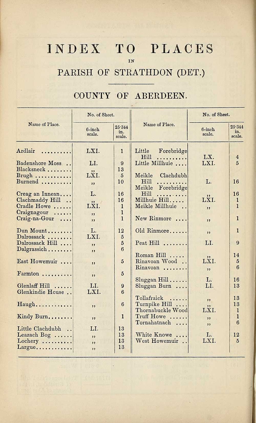
PLACES
INDEX TO
IN
PARISH OF STRATHDON (DET.)
COUNTY OF ABERDEEN.
Name of Place.
No. of Sheet.
6-inch
scale.
25-314
in.
scale.
Name of Place.
No. of Sheet.
6-inch
scale.
25-344
in.
scale.
Ardlair
Badenshore Moss
Blacksneck
Brugh
Burnend
Creag an Innean....
Clachmaddy Hill ..
Cradle Howe
Craignagour
Craig-na-Gour ...,
Dun Mount
Dalrossack
Dalrossack Hill ....
Dalgrassicli
East Howemuir . „..
Farmton
Glenlaff Hill
Glenkindie House ..
Haugh
Kindy Burn,
Little Cladidubh
Leazach Bog . ..
Lochery
Largue
LXI.
LI.
LXI.
n
L.
a
LXI.
a
a
L.
LXI.
a
a
LI.
LXI.
a
ii
LI.
a
ii
1
9
13
5
10
16
16
1
1
1
12
5
5
6
5
5
9
6
6
1
13
13
13
13
Little Forebridge
Hill
Little Millhuie ..
Meikle Clachdubh
Hill
Meikle Forebridge
Hill
Millhuie Hill
Meikle Millhuie .
New Rinmore ...
Old Rinmore,
Peat Hill
Roman Hill . . .
Rinavoan Wood
Rinavoan
Sluggan Hill.
Sluggan Burn
Tollafraick ....
Turnpike Hill . .
Thornabuckle Wood
Truff Howe ....
Tornahatnach ..
White Knowe ..
West Howemuir
LX.
LXI.
a
LXI.
LI.
a
LXI.
a
L.
LI.
a
a
LXI.
a
a
L.
LXI.
16
16
1
1
14
5
6
16
13
13
13
1
1
6
12
5
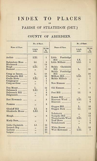
Set display mode to:
![]() Universal Viewer |
Universal Viewer | ![]() Mirador |
Large image | Transcription
Mirador |
Large image | Transcription
Images and transcriptions on this page, including medium image downloads, may be used under the Creative Commons Attribution 4.0 International Licence unless otherwise stated. ![]()
| Ordnance Survey Books of Reference 1855-1882 > Slains -- Stronsay > (458) Index to places - Parish of Strathdon (Det.) |
|---|
| Permanent URL | https://digital.nls.uk/99363511 |
|---|
| Attribution and copyright: |
|
|---|---|
| Description | These volumes record acreages of fields and land-use information for each parish in Scotland from 1855-1882. They were compiled with the Ordnance Survey 25 inch to the mile maps for that period, which cover all the inhabited parts of Scotland. Numbered land parcels on these maps, listed consecutively within each parish, are included in the relevant parish Book of Reference. |
|---|---|
| Shelfmark | Map.Ref.C18 |
| Additional NLS resources: | |