Slains -- Stronsay
(176) Page 28
(177) next ›››
Agents for the sale of the Ordnance plans
Download files
Complete book:
Individual page:
Thumbnail gallery: Grid view | List view
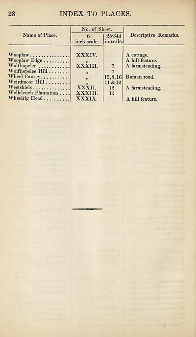
28
INDEX TO PLACES.
Name of Place.
No. of Sheet.
6
inch scale.
25*344
in. scale.
Descriptive Remarks.
Wooplaw
Wooplaw Edge
Wolfhopelee
Wolfhopelee Hill . ...
Wheel Causey
Weirdmoor Hill
Westshiels
Wellcleuch Plantation
Wheelrig Head
XXXIV.
XXXIII.
XXXII.
XXXIII.
XXXIX.
7
7
12,8,16
11 & 12
12
12
A cottage.
A hill feature.
A farmsteading.
Roman road.
A farmsteading.
A hill feature.
Set display mode to:
![]() Universal Viewer |
Universal Viewer | ![]() Mirador |
Large image | Transcription
Mirador |
Large image | Transcription
Images and transcriptions on this page, including medium image downloads, may be used under the Creative Commons Attribution 4.0 International Licence unless otherwise stated. ![]()
| Ordnance Survey Books of Reference 1855-1882 > Slains -- Stronsay > (176) Page 28 |
|---|
| Permanent URL | https://digital.nls.uk/99360439 |
|---|
| Attribution and copyright: |
|
|---|---|
| Description | These volumes record acreages of fields and land-use information for each parish in Scotland from 1855-1882. They were compiled with the Ordnance Survey 25 inch to the mile maps for that period, which cover all the inhabited parts of Scotland. Numbered land parcels on these maps, listed consecutively within each parish, are included in the relevant parish Book of Reference. |
|---|---|
| Shelfmark | Map.Ref.C18 |
| Additional NLS resources: | |