Saddell and Skipness -- Skene
(506) Page 34
(507) next ›››
Agents for the sale of the Ordnance plans
Download files
Complete book:
Individual page:
Thumbnail gallery: Grid view | List view
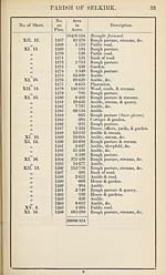
34
PAEISH OF SELKIRK (DETACHED).
No. of Sheet.
No.
on
Plan.
Area
in
Acres.
Description.
XV
1
S
4
5
6
7
8
9
10
11
12
13
14
15
168037
10-098
14-778
8-531
4-906
6-448
4-993
1-818
1-719
3-694
12-193
•251
70-053
1122-067
1-047
1430-633
Moor, streams, roads, &c.
Arable & stream.
Arable.
Arable.
Wood.
Arable.
Arable.
House, offices, garden, & yards.
Plantation.
Rough pasture.
Rough pasture, stream, & roads.
House & garden.
Rough pasture.
Moor, streams, old quarries, &c.
S beepfold.
Area of Selkirk Parish (detached).
NoTE.—There are neither roads, railways, nor water in Selkirk Ph. (Detached).
RECAPITULATION.
19638-218
307-019
108-811
26-438
6-038
20086-524
1430-633
Land.
Water.
Public Roads.
Private Roads.
Railway.
Area of Selkirk Parish (exclusive
of detached portion).
Area of Selkirk Parish (detached).
Total Area of Selkirk Parish, in the
County of Selkirk.
N.B.—The County Boundary runs through the Parish of Selkirk.
21517-157 Acres is the Area of the portion in Selkirkshire, the other
portions are in Roxburghshire.
21517-157
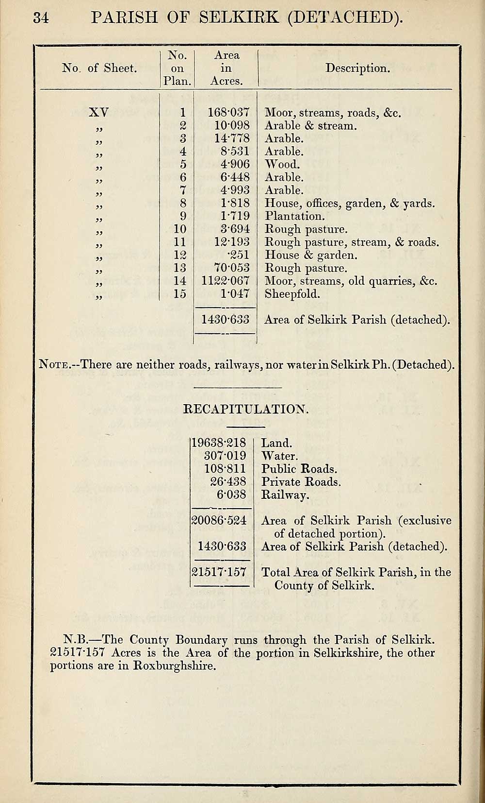
Set display mode to:
![]() Universal Viewer |
Universal Viewer | ![]() Mirador |
Large image | Transcription
Mirador |
Large image | Transcription
Images and transcriptions on this page, including medium image downloads, may be used under the Creative Commons Attribution 4.0 International Licence unless otherwise stated. ![]()
| Ordnance Survey Books of Reference 1855-1882 > Saddell and Skipness -- Skene > (506) Page 34 |
|---|
| Permanent URL | https://digital.nls.uk/99356715 |
|---|
| Attribution and copyright: |
|
|---|---|
| Description | These volumes record acreages of fields and land-use information for each parish in Scotland from 1855-1882. They were compiled with the Ordnance Survey 25 inch to the mile maps for that period, which cover all the inhabited parts of Scotland. Numbered land parcels on these maps, listed consecutively within each parish, are included in the relevant parish Book of Reference. |
|---|---|
| Shelfmark | Map.Ref.C18 |
| Additional NLS resources: | |