Rathven -- Ruthven
(634) Page 10
Download files
Complete book:
Individual page:
Thumbnail gallery: Grid view | List view
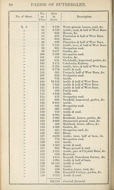
10
PARISH OF RUTHERGLEN
No. of Sheet.
No.
on
Plan.
Area
in
Acres.
Description.
X. 3.
sr
}}
91
92
93
94
95
96
97
98
99
100
101
102
103
104
105
108
107
108
109
110
111
112
113
114
115
116
117
118
119
120
121
122
123
124
125
126
127
128
129
130
131
132
133
134
135
136
137
138
139
140
1*256
4*729
*056
*278
*013
•069
7*238
•084
1077
1'206
•416
'631
1175
1- 284
6*770
•508
•020
•756
10-132
7-543
4-495
•264
4-840
•139
•699
2- 012
•241
•260
•579
2- 805
1- 069
2- 068
•468
1- 500
•315
•012
3- 670
•778
•415
P562
•022
2- 425
•350
1-835
4- 094
18-425
•802
•459
•926
3- 573
106-343
Waste ground, houses, road, &c.
Arable, road, & half of West Burn,
Houses, &c.
Plantation & half of West Bum.
House.
Plantation & half of West Burn.
Arable, trees, & half of West Burn.
Occupation road.
Garden, &c.
Occupation road.
Garden, &c.
Blaekfaulds, homestead, garden, &c.
Caledonian Kailway.
Arable, trees, & half of West Burn.
Arable & road.
Footpath, half of West Burn, &c.
Occupation road.
Arable.
Arable & half of West Bum.
Arable & half of West Burn.
Arable & half of West Bum.
Parish road.
Arable.
Occupation road.
Newfield, homestead, garden, &e.
Arable.
Occupation road.
Arable.
Arable & road.
Arable.
Bearlands, houses, garden, &c.
Ornamental ground, road, &c.
Muirbank, house, offices, &e.
Garden, &c.
Occupation road, &c.
House.
Arable, trees, half of bum, &c.
Occupation road.
Arable.
Arable & road.
Waste ground & road. ,
Arable, part of Cityford Burn, &c.
Keservoir.
Burnside Powerloom Factory, &c.
Arable & half of bum.
Arable & road.
Arable.
Garden, house, road, &c.
Greenhill Cottage, garden, &c.
Arable & road.
Carried forward.
Set display mode to:
![]() Universal Viewer |
Universal Viewer | ![]() Mirador |
Large image | Transcription
Mirador |
Large image | Transcription
Images and transcriptions on this page, including medium image downloads, may be used under the Creative Commons Attribution 4.0 International Licence unless otherwise stated. ![]()
| Ordnance Survey Books of Reference 1855-1882 > Rathven -- Ruthven > (634) Page 10 |
|---|
| Permanent URL | https://digital.nls.uk/99350591 |
|---|
| Attribution and copyright: |
|
|---|---|
| Description | These volumes record acreages of fields and land-use information for each parish in Scotland from 1855-1882. They were compiled with the Ordnance Survey 25 inch to the mile maps for that period, which cover all the inhabited parts of Scotland. Numbered land parcels on these maps, listed consecutively within each parish, are included in the relevant parish Book of Reference. |
|---|---|
| Shelfmark | Map.Ref.C18 |
| Additional NLS resources: | |