Rathven -- Ruthven
(422) Page 12
Download files
Complete book:
Individual page:
Thumbnail gallery: Grid view | List view
12
PARISH OF ROSSKEEN.
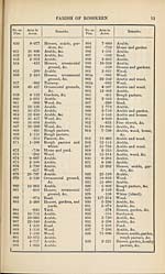
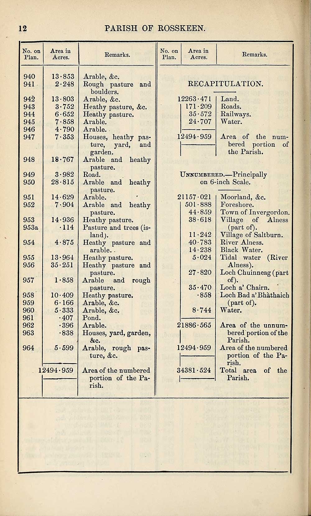
No. on
Plan.
940
941
942
943
944
945
946
947
948
949
950
951
952
953
953a
954
955
956
957
958
959
960
961
962
963
964
Area in
Acres.
13-853
2-248
13-803
3-752
652
■858
790
353
18-767
3- 982
28-815
14-629
7-904
14-936
•114
4- 875
13-964
35-251
1-858
10-409
6-166
5- 333
•407
•396
•838
5-599
12494-959
Remarks.
and
heathy
heathy
heathy
Arable, &c.
Rough pasture
boulders.
Arable, &c.
Heathy pasture, &c.
Heathy pasture.
Arable.
Arable.
Houses, heathy pas¬
ture, yard, and
garden.
Arable and
pasture.
Road.
Arable and
pasture.
Arable.
Arable and
pasture.
Heathy pasture.
Pasture and trees (is¬
land).
Heathy pasture and
arable..
Heathy pasture.
Heathy pasture and
pasture.
Arable and
pasture.
Heathy pasture.
Arable, &c.
Arable, &c.
Pond.
Arable.
Houses, yard, garden,
&c.
Arable, rough pas¬
ture, &c.
Area of the numbered
portion of the Pa¬
rish.
rough
No. on
Plan.
Area in
Acres.
Remarks.
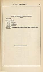
RECAPITULATION.
12263-471
171-209
35-572
24-707
Land.
Roads.
Railways.
Water.
Area of the num¬
bered portion of
the Parish.
Unnumbered.—Principally
on 6-inch Scale.
12494-959
21157-021
501-888
44-859
38-618
11-242
40-783
14-238
5-024
27•820
35-470
•858
8-744
21886-565
12494-959
34381-524
Moorland, &c.
Foreshore.
Town of Invergorden.
Village of Alness
(part of).
Village of Saltburn.
River Alness.
Black Water.
Tidal water (River
Alness).
Loch Chuinneag(part
of).
Loch a’ Chairn.
Loch Bad a’Bhathaich
(part of).
Water.
Area of the unnum¬
bered portion of the
Parish.
Area of the numbered
portion of the Pa¬
rish.
Total area of the
Parish.
PARISH OF ROSSKEEN.
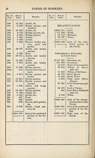
No. on
Plan.
940
941
942
943
944
945
946
947
948
949
950
951
952
953
953a
954
955
956
957
958
959
960
961
962
963
964
Area in
Acres.
13-853
2-248
13-803
3-752
652
■858
790
353
18-767
3- 982
28-815
14-629
7-904
14-936
•114
4- 875
13-964
35-251
1-858
10-409
6-166
5- 333
•407
•396
•838
5-599
12494-959
Remarks.
and
heathy
heathy
heathy
Arable, &c.
Rough pasture
boulders.
Arable, &c.
Heathy pasture, &c.
Heathy pasture.
Arable.
Arable.
Houses, heathy pas¬
ture, yard, and
garden.
Arable and
pasture.
Road.
Arable and
pasture.
Arable.
Arable and
pasture.
Heathy pasture.
Pasture and trees (is¬
land).
Heathy pasture and
arable..
Heathy pasture.
Heathy pasture and
pasture.
Arable and
pasture.
Heathy pasture.
Arable, &c.
Arable, &c.
Pond.
Arable.
Houses, yard, garden,
&c.
Arable, rough pas¬
ture, &c.
Area of the numbered
portion of the Pa¬
rish.
rough
No. on
Plan.
Area in
Acres.
Remarks.
RECAPITULATION.
12263-471
171-209
35-572
24-707
Land.
Roads.
Railways.
Water.
Area of the num¬
bered portion of
the Parish.
Unnumbered.—Principally
on 6-inch Scale.
12494-959
21157-021
501-888
44-859
38-618
11-242
40-783
14-238
5-024
27•820
35-470
•858
8-744
21886-565
12494-959
34381-524
Moorland, &c.
Foreshore.
Town of Invergorden.
Village of Alness
(part of).
Village of Saltburn.
River Alness.
Black Water.
Tidal water (River
Alness).
Loch Chuinneag(part
of).
Loch a’ Chairn.
Loch Bad a’Bhathaich
(part of).
Water.
Area of the unnum¬
bered portion of the
Parish.
Area of the numbered
portion of the Pa¬
rish.
Total area of the
Parish.
Set display mode to:
![]() Universal Viewer |
Universal Viewer | ![]() Mirador |
Large image | Transcription
Mirador |
Large image | Transcription
Images and transcriptions on this page, including medium image downloads, may be used under the Creative Commons Attribution 4.0 International Licence unless otherwise stated. ![]()
| Ordnance Survey Books of Reference 1855-1882 > Rathven -- Ruthven > (422) Page 12 |
|---|
| Permanent URL | https://digital.nls.uk/99348239 |
|---|
| Attribution and copyright: |
|
|---|---|
| Description | These volumes record acreages of fields and land-use information for each parish in Scotland from 1855-1882. They were compiled with the Ordnance Survey 25 inch to the mile maps for that period, which cover all the inhabited parts of Scotland. Numbered land parcels on these maps, listed consecutively within each parish, are included in the relevant parish Book of Reference. |
|---|---|
| Shelfmark | Map.Ref.C18 |
| Additional NLS resources: | |