Rathven -- Ruthven
(393) Page 23

Download files
Complete book:
Individual page:
Thumbnail gallery: Grid view | List view
PARISH OF ROSNEATH
23
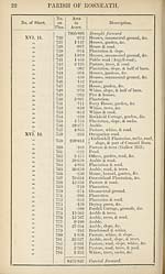
No. of Sheet.
No.
on
Plan.
Area
in
Acres.
Description.
XVI. 12.
XVII. 9.
785
786
787
788
789
8475-842
•537
20-181
2-238
329-979
•453
8829-230
Brought forward.
Pasture <&; trees.
Arable, road, & slope.
Pasture, whins, slope, & road.
Foreshore.
Pasture (Green Island).
RECAPITULATION.
8407-781
53-856
329-979
37-614
8829-230
Land.
Public roads.
Foreshore.
Water.
Total area of the Parish of Rosneath,
in the County of Dumbarton.
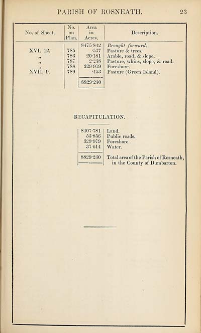
23
No. of Sheet.
No.
on
Plan.
Area
in
Acres.
Description.
XVI. 12.
XVII. 9.
785
786
787
788
789
8475-842
•537
20-181
2-238
329-979
•453
8829-230
Brought forward.
Pasture <&; trees.
Arable, road, & slope.
Pasture, whins, slope, & road.
Foreshore.
Pasture (Green Island).
RECAPITULATION.
8407-781
53-856
329-979
37-614
8829-230
Land.
Public roads.
Foreshore.
Water.
Total area of the Parish of Rosneath,
in the County of Dumbarton.
Set display mode to:
![]() Universal Viewer |
Universal Viewer | ![]() Mirador |
Large image | Transcription
Mirador |
Large image | Transcription
Images and transcriptions on this page, including medium image downloads, may be used under the Creative Commons Attribution 4.0 International Licence unless otherwise stated. ![]()
| Ordnance Survey Books of Reference 1855-1882 > Rathven -- Ruthven > (393) Page 23 |
|---|
| Permanent URL | https://digital.nls.uk/99347915 |
|---|
| Attribution and copyright: |
|
|---|---|
| Description | These volumes record acreages of fields and land-use information for each parish in Scotland from 1855-1882. They were compiled with the Ordnance Survey 25 inch to the mile maps for that period, which cover all the inhabited parts of Scotland. Numbered land parcels on these maps, listed consecutively within each parish, are included in the relevant parish Book of Reference. |
|---|---|
| Shelfmark | Map.Ref.C18 |
| Additional NLS resources: | |