Rathven -- Ruthven
(308) Page 12
Thumbnail gallery: Grid view | List view
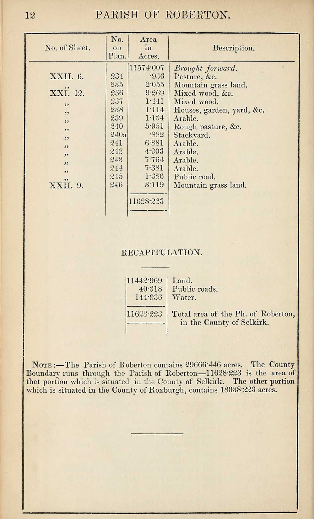
12
PAPJSH OF ROBERTON.
Ko. of Sheet.
No.
on
Plan.
Area
in
Acres.
Description.
XXII. 6.
XXL 12.
XXII. 9.
234
235
236
237
238
239
240
240a
241
242
243
244
245
246
11574-007
•936
2- 055
9-269
1-441
1114
1-134
5- 951
•882
6- 881
4-903
7*764
7-381
1-386
3- 119
11628*223
Brought forward.
Pasture, &c.
Mountain grass land.
Mixed wood, &c.
Mixed wood.
Houses, garden, yard, &c.
Arable.
Rough pasture, &c.
Stackyard.
Arable.
Arable.
Arable.
Arable.
Public road.
Mountain grass land.
RECAPITULATION.
11442-969
40-318
144-936
11628-223
Land.
Public roads.
Water.
Total area of the Ph. of Roberton,
in the County of Selkirk.
Note :—The Parish of Roberton contains 29666*446 acres. The County
Boundary runs through the Parish of Roberton—11628-223 is the area of
that portion which is situated in the County of Selkirk. The other portion
which is situated in the County of Roxburgh, contains 18038"228 acres.
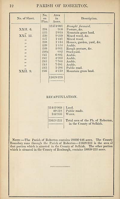
Set display mode to:
![]() Universal Viewer |
Universal Viewer | ![]() Mirador |
Large image | Transcription
Mirador |
Large image | Transcription
Images and transcriptions on this page, including medium image downloads, may be used under the Creative Commons Attribution 4.0 International Licence unless otherwise stated. ![]()
| Ordnance Survey Books of Reference 1855-1882 > Rathven -- Ruthven > (308) Page 12 |
|---|
| Permanent URL | https://digital.nls.uk/99346991 |
|---|
| Attribution and copyright: |
|
|---|---|
| Description | These volumes record acreages of fields and land-use information for each parish in Scotland from 1855-1882. They were compiled with the Ordnance Survey 25 inch to the mile maps for that period, which cover all the inhabited parts of Scotland. Numbered land parcels on these maps, listed consecutively within each parish, are included in the relevant parish Book of Reference. |
|---|---|
| Shelfmark | Map.Ref.C18 |
| Additional NLS resources: | |