Rathven -- Ruthven
(61) Page 11
Download files
Complete book:
Individual page:
Thumbnail gallery: Grid view | List view
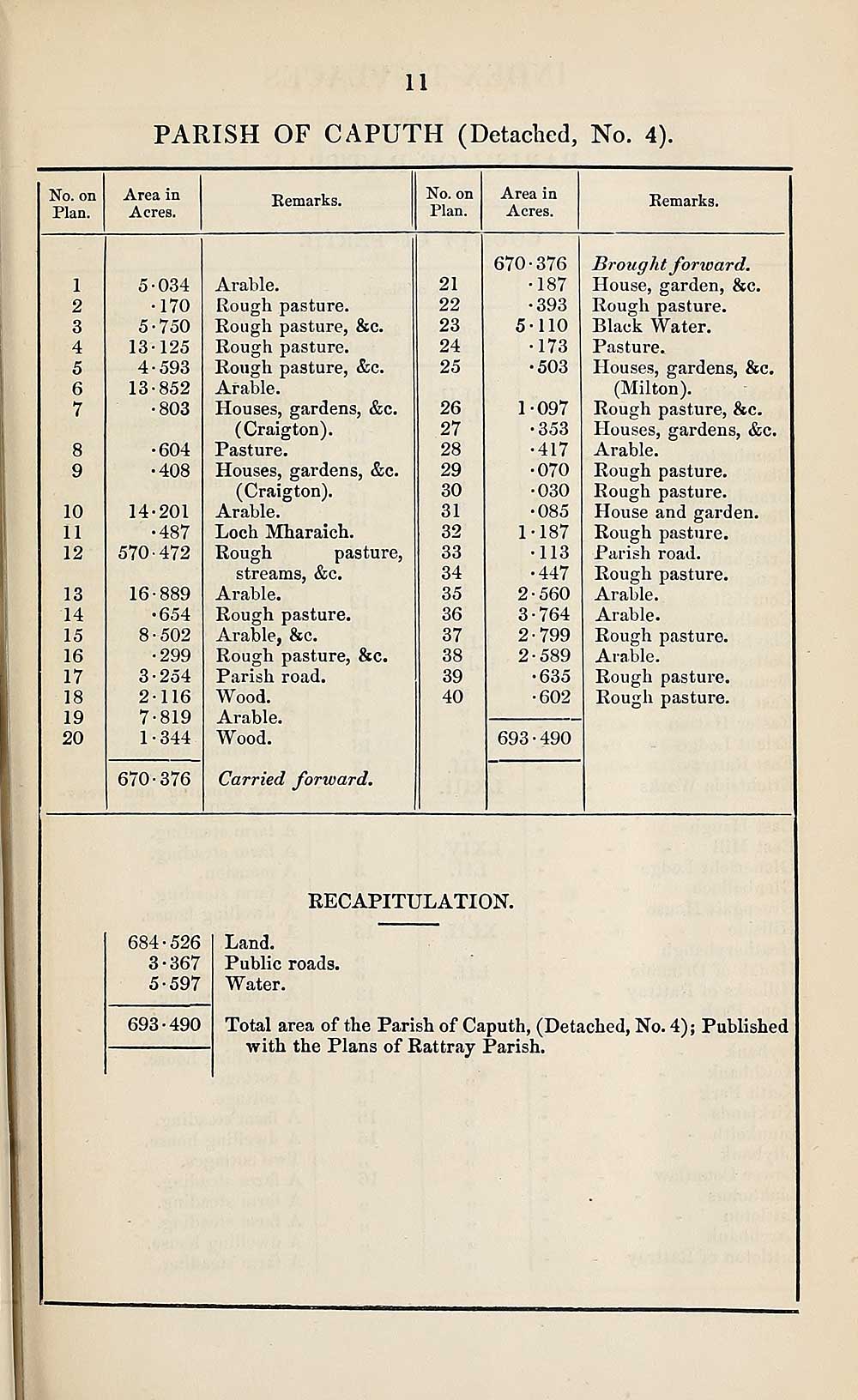
11
PARISH OF CAPUTH (Detached, No. 4).
No. on
Plan.
Area in
Acres.
Remarks.
No. on
Plan.
Area in
Acres.
Remarks.
1
2
3
4
5
6
7
8
9
10
11
12
13
14
15
16
17
18
19
20
5*034
•170
5*750
13*125
4*593
13*852
•803
•604
•408
14-201
•487
570-472
16*889
•654
8*502
•299
254
116
•819
344
670*376
Arable.
Rough pasture.
Rough pasture, &c.
Rough pasture.
Rough pasture, &c.
Arable.
Houses, gardens, &c.
(Craigton).
Pasture.
Houses, gardens, &c.
(Craigton).
Arable.
Loch Mharaich.
Rough pasture,
streams, &c.
Arable.
Rough pasture.
Arable, &c.
Rough pasture, &c.
Parish road.
Wood.
Arable.
Wood.
Carried forward.
21
22
23
24
25
26
27
28
29
30
31
32
33
34
35
36
37
38
39
40
670*376
•187
•393
5*110
•173
•503
1
097
353
417
070
030
085
•187
113
•447
•560
•764
■799
■589
•635
■602
693*490
Brought forward.
House, garden, &c.
Rough pasture.
Black Water.
Pasture.
Houses, gardens, &c.
(Milton).
Rough pasture, &c.
Houses, gardens, &c.
Arable.
Rough pasture.
Rough pasture.
House and garden.
Rough pasture.
Parish road.
Rough pasture.
Arable.
Arable.
Rough pasture.
Arable.
Rough pasture.
Rough pasture.
RECAPITULATION.
684-526
3-367
5*597
693*490
Land.
Public roads.
Water.
Total area of the Parish of Caputh, (Detached, No. 4); Published
with the Plans of Rattray Parish.
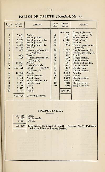
Set display mode to:
![]() Universal Viewer |
Universal Viewer | ![]() Mirador |
Large image | Transcription
Mirador |
Large image | Transcription
Images and transcriptions on this page, including medium image downloads, may be used under the Creative Commons Attribution 4.0 International Licence unless otherwise stated. ![]()
| Ordnance Survey Books of Reference 1855-1882 > Rathven -- Ruthven > (61) Page 11 |
|---|
| Permanent URL | https://digital.nls.uk/99344291 |
|---|
| Attribution and copyright: |
|
|---|---|
| Description | These volumes record acreages of fields and land-use information for each parish in Scotland from 1855-1882. They were compiled with the Ordnance Survey 25 inch to the mile maps for that period, which cover all the inhabited parts of Scotland. Numbered land parcels on these maps, listed consecutively within each parish, are included in the relevant parish Book of Reference. |
|---|---|
| Shelfmark | Map.Ref.C18 |
| Additional NLS resources: | |